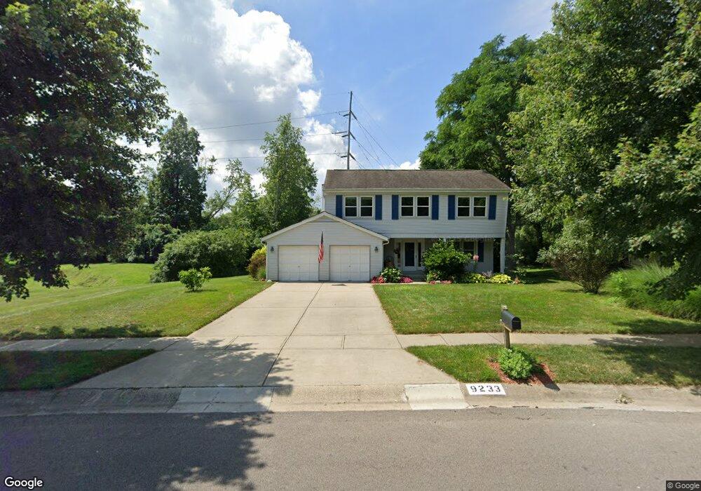
9233 Meadow Dr Maineville, OH 45039
Landen NeighborhoodEstimated Value: $406,785 - $431,000
4
Beds
3
Baths
2,088
Sq Ft
$201/Sq Ft
Est. Value
About This Home
This home is located at 9233 Meadow Dr, Maineville, OH 45039 and is currently estimated at $420,196, approximately $201 per square foot. 9233 Meadow Dr is a home located in Warren County with nearby schools including Kings Junior High School, Kings High School, and St. Margaret of York School.
Ownership History
Date
Name
Owned For
Owner Type
Purchase Details
Closed on
Aug 4, 1993
Sold by
Laing Laing and Laing Oscar Paul
Bought by
Wallace Wallace and Wallace J. Lee
Current Estimated Value
Purchase Details
Closed on
Nov 19, 1991
Sold by
Sullivan Sullivan and Sullivan Stephen J
Bought by
Laing Laing and Laing Oscar Paul
Purchase Details
Closed on
Dec 31, 1987
Sold by
Archizign Homes & Inc
Bought by
Sullivan Sullivan and Sullivan Stephen J
Purchase Details
Closed on
May 20, 1987
Sold by
Landen Farm Company
Bought by
Archizign Homes & Inc
Purchase Details
Closed on
Apr 2, 1986
Sold by
Landen Farm Company
Bought by
Landen Farm Company
Create a Home Valuation Report for This Property
The Home Valuation Report is an in-depth analysis detailing your home's value as well as a comparison with similar homes in the area
Home Values in the Area
Average Home Value in this Area
Purchase History
| Date | Buyer | Sale Price | Title Company |
|---|---|---|---|
| Wallace Wallace | $124,500 | -- | |
| Laing Laing | $114,000 | -- | |
| Sullivan Sullivan | $113,900 | -- | |
| Archizign Homes & Inc | $12,700 | -- | |
| Landen Farm Company | -- | -- |
Source: Public Records
Tax History
| Year | Tax Paid | Tax Assessment Tax Assessment Total Assessment is a certain percentage of the fair market value that is determined by local assessors to be the total taxable value of land and additions on the property. | Land | Improvement |
|---|---|---|---|---|
| 2024 | $5,917 | $113,570 | $26,250 | $87,320 |
| 2023 | $5,235 | $90,258 | $12,915 | $77,343 |
| 2022 | $5,141 | $90,258 | $12,915 | $77,343 |
| 2021 | $4,306 | $90,258 | $12,915 | $77,343 |
| 2020 | $4,162 | $73,381 | $10,500 | $62,881 |
| 2019 | $4,213 | $73,381 | $10,500 | $62,881 |
| 2018 | $4,194 | $73,381 | $10,500 | $62,881 |
| 2017 | $4,046 | $62,689 | $10,371 | $52,318 |
| 2016 | $4,149 | $62,689 | $10,371 | $52,318 |
| 2015 | $3,528 | $62,689 | $10,371 | $52,318 |
| 2014 | $3,528 | $55,480 | $9,180 | $46,300 |
| 2013 | $3,533 | $63,470 | $10,500 | $52,970 |
Source: Public Records
Map
Nearby Homes
- 3761 Green Haven Way
- 3833 Spring Mill Way
- 9498 Carriage Run Cir
- 9204 Yarmouth Dr Unit 9204
- 8839 Pollard Place
- 9547 Carriage Run Cir
- 3920 Wagon Trail Rd
- 3431 Twenty Mile Way Unit 3431
- 8819 Pembrooke St
- 3492 Twenty Mile Way Unit 3492
- 3154 Vineyard Ct
- 2956 Kingsley Ct
- 2898 Mossy Brink Ct Unit 19
- 8846 Morley Place
- 3169 Shadow Ridge Dr
- 2845 Columbia Trail
- 1942 Walnut Dr
- 8730 Exeter Place
- 8480 Island Pines Place
- 12091 Carrington Ln
- 9221 Meadow Dr
- 9203 Meadow Dr
- 9263 Meadow Dr
- 9240 Meadow Dr
- 9224 Meadow Dr
- 9187 Meadow Dr
- 3772 Townsley Dr
- 3752 Townsley Dr
- 9281 Meadow Dr
- 8941 Ripple Way
- 3825 Townsley Dr
- 3742 Townsley Dr
- 9171 Meadow Dr
- 3808 Townsley Dr
- 3848 Green Haven Way
- 8912 Ripple Way
- 8929 Ripple Way
- 3738 Townsley Dr
- 9293 Meadow Dr
- 8946 Farmdale Way