

PENDING
$10K PRICE DROP
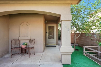
924 Telstar Loop NW Albuquerque, NM 87121
Los Volcanes NeighborhoodEstimated payment $2,124/month
Total Views
267,266
4
Beds
2.5
Baths
2,422
Sq Ft
$151
Price per Sq Ft
Highlights
- Sitting Area In Primary Bedroom
- Wooded Lot
- Private Yard
- Tony Hillerman Middle School Rated A-
- Loft
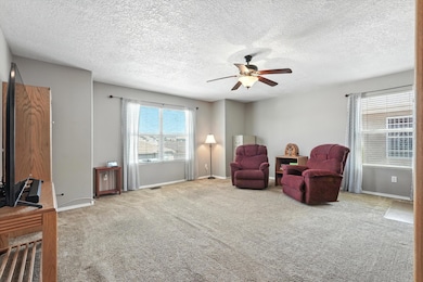
- Multiple Living Areas
About This Home
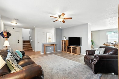
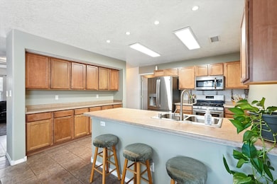
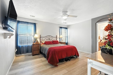
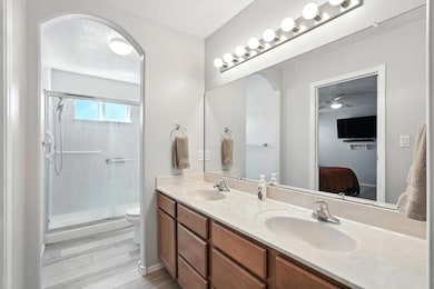
This 2 story home located in Ladera Heights has NO HOA & boasts a thoughtfully designed layout! The spacious main living room flows into the kitchen seamlessly featuring eat-in island, abundant cabinets, & an adjacent dining area, ideal for hosting. Primary suite located on main level provides convenience & privacy with its own en-suite w/ double vanity, walk in shower & walk in closet! Upstairs offers flexibility with 3 additional bedrooms and a large 2nd living space for work, play, or relaxation! The mix of tile, carpet, and vinyl wood-look flooring add style throughout. Step outside to a landscaped, walled backyard w/ turf, covered patio, & plenty of storage with 2 sheds that convey. Come enjoy nearby access to schools and parks!
Home Details
Home Type
- Single Family
Est. Annual Taxes
- $2,398
Year Built
- Built in 2007
Lot Details
- 4,792 Sq Ft Lot
- North Facing Home
- Xeriscape Landscape
- Wooded Lot
- Private Yard
- Garden
- Zoning described as R-ML*
Parking
- 2 Car Attached Garage
Home Design
- Frame Construction
- Pitched Roof
- Shingle Roof
- Stucco
Interior Spaces
- 2,422 Sq Ft Home
- Property has 1 Level
- Ceiling Fan
- Double Pane Windows
- Insulated Windows
- Sliding Windows
- Entrance Foyer
- Multiple Living Areas
- Sitting Room
- Loft
Kitchen
- Free-Standing Gas Range
- Microwave
- Dishwasher
- Disposal
Flooring
- Carpet
- Tile
- Vinyl
Bedrooms and Bathrooms
- 4 Bedrooms
- Sitting Area In Primary Bedroom
- Walk-In Closet
- Dual Sinks
- Shower Only
- Separate Shower
Laundry
- Dryer
- Washer
Outdoor Features
- Covered Patio or Porch
- Shed
Schools
- S R Marmon Elementary School
- West Mesa High School
Horse Facilities and Amenities
- Grass Field
Utilities
- Refrigerated Cooling System
- Forced Air Heating System
- Natural Gas Connected
Community Details
- Planned Unit Development
Listing and Financial Details
- Assessor Parcel Number 101005843338011108
Map
Create a Home Valuation Report for This Property
The Home Valuation Report is an in-depth analysis detailing your home's value as well as a comparison with similar homes in the area
Home Values in the Area
Average Home Value in this Area
Tax History
| Year | Tax Paid | Tax Assessment Tax Assessment Total Assessment is a certain percentage of the fair market value that is determined by local assessors to be the total taxable value of land and additions on the property. | Land | Improvement |
|---|---|---|---|---|
| 2025 | $2,398 | $64,718 | $12,750 | $51,968 |
| 2024 | $2,398 | $62,834 | $12,379 | $50,455 |
| 2023 | $2,350 | $61,003 | $12,018 | $48,985 |
| 2022 | $2,264 | $59,227 | $11,668 | $47,559 |
| 2021 | $2,181 | $57,503 | $11,329 | $46,174 |
| 2020 | $2,137 | $55,828 | $10,999 | $44,829 |
| 2019 | $2,137 | $55,828 | $10,999 | $44,829 |
| 2018 | $2,115 | $55,828 | $10,999 | $44,829 |
| 2017 | $2,043 | $55,649 | $11,329 | $44,320 |
| 2016 | $1,993 | $52,834 | $11,329 | $41,505 |
| 2015 | $51,295 | $51,295 | $10,999 | $40,296 |
| 2014 | $1,943 | $51,762 | $10,999 | $40,763 |
| 2013 | -- | $51,762 | $10,999 | $40,763 |
Source: Public Records
Property History
| Date | Event | Price | List to Sale | Price per Sq Ft |
|---|---|---|---|---|
| 11/04/2025 11/04/25 | Pending | -- | -- | -- |
| 11/02/2025 11/02/25 | Price Changed | $364,900 | -3.9% | $151 / Sq Ft |
| 10/04/2025 10/04/25 | Off Market | -- | -- | -- |
| 09/30/2025 09/30/25 | For Sale | $379,900 | 0.0% | $157 / Sq Ft |
| 09/24/2025 09/24/25 | Price Changed | $379,900 | +1.3% | $157 / Sq Ft |
| 09/03/2025 09/03/25 | For Sale | $375,000 | -- | $155 / Sq Ft |
Source: Southwest MLS (Greater Albuquerque Association of REALTORS®)
Purchase History
| Date | Type | Sale Price | Title Company |
|---|---|---|---|
| Interfamily Deed Transfer | -- | Accommodation | |
| Special Warranty Deed | -- | Fidelity Natl Title Ins Co |
Source: Public Records
Mortgage History
| Date | Status | Loan Amount | Loan Type |
|---|---|---|---|
| Open | $118,000 | New Conventional | |
| Closed | $117,000 | Purchase Money Mortgage |
Source: Public Records
About the Listing Agent
Anne Vallejos was born and raised in Santa Fe, New Mexico
and loves so much about her home state. She graduated from The Albuquerque Art Institute
with a degree in Interior Design and began her career working as a drafter and
floor plan designer for a National Home Builder. In 2005 she became a licensed
Real Estate Broker and started selling homes for the builder where she remained
until 2011. Anne then took a position as the VP of Sales and Marketing for the
largest local
Anne's Other Listings
Source: Southwest MLS (Greater Albuquerque Association of REALTORS®)
MLS Number: 1090800
APN: 1-010-058-433380-1-11-08
Disclaimer: Certain information contained herein is derived from information provided by parties other than Homes.com. All information provided is deemed reliable, but is not guaranteed to be accurate and should be independently verified.
![]() IDX information is provided exclusively for personal, non-commercial use, and may not be used for any purpose other than to identify prospective properties consumers may be interested in purchasing. Information is deemed reliable but not guaranteed.
IDX information is provided exclusively for personal, non-commercial use, and may not be used for any purpose other than to identify prospective properties consumers may be interested in purchasing. Information is deemed reliable but not guaranteed.
Nearby Homes
- 905 Telstar Loop NW
- 901 Telstar Loop NW
- 1112 Telstar Loop NW
- 0 Fortuna Rd NW Unit 1090682
- 1504 Desert Bloom St NW
- 7001 Zinnia Place NW
- 1508 Rosewood Ave NW
- 6508 Silkwood Ave NW
- 5728 Del Frate Place NW
- 7412 Mint Place NW
- 1716 Tierra Del Oso Dr NW
- 6604 Tierra Vista Ave NW
- 1709 Yarbrough Place NW
- 736 Mesa Del Rio St NW
- 728 Mesa Del Rio St NW
- 7415 Beaver Wood Ct NW
- 1305 57th St NW
- 202 57th St NW
- 1824 Vasilion Place NW
- 7605 Redwood Dr NW