
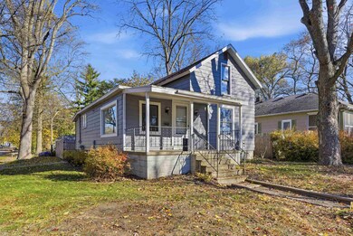
924 W Allen St Midland, MI 48640
Estimated payment $1,032/month
Highlights
- Main Floor Bedroom
- Corner Lot
- Porch
- Northeast Middle School Rated A-
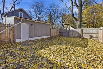
- Fenced Yard
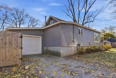
- 1 Car Attached Garage
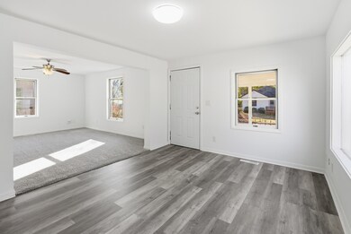
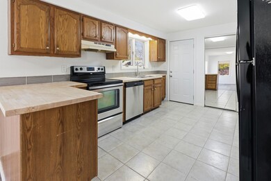
About This Home
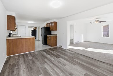
ALL YOU’VE EVER WANTED ON ALLEN STREET! This three bedroom, one bathroom bungalow is the epitome of charm meets functionable. With just over 1,000 square feet of living space and an additional full unfinished basement, your new home offers plenty of storage space! Built in 1925 on a lovely corner lot, this 1.5 story house is centrally located in Midland just minutes from the Ashman Circle with local shops and restaurants along with local entertainment like the Loons Stadium. Inside, the fresh paint on the walls and ceilings along with the new LVP flooring in the dining room and new carpet throughout the home give a clean slate for you to personalize to your liking. The spacious newly painted basement provides a new epoxy coated floor as well. An attached garage and spacious fenced back yard makes this house the perfect place for you to call home! Call today for your own private tour of 924 W Allen Street!
Open House Schedule
-
Saturday, November 15, 202511:00 am to 12:30 pm11/15/2025 11:00:00 AM +00:0011/15/2025 12:30:00 PM +00:00Add to Calendar
Home Details
Home Type
- Single Family
Est. Annual Taxes
Year Built
- Built in 1925
Lot Details
- 4,792 Sq Ft Lot
- Lot Dimensions are 50x100
- Fenced Yard
- Corner Lot
Home Design
- Bungalow
Interior Spaces
- 1,068 Sq Ft Home
- 1.5-Story Property
- Living Room
- Carpet
- Oven or Range
- Unfinished Basement
Bedrooms and Bathrooms
- 3 Bedrooms
- Main Floor Bedroom
- Bathroom on Main Level
- 1 Full Bathroom
Laundry
- Dryer
- Washer
Parking
- 1 Car Attached Garage
- Side Facing Garage
- Garage Door Opener
Outdoor Features
- Porch
Utilities
- Forced Air Heating and Cooling System
- Heating System Uses Natural Gas
- Gas Water Heater
Community Details
- Baker & Moss Subdivision
Listing and Financial Details
- Assessor Parcel Number 14-16-70-124
Map
Home Values in the Area
Average Home Value in this Area
Tax History
| Year | Tax Paid | Tax Assessment Tax Assessment Total Assessment is a certain percentage of the fair market value that is determined by local assessors to be the total taxable value of land and additions on the property. | Land | Improvement |
|---|---|---|---|---|
| 2025 | $2,384 | $64,900 | $0 | $0 |
| 2024 | $1,652 | $57,200 | $0 | $0 |
| 2023 | $1,573 | $49,900 | $0 | $0 |
| 2022 | $2,163 | $39,700 | $0 | $0 |
| 2021 | $2,074 | $35,200 | $0 | $0 |
| 2020 | $1,889 | $34,300 | $0 | $0 |
| 2019 | $1,843 | $34,200 | $7,500 | $26,700 |
| 2018 | $1,793 | $38,200 | $7,500 | $30,700 |
| 2017 | $0 | $33,100 | $7,500 | $25,600 |
| 2016 | $1,728 | $32,100 | $7,500 | $24,600 |
| 2012 | -- | $31,200 | $7,500 | $23,700 |
Property History
| Date | Event | Price | List to Sale | Price per Sq Ft |
|---|---|---|---|---|
| 11/13/2025 11/13/25 | For Sale | $158,500 | -- | $148 / Sq Ft |
Purchase History
| Date | Type | Sale Price | Title Company |
|---|---|---|---|
| Warranty Deed | $65,000 | None Available | |
| Warranty Deed | $65,000 | None Listed On Document |
Mortgage History
| Date | Status | Loan Amount | Loan Type |
|---|---|---|---|
| Open | $55,000 | Commercial | |
| Closed | $55,000 | New Conventional |
Source: Midland Board of REALTORS®
MLS Number: 50194199
APN: 14-16-70-124
Disclaimer: Certain information contained herein is derived from information provided by parties other than Homes.com. All information provided is deemed reliable, but is not guaranteed to be accurate and should be independently verified.
![]() IDX information is provided exclusively for personal, non-commercial use, and may not be used for any purpose other than to identify prospective properties consumers may be interested in purchasing. Information is deemed reliable but not guaranteed.
IDX information is provided exclusively for personal, non-commercial use, and may not be used for any purpose other than to identify prospective properties consumers may be interested in purchasing. Information is deemed reliable but not guaranteed.
- 1305 Noeske St
- 202 W Baker St
- 1711 Adelaide St
- 7 Brown Ct
- 201 E Carpenter St
- 119 E Hines St
- 1510 W Hines St
- 300 Richard Ct
- 1601 Bookness St
- 1112 Holyrood St
- 512 Townsend St
- 508 E Grove St
- 320 W Nickels St
- 201 E Ellsworth St Unit 302
- 803 E Carpenter St
- 2531 Jefferson Ave
- 2614 Jefferson Ave
- 3310 Noeske St
- 915 Elizabeth St
- 1508 W Carpenter St
- 401 E Hines St
- 3208 W Nelson St
- 2218 Jefferson Ave
- 2710 Jefferson Ave
- 217 Federal St
- 4900 Meyers St
- 1605 E Haley St
- 2414 Swede Ave
- 5111 Russell St
- 1524 Pheasant Ridge Dr
- 2211 Eastlawn Dr
- 1500 Wood Pointe Ln
- 6109 Summerset Dr
- 2514-2524 Bay City Rd
- 5524 Swede Ave
- 6222 Loretta Ln
- 837 Waldo Ave
- 4512 N Saginaw Rd
