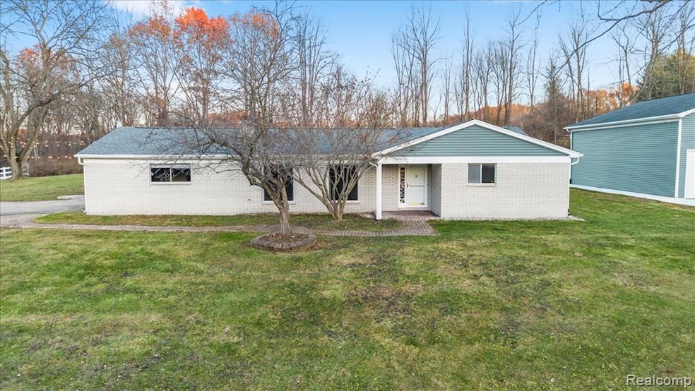


9240 Allen Rd Clarkston, MI 48348
Estimated payment $2,416/month
Highlights
- Popular Property
- Ranch Style House
- Ground Level Unit
- 1.09 Acre Lot
- Pole Barn
- Mud Room
About This Home
Your dream home just hit the market and is now at the top of your Christmas list. Welcome to this classic ranch style home that brings the ease of one level living and inviting spaces throughout. You are welcomed by a foyer and a living room with large windows that bring in natural light and a natural fireplace that anchors the space. The updated kitchen is great for entertaining with generous countertops and a built in drink tap that keeps your favorite beverage readily available and will be the talk of your housewarming celebration. Just beyond the kitchen is a flexible room that can serve as formal dining or an additional living area. The home features three bedrooms with the primary bedroom offering an attached bath. The laundry is located in the mudroom that leads to the insulated and heated two car garage which opens to a beautiful paver patio surrounded by extensive landscaping. The showstopper of the property is the well maintained heated outbuilding that is in excellent condition and offers incredible utility. It is also plumbed and connected to the septic system should someone wish to make further improvements. The large lot of just over an acre delivers a country feel while still offering the benefit of being close to town and expressways. This home is move in ready and offers immediate occupancy. Do not delay in scheduling your showing today.
Listing Agent
Berkshire Hathaway HomeServices Michigan Real Est License #6502370653 Listed on: 12/10/2025

Open House Schedule
-
Sunday, December 14, 202511:00 am to 1:00 pm12/14/2025 11:00:00 AM +00:0012/14/2025 1:00:00 PM +00:00Add to Calendar
Home Details
Home Type
- Single Family
Est. Annual Taxes
Year Built
- Built in 1969
Lot Details
- 1.09 Acre Lot
- Lot Dimensions are 237x200
- Dirt Road
Home Design
- Ranch Style House
- Brick Exterior Construction
- Slab Foundation
- Asphalt Roof
- Vinyl Construction Material
Interior Spaces
- 1,593 Sq Ft Home
- Bar Fridge
- Ceiling Fan
- Mud Room
- Great Room with Fireplace
Kitchen
- Free-Standing Gas Range
- Microwave
- Dishwasher
- Stainless Steel Appliances
Bedrooms and Bathrooms
- 3 Bedrooms
- 2 Full Bathrooms
Laundry
- Laundry Room
- Dryer
- Washer
Parking
- 2.5 Car Direct Access Garage
- Heated Garage
- Garage Door Opener
Outdoor Features
- Patio
- Exterior Lighting
- Pole Barn
Location
- Ground Level Unit
Utilities
- Forced Air Heating and Cooling System
- Heating System Uses Natural Gas
- Natural Gas Water Heater
- Water Softener is Owned
- High Speed Internet
Community Details
- No Home Owners Association
- Allen Woods Estates Subdivision
Listing and Financial Details
- Assessor Parcel Number 0808151001
Map
Home Values in the Area
Average Home Value in this Area
Tax History
| Year | Tax Paid | Tax Assessment Tax Assessment Total Assessment is a certain percentage of the fair market value that is determined by local assessors to be the total taxable value of land and additions on the property. | Land | Improvement |
|---|---|---|---|---|
| 2024 | $1,651 | $147,000 | $47,000 | $100,000 |
| 2023 | $2,226 | $123,400 | $45,000 | $78,400 |
| 2022 | $2,226 | $110,100 | $38,100 | $72,000 |
| 2021 | $2,226 | $105,500 | $38,100 | $67,400 |
| 2020 | $1,441 | $110,600 | $44,100 | $66,500 |
| 2018 | $2,125 | $103,300 | $44,600 | $58,700 |
| 2015 | -- | $67,800 | $0 | $0 |
| 2014 | -- | $67,800 | $0 | $0 |
| 2011 | -- | $62,000 | $0 | $0 |
Property History
| Date | Event | Price | List to Sale | Price per Sq Ft |
|---|---|---|---|---|
| 12/10/2025 12/10/25 | For Sale | $420,000 | -- | $264 / Sq Ft |
Purchase History
| Date | Type | Sale Price | Title Company |
|---|---|---|---|
| Quit Claim Deed | -- | None Available | |
| Sheriffs Deed | $138,521 | None Available | |
| Deed | -- | -- | |
| Deed | -- | -- | |
| Deed | -- | -- |
Mortgage History
| Date | Status | Loan Amount | Loan Type |
|---|---|---|---|
| Previous Owner | $110,000 | No Value Available |
Source: Realcomp
MLS Number: 20251059026
APN: 08-08-151-001
Disclaimer: Certain information contained herein is derived from information provided by parties other than Homes.com. All information provided is deemed reliable, but is not guaranteed to be accurate and should be independently verified.
![]() IDX provided courtesy of Realcomp II Ltd. via Ten-X and MLS
IDX provided courtesy of Realcomp II Ltd. via Ten-X and MLS
Copyright 2025 Realcomp II Ltd. Shareholders
IDX information is provided exclusively for consumers' personal, noncommercial use and may not be used for any purpose other than to identify prospective properties consumers may be interested in purchasing. The accuracy of all information, regardless of source, is not guaranteed or warranted. All information should be independently verified.
Listing Information presented by local MLS brokerage: Ten-X, local REALTOR®- Arlene Richardson - (888)-952-6393
- 9398 Ortonville Rd
- 8449 Allen Rd
- 00 Ortonville Rd
- 8573 Elkrun Dr
- 6595 Deer Ridge Dr
- 6571 Deer Ridge Dr
- 9551 Ellis Rd
- 8000 Barrington Ln Unit 3
- 00 Cranberry Lake Rd
- 00 Oakhill
- VL Clarkston Rd
- 8050 Ortonville Rd
- 8056 Ortonville Rd
- 6556 Amy Dr
- 7949 Bridge Valley
- 8179 Towering Pines Unit 6
- 0000 Bridge Lake Rd
- 8410 S Shore Dr Unit 29
- 7795 Fieldstone Ridge
- 3770 Reese Rd
- 8030 Reese Rd
- 8344 Ellis Rd
- 8054 Ortonville Rd
- 7244 Chapel View Dr
- 4000 Brookside Rd
- 8863 Dixie Hwy
- 74 S Holcomb Rd
- 495 W Seymour Lake Rd
- 6600 Trillium Village Ln Unit 23
- 5605 Parview Dr
- 3668 Willow Ct
- 3730 Birch St
- 3727 Birch St
- 3653 Pinoak St
- 5175 Parview Dr
- 3648 Chestnut St
- 5147 Lancaster Hills Dr
- 3678 Hawthorne St
- 3681 Hawthorne St
- 4421 Beechwood St