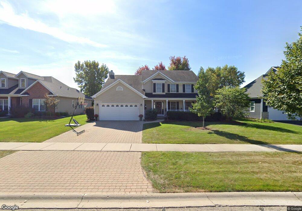
925 Independence Ave Elburn, IL 60119
Estimated Value: $484,951 - $573,000
4
Beds
3
Baths
2,540
Sq Ft
$204/Sq Ft
Est. Value
About This Home
This home is located at 925 Independence Ave, Elburn, IL 60119 and is currently estimated at $518,238, approximately $204 per square foot. 925 Independence Ave is a home located in Kane County with nearby schools including Kaneland Blackberry Creek Elementary School, Harter Middle School, and Kaneland High School.
Ownership History
Date
Name
Owned For
Owner Type
Purchase Details
Closed on
Aug 25, 2004
Sold by
Premier Home Builders Inc
Bought by
Roberts Joseph E and Roberts Nicole M
Current Estimated Value
Home Financials for this Owner
Home Financials are based on the most recent Mortgage that was taken out on this home.
Original Mortgage
$231,300
Outstanding Balance
$116,270
Interest Rate
6.1%
Mortgage Type
Purchase Money Mortgage
Estimated Equity
$401,968
Create a Home Valuation Report for This Property
The Home Valuation Report is an in-depth analysis detailing your home's value as well as a comparison with similar homes in the area
Home Values in the Area
Average Home Value in this Area
Purchase History
| Date | Buyer | Sale Price | Title Company |
|---|---|---|---|
| Roberts Joseph E | $310,500 | American Title |
Source: Public Records
Mortgage History
| Date | Status | Borrower | Loan Amount |
|---|---|---|---|
| Open | Roberts Joseph E | $231,300 |
Source: Public Records
Tax History
| Year | Tax Paid | Tax Assessment Tax Assessment Total Assessment is a certain percentage of the fair market value that is determined by local assessors to be the total taxable value of land and additions on the property. | Land | Improvement |
|---|---|---|---|---|
| 2024 | $10,797 | $133,778 | $17,164 | $116,614 |
| 2023 | $10,401 | $120,738 | $15,491 | $105,247 |
| 2022 | $9,633 | $107,278 | $14,217 | $93,061 |
| 2021 | $9,280 | $102,678 | $13,607 | $89,071 |
| 2020 | $9,110 | $100,271 | $13,288 | $86,983 |
| 2019 | $9,115 | $98,799 | $13,093 | $85,706 |
| 2018 | $9,450 | $100,351 | $13,093 | $87,258 |
| 2017 | $9,452 | $99,210 | $12,944 | $86,266 |
| 2016 | $9,640 | $98,437 | $12,602 | $85,835 |
| 2015 | -- | $90,439 | $8,711 | $81,728 |
| 2014 | -- | $83,529 | $11,167 | $72,362 |
| 2013 | -- | $83,529 | $11,167 | $72,362 |
Source: Public Records
Map
Nearby Homes
- 1557 Melbourne St
- 1171 Souders Ave
- 765 Carolyn Ct
- 931 Patriot Pkwy
- 801 Citizen Ave
- 1383 Dodson Ave
- 1106 Kendall St Unit 6
- 1038 Veteran Ave
- 1074 Freedom Rd
- 1076 Freedom Rd
- 980 Sears Cir
- 1123 Sears Cir
- 815 Kindberg Ct
- 1029 Wise St
- 713 Elizabeth St
- 671 Virginia St
- 607 Virginia St
- 16 Derek Dr
- 645 Virginia St
- 634 Virginia St
- 937 Independence Ave
- 913 Independence Ave Unit 2
- 949 Independence Ave
- 901 Independence Ave
- 924 Independence Ave Unit 924
- 924 Independence Ave Unit 1
- 924 Independence Ave
- 946 Independence Ave
- 946 Independence Ave
- 912 Independence Ave
- 951 Independence Ave
- 885 Independence Ave Unit 2
- 900 Independence Ave
- 968 Independence Ave
- 861 Independence Ave
- 1583 Melbourne St
- 1571 Melbourne St
- 847 Independence Ave Unit 2
- 18 Hughes Rd
- 1543 Melbourne St Unit 2
Your Personal Tour Guide
Ask me questions while you tour the home.