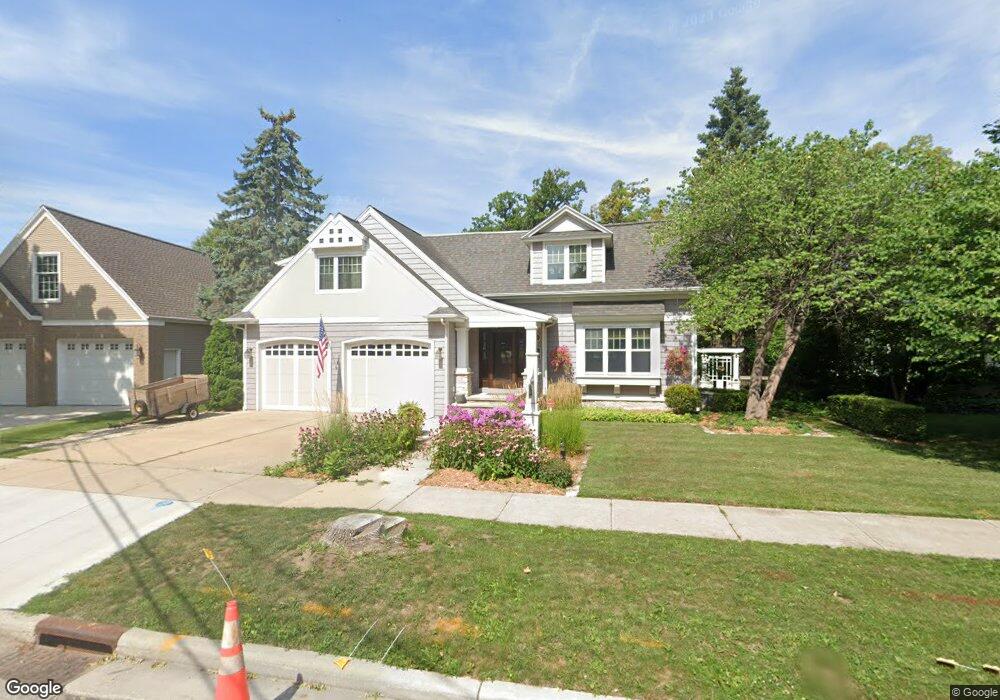
926 Fox River Dr de Pere, WI 54115
Estimated Value: $652,000 - $1,254,000
3
Beds
3
Baths
4,130
Sq Ft
$236/Sq Ft
Est. Value
About This Home
This home is located at 926 Fox River Dr, de Pere, WI 54115 and is currently estimated at $973,950, approximately $235 per square foot. 926 Fox River Dr is a home located in Brown County with nearby schools including Susie C. Altmayer Elementary School, Foxview Intermediate School, and De Pere Middle School.
Ownership History
Date
Name
Owned For
Owner Type
Purchase Details
Closed on
Dec 5, 2006
Sold by
Lasecki Kim L and Lasecki Cynthia M
Bought by
The Kim & Cynthia Lasecki Revocable Tr
Current Estimated Value
Purchase Details
Closed on
Jul 9, 2001
Sold by
Uchtman Edwin Richard and Kume Allyson Chitose
Bought by
Lasecki Kim L and Lasecki Cynthia M
Home Financials for this Owner
Home Financials are based on the most recent Mortgage that was taken out on this home.
Original Mortgage
$265,500
Interest Rate
7.22%
Create a Home Valuation Report for This Property
The Home Valuation Report is an in-depth analysis detailing your home's value as well as a comparison with similar homes in the area
Home Values in the Area
Average Home Value in this Area
Purchase History
| Date | Buyer | Sale Price | Title Company |
|---|---|---|---|
| The Kim & Cynthia Lasecki Revocable Tr | -- | Liberty Title | |
| Lasecki Kim L | $430,000 | Gb Title |
Source: Public Records
Mortgage History
| Date | Status | Borrower | Loan Amount |
|---|---|---|---|
| Previous Owner | Lasecki Kim L | $265,500 | |
| Closed | Lasecki Kim L | $100,000 |
Source: Public Records
Tax History Compared to Growth
Tax History
| Year | Tax Paid | Tax Assessment Tax Assessment Total Assessment is a certain percentage of the fair market value that is determined by local assessors to be the total taxable value of land and additions on the property. | Land | Improvement |
|---|---|---|---|---|
| 2024 | $13,234 | $905,100 | $331,200 | $573,900 |
| 2023 | $12,051 | $856,900 | $331,200 | $525,700 |
| 2022 | $11,848 | $802,200 | $276,500 | $525,700 |
| 2021 | $10,615 | $679,500 | $230,400 | $449,100 |
| 2020 | $11,334 | $679,500 | $230,400 | $449,100 |
| 2019 | $12,300 | $660,300 | $211,200 | $449,100 |
| 2018 | $12,687 | $619,500 | $211,200 | $408,300 |
| 2017 | $12,534 | $600,300 | $192,000 | $408,300 |
| 2016 | $12,784 | $600,300 | $192,000 | $408,300 |
| 2015 | $12,747 | $590,900 | $192,000 | $398,900 |
| 2014 | $12,980 | $590,900 | $192,000 | $398,900 |
| 2013 | $12,980 | $590,900 | $192,000 | $398,900 |
Source: Public Records
Map
Nearby Homes
- 830 S Superior St Unit 832
- 717 4th St
- 806 4th St
- 416 Lansdowne St
- 410 Battery Ave
- 363 Battery Ave
- 1611 N Honeysuckle Cir
- 305 Battery Ave
- 385 Battery Ave
- 413 Brookline Ave
- 337 Battery Ave
- 400 Battery Ave
- 200 William St Unit 402
- 1004 Gulfstream Ct
- 318 S Webster Ave
- 555 Main Ave Unit 110
- 555 Main Ave Unit 104
- 555 Main Ave Unit 111
- 555 Main Ave Unit 206
- 555 Main Ave Unit 113
- 1000 Fox River Dr
- 918 Fox River Dr
- 900 900 Fox River Dr
- 1012 Fox River Dr
- 838 Fox River Dr
- 927 Fox River Dr
- 1011 Fox River Dr
- 1024 Fox River Dr
- 1025 Fox River Dr
- 832 Fox River Dr
- 903 Fox River Dr
- 833 Fox River Dr
- 1106 Fox River Dr
- 918 Georgia Dr
- 820 Fox River Dr
- 912 Georgia Dr
- 1000 Georgia Dr
- 425 Cook St
- 400 Cook St
- 906 Georgia Dr