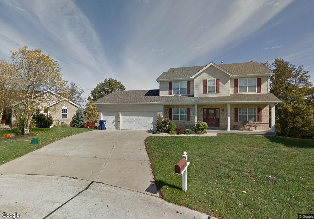
926 Hampshire Heath Dr O Fallon, MO 63368
Estimated Value: $464,000 - $501,000
4
Beds
4
Baths
2,557
Sq Ft
$187/Sq Ft
Est. Value
About This Home
This home is located at 926 Hampshire Heath Dr, O Fallon, MO 63368 and is currently estimated at $478,005, approximately $186 per square foot. 926 Hampshire Heath Dr is a home located in St. Charles County with nearby schools including G.L. Priess Primary School, Quest Elementary School, and Prairie View Elementary School.
Ownership History
Date
Name
Owned For
Owner Type
Purchase Details
Closed on
Sep 15, 2005
Sold by
Haefner Steven P and Haefner Debra E
Bought by
Hollensbe Richard Forrest and Hollensbe Jayne M
Current Estimated Value
Home Financials for this Owner
Home Financials are based on the most recent Mortgage that was taken out on this home.
Original Mortgage
$202,000
Outstanding Balance
$107,459
Interest Rate
5.76%
Mortgage Type
Fannie Mae Freddie Mac
Estimated Equity
$370,546
Purchase Details
Closed on
Jul 25, 2001
Sold by
Casper Homes & Development Co
Bought by
Haefner Steven P and Haefner Debra E
Home Financials for this Owner
Home Financials are based on the most recent Mortgage that was taken out on this home.
Original Mortgage
$202,999
Interest Rate
7.07%
Mortgage Type
VA
Create a Home Valuation Report for This Property
The Home Valuation Report is an in-depth analysis detailing your home's value as well as a comparison with similar homes in the area
Home Values in the Area
Average Home Value in this Area
Purchase History
| Date | Buyer | Sale Price | Title Company |
|---|---|---|---|
| Hollensbe Richard Forrest | $252,500 | Inv | |
| Haefner Steven P | -- | -- |
Source: Public Records
Mortgage History
| Date | Status | Borrower | Loan Amount |
|---|---|---|---|
| Open | Hollensbe Richard Forrest | $202,000 | |
| Previous Owner | Haefner Steven P | $202,999 |
Source: Public Records
Tax History Compared to Growth
Tax History
| Year | Tax Paid | Tax Assessment Tax Assessment Total Assessment is a certain percentage of the fair market value that is determined by local assessors to be the total taxable value of land and additions on the property. | Land | Improvement |
|---|---|---|---|---|
| 2025 | $4,574 | $78,887 | -- | -- |
| 2023 | $4,574 | $71,196 | $0 | $0 |
| 2022 | $4,035 | $58,560 | $0 | $0 |
| 2021 | $4,039 | $58,560 | $0 | $0 |
| 2020 | $3,818 | $53,096 | $0 | $0 |
| 2019 | $3,548 | $53,096 | $0 | $0 |
| 2018 | $3,789 | $54,053 | $0 | $0 |
| 2017 | $3,789 | $54,053 | $0 | $0 |
| 2016 | $3,337 | $45,610 | $0 | $0 |
| 2015 | $3,294 | $45,610 | $0 | $0 |
| 2014 | $3,149 | $46,707 | $0 | $0 |
Source: Public Records
Map
Nearby Homes
- 804 Brockwell Dr
- 842 Brockwell Dr
- The Carlton II Plan at Inverness
- The Stansbury II Plan at Inverness
- The Berkshire II Plan at Inverness
- The Bellwynn Plan at Inverness
- The Carlton Plan at Inverness
- The Berkshire Plan at Inverness
- The Glenwyck II Plan at Inverness
- The Stansbury Plan at Inverness
- The Vanguard II Plan at Inverness
- The Rochester Plan at Inverness
- The Bellwynn II Plan at Inverness
- The Glenwyck Plan at Inverness
- The Vanguard Plan at Inverness
- The Rochester II Plan at Inverness
- 662 Knollshire Way
- 11 Warchol Ct
- 142 Royal Troon Dr
- 243 Greenshire Ln