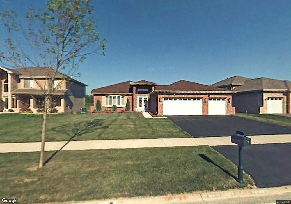
927 Destiny Dr Matteson, IL 60443
West Matteson NeighborhoodEstimated Value: $379,727 - $430,000
3
Beds
3
Baths
2,300
Sq Ft
$178/Sq Ft
Est. Value
About This Home
This home is located at 927 Destiny Dr, Matteson, IL 60443 and is currently estimated at $409,182, approximately $177 per square foot. 927 Destiny Dr is a home located in Cook County with nearby schools including Colin Powell Middle School.
Ownership History
Date
Name
Owned For
Owner Type
Purchase Details
Closed on
Oct 19, 2021
Sold by
Mitchell Judson C and Mitchell Diane L
Bought by
Mitchell Judson C and Hodges Diane L
Current Estimated Value
Home Financials for this Owner
Home Financials are based on the most recent Mortgage that was taken out on this home.
Original Mortgage
$161,000
Interest Rate
3.85%
Mortgage Type
New Conventional
Purchase Details
Closed on
Feb 20, 2007
Sold by
Mitchell Judson and Hodges Diane
Bought by
Mitchell Judson C and Hodges Diane L
Purchase Details
Closed on
May 12, 2006
Sold by
First Midwest Bank
Bought by
Mitchell Judson and Hodges Diane
Home Financials for this Owner
Home Financials are based on the most recent Mortgage that was taken out on this home.
Original Mortgage
$176,000
Interest Rate
6.54%
Mortgage Type
Fannie Mae Freddie Mac
Create a Home Valuation Report for This Property
The Home Valuation Report is an in-depth analysis detailing your home's value as well as a comparison with similar homes in the area
Home Values in the Area
Average Home Value in this Area
Purchase History
| Date | Buyer | Sale Price | Title Company |
|---|---|---|---|
| Mitchell Judson C | -- | None Listed On Document | |
| Mitchell Judson C | -- | None Listed On Document | |
| Mitchell Judson C | -- | None Available | |
| Mitchell Judson | $322,500 | Cti |
Source: Public Records
Mortgage History
| Date | Status | Borrower | Loan Amount |
|---|---|---|---|
| Previous Owner | Mitchell Judson C | $161,000 | |
| Previous Owner | Mitchell Judson | $176,000 |
Source: Public Records
Tax History
| Year | Tax Paid | Tax Assessment Tax Assessment Total Assessment is a certain percentage of the fair market value that is determined by local assessors to be the total taxable value of land and additions on the property. | Land | Improvement |
|---|---|---|---|---|
| 2025 | $11,206 | $33,000 | $4,930 | $28,070 |
| 2024 | $11,206 | $33,000 | $4,930 | $28,070 |
| 2023 | $8,664 | $33,000 | $4,930 | $28,070 |
| 2022 | $8,664 | $22,341 | $4,314 | $18,027 |
| 2021 | $8,833 | $22,339 | $4,313 | $18,026 |
| 2020 | $8,750 | $22,339 | $4,313 | $18,026 |
| 2019 | $9,373 | $23,327 | $4,005 | $19,322 |
| 2018 | $9,231 | $23,327 | $4,005 | $19,322 |
| 2017 | $9,032 | $23,327 | $4,005 | $19,322 |
| 2016 | $8,310 | $20,339 | $3,697 | $16,642 |
| 2015 | $8,050 | $20,339 | $3,697 | $16,642 |
| 2014 | $8,902 | $22,411 | $3,697 | $18,714 |
| 2013 | $9,150 | $24,397 | $3,697 | $20,700 |
Source: Public Records
Map
Nearby Homes
- 1010 Regent Dr
- 997 Regent Dr
- 912 Princeton Ave
- 21131 Vivienne Dr
- 6216 Pond View Dr
- 829 Princeton Ave
- 21156 Christina Dr
- 5631 Colgate Ln
- 21206 Sophia Dr
- 6125 Sunflower Dr
- 6158 White Birch Ln
- 6021 Spring Ln
- 5503 Georgetown Dr
- 6037 Spring Ln
- 21218 Shannon Ave
- 21143 Gray Hawk Dr Unit 2554
- 6306 Beaver Dam Rd
- 0 Ridgeland Ave
- 6503 Blue Sky Ln Unit 2502
- 6500 Pasture Side Trail
Your Personal Tour Guide
Ask me questions while you tour the home.