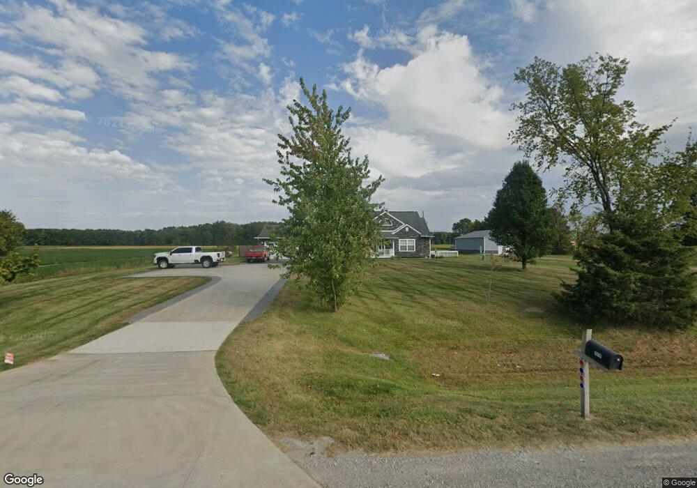
9274 Sheridan Rd New Lothrop, MI 48460
Estimated Value: $273,000 - $462,808
3
Beds
2
Baths
2,307
Sq Ft
$169/Sq Ft
Est. Value
About This Home
This home is located at 9274 Sheridan Rd, New Lothrop, MI 48460 and is currently estimated at $390,702, approximately $169 per square foot. 9274 Sheridan Rd is a home located in Genesee County with nearby schools including Carter Elementary School, Kuehn-Haven Middle School, and Hill-McCloy High School.
Ownership History
Date
Name
Owned For
Owner Type
Purchase Details
Closed on
Jul 20, 2011
Sold by
Us Bank National Association
Bought by
Moore Lacey A
Current Estimated Value
Home Financials for this Owner
Home Financials are based on the most recent Mortgage that was taken out on this home.
Original Mortgage
$115,700
Outstanding Balance
$79,748
Interest Rate
4.55%
Mortgage Type
New Conventional
Estimated Equity
$310,954
Purchase Details
Closed on
May 19, 2010
Sold by
Corcoran David M and Penney Alisha
Bought by
U S Bank National Association
Purchase Details
Closed on
Mar 30, 2007
Sold by
Corcoran David M
Bought by
Corcoran David M and Penney Alisha
Create a Home Valuation Report for This Property
The Home Valuation Report is an in-depth analysis detailing your home's value as well as a comparison with similar homes in the area
Home Values in the Area
Average Home Value in this Area
Purchase History
| Date | Buyer | Sale Price | Title Company |
|---|---|---|---|
| Moore Lacey A | $115,700 | Garrow Title Agency Llc | |
| U S Bank National Association | $86,797 | None Available | |
| Corcoran David M | -- | Guaranty Title Company |
Source: Public Records
Mortgage History
| Date | Status | Borrower | Loan Amount |
|---|---|---|---|
| Open | Moore Lacey A | $115,700 |
Source: Public Records
Tax History Compared to Growth
Tax History
| Year | Tax Paid | Tax Assessment Tax Assessment Total Assessment is a certain percentage of the fair market value that is determined by local assessors to be the total taxable value of land and additions on the property. | Land | Improvement |
|---|---|---|---|---|
| 2025 | $5,215 | $210,000 | $0 | $0 |
| 2024 | $1,509 | $209,600 | $0 | $0 |
| 2023 | $1,440 | $194,200 | $0 | $0 |
| 2022 | $4,748 | $185,100 | $0 | $0 |
| 2021 | $4,625 | $157,400 | $0 | $0 |
| 2020 | $1,262 | $144,200 | $0 | $0 |
| 2019 | $1,242 | $135,600 | $0 | $0 |
| 2018 | $4,098 | $108,700 | $0 | $0 |
| 2017 | $3,146 | $108,700 | $0 | $0 |
| 2016 | $3,123 | $99,300 | $0 | $0 |
| 2015 | $2,921 | $95,800 | $0 | $0 |
| 2014 | $936 | $93,900 | $0 | $0 |
| 2012 | -- | $78,200 | $78,200 | $0 |
Source: Public Records
Map
Nearby Homes
- 9197 Sheridan Rd
- 9157 Duffield Rd
- 8425 Duffield Rd
- 8506 Duffield Rd
- 8498 Duffield Rd
- 8366 Byron Rd
- 8073 Nichols Rd
- 11348 Duffield Rd
- 10456 Nichols Rd
- 12374 Stanley Rd
- 10195 Dodge Rd
- 10187 Dodge Rd
- 11435 Duffield Rd
- 9464 Beech St
- 7493 S Saginaw St
- 10028 Mcafee Rd
- 9456 Genesee St
- 000 W Dodge Rd
- 11067 Seymour Rd
- 11186 W Stanley Rd
- 9260 Sheridan Rd
- 14454 Sheridan Rd
- 14054 Sheridan Rd
- 0 Sheridan Rd
- 9322 Sheridan Rd
- 9198 Sheridan Rd
- 9198 Sheridan Rd
- 9361 Sheridan Rd
- 9161 Sheridan Rd
- 9405 Sheridan Rd
- 12245 Dodge Rd
- 12199 W Dodge Rd
- 12165 Dodge Rd
- 12440 Dodge Rd
- 1010 Ditch Rd
- 10020 Sheridan Rd
- 12199 Dodge Rd
- 1169 Ditch Rd
- 1165 Ditch Rd
- 12308 Frances Rd