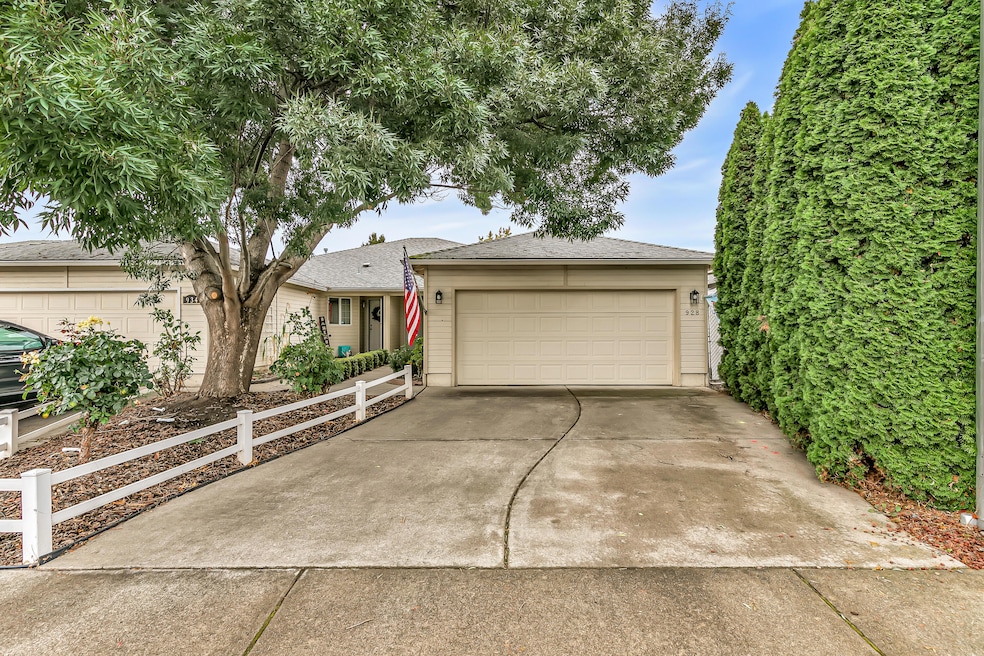
928 Brandi Way Central Point, OR 97502
Estimated payment $1,989/month
Highlights
- Traditional Architecture
- No HOA
- Eat-In Kitchen
- Engineered Wood Flooring
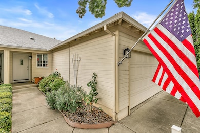
- 1 Car Attached Garage
- 5-minute walk to B.F Egypt
About This Home
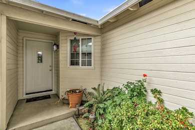
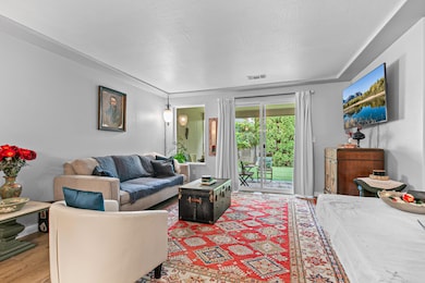
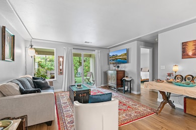
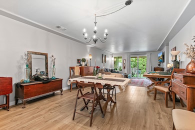
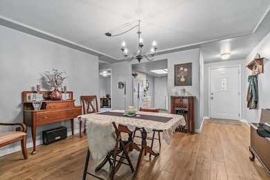
Welcome to this charming and well-maintained three-bedroom, two-bath home that perfectly blends comfort and convenience. Nestled in a quiet neighborhood, this single-side duplex is ideal for first-time buyers, downsizers, or anyone looking for a move-in-ready property with thoughtful upgrades. Step inside to discover brand-new flooring that flows seamlessly throughout the main living areas, creating a clean and modern feel. The spacious kitchen offers ample cabinet storage, making it both functional and practical for everyday living or entertaining. With no HOA fees and a low-maintenance yard, this home is perfect for those with a busy lifestyle looking for hassle-free living. Call today to schedule your private tour!

Home Details
Home Type
- Single Family
Est. Annual Taxes
- $3,049
Year Built
- Built in 1998
Lot Details
- 3,485 Sq Ft Lot
- Property is zoned R-3, R-3
Parking
- 1 Car Attached Garage
- Garage Door Opener
- Driveway
Home Design
- Traditional Architecture
- Frame Construction
- Composition Roof
- Concrete Perimeter Foundation
Interior Spaces
- 1,311 Sq Ft Home
- 1-Story Property
- Vinyl Clad Windows
- Living Room
- Engineered Wood Flooring
- Eat-In Kitchen
Bedrooms and Bathrooms
- 3 Bedrooms
- 2 Full Bathrooms
Home Security
- Carbon Monoxide Detectors
- Fire and Smoke Detector
Schools
- Central Point Elementary School
- Scenic Middle School
- Crater High School
Utilities
- Forced Air Heating and Cooling System
- Natural Gas Connected
- Phone Available
- Cable TV Available
Community Details
- No Home Owners Association
- Forest Glen Phase I Subdivision
Listing and Financial Details
- Exclusions: Portable fireplace in guest bedroom.
- Assessor Parcel Number 10907505
Map
Home Values in the Area
Average Home Value in this Area
Tax History
| Year | Tax Paid | Tax Assessment Tax Assessment Total Assessment is a certain percentage of the fair market value that is determined by local assessors to be the total taxable value of land and additions on the property. | Land | Improvement |
|---|---|---|---|---|
| 2025 | $2,975 | $178,910 | $27,310 | $151,600 |
| 2024 | $2,975 | $173,700 | $26,520 | $147,180 |
| 2023 | $2,879 | $168,650 | $25,750 | $142,900 |
| 2022 | $2,812 | $168,650 | $25,750 | $142,900 |
| 2021 | $2,732 | $163,740 | $25,000 | $138,740 |
| 2020 | $2,652 | $158,980 | $24,280 | $134,700 |
| 2019 | $2,586 | $149,860 | $22,880 | $126,980 |
| 2018 | $2,508 | $145,500 | $22,210 | $123,290 |
| 2017 | $2,445 | $145,500 | $22,210 | $123,290 |
| 2016 | $2,373 | $137,160 | $20,940 | $116,220 |
| 2015 | $2,221 | $133,480 | $20,930 | $112,550 |
| 2014 | $2,123 | $129,300 | $19,740 | $109,560 |
Property History
| Date | Event | Price | List to Sale | Price per Sq Ft |
|---|---|---|---|---|
| 10/16/2025 10/16/25 | For Sale | $329,900 | -- | $252 / Sq Ft |
Purchase History
| Date | Type | Sale Price | Title Company |
|---|---|---|---|
| Interfamily Deed Transfer | -- | None Available | |
| Warranty Deed | $88,600 | Amerititle |
Mortgage History
| Date | Status | Loan Amount | Loan Type |
|---|---|---|---|
| Open | $88,037 | FHA |
Source: Oregon Datashare
MLS Number: 220210731
APN: 10907505
Disclaimer: Certain information contained herein is derived from information provided by parties other than Homes.com. All information provided is deemed reliable, but is not guaranteed to be accurate and should be independently verified.
![]() © 2025 Oregon Datashare (KCAR | MLSCO | SOMLS). All rights reserved. The data relating to real estate for sale on this web site comes in part from the Internet Data Exchange Program of the Oregon Datashare. Real estate listings held by IDX Brokerage firms other than Ten-X are marked with the Internet Data Exchange logo or the Internet Data Exchange thumbnail logo and detailed information about them includes the name of the listing Brokers. Information provided is for consumers' personal, non-commercial use and may not be used for any purpose other than to identify prospective properties the viewer may be interested in purchasing. The consumer will not copy, retransmit nor redistribute any of the content from this website. Information provided is deemed reliable, but not guaranteed.
© 2025 Oregon Datashare (KCAR | MLSCO | SOMLS). All rights reserved. The data relating to real estate for sale on this web site comes in part from the Internet Data Exchange Program of the Oregon Datashare. Real estate listings held by IDX Brokerage firms other than Ten-X are marked with the Internet Data Exchange logo or the Internet Data Exchange thumbnail logo and detailed information about them includes the name of the listing Brokers. Information provided is for consumers' personal, non-commercial use and may not be used for any purpose other than to identify prospective properties the viewer may be interested in purchasing. The consumer will not copy, retransmit nor redistribute any of the content from this website. Information provided is deemed reliable, but not guaranteed.
- 1060 Hopkins Rd
- 1017 Fairfield Ave
- 851 Juanita Way
- 1132 Hampton Dr
- 571 Briarwood Dr
- 1006 Forest Glen Dr
- 460 Federal Way
- 3496 Edella St
- 881 Westrop Dr
- 301 Freeman Rd Unit 100
- 301 Freeman Rd Unit 31
- 301 Freeman Rd Unit 23
- 301 Freeman Rd Unit 85
- 230 Peninger Rd
- 555 Freeman Rd Unit 128
- 555 Freeman Rd Unit 146
- 555 Freeman Rd Unit 85
- 555 Freeman Rd Unit 204
- 555 Freeman Rd Unit 136
- 555 Freeman Rd Unit 209
- 1125 Annalise St
- 700 N Haskell St
- 2190 Poplar Dr
- 1801 Poplar Dr
- 237 E McAndrews Rd
- 302 Maple St Unit 4
- 645 Royal Ave
- 520 N Bartlett St
- 518 N Riverside Ave
- 2642 W Main St
- 835 Overcup St
- 406 W Main St
- 121 S Holly St
- 230 Laurel St
- 309 Laurel St
- 534 Hamilton St Unit 534
- 1661 S Columbus Ave
- 7435 Denman Ct
- 353 Dalton St
- 322 Lorraine Ave Unit A