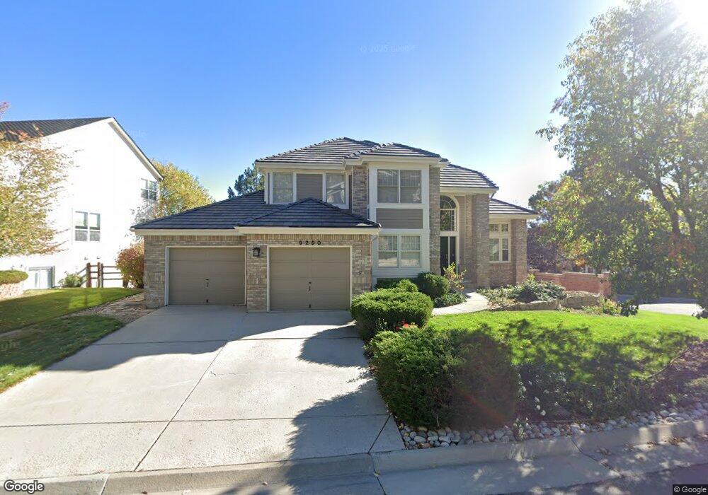
9290 Bauer Ct Lone Tree, CO 80124
Estimated Value: $798,223 - $935,000
3
Beds
4
Baths
2,604
Sq Ft
$330/Sq Ft
Est. Value
About This Home
This home is located at 9290 Bauer Ct, Lone Tree, CO 80124 and is currently estimated at $859,056, approximately $329 per square foot. 9290 Bauer Ct is a home located in Douglas County with nearby schools including Eagle Ridge Elementary School, Cresthill Middle School, and Highlands Ranch High School.
Ownership History
Date
Name
Owned For
Owner Type
Purchase Details
Closed on
Aug 4, 2009
Sold by
Molny David J
Bought by
Molny Cindy
Current Estimated Value
Purchase Details
Closed on
Feb 9, 1995
Sold by
Henry Nelson L and Henry Rowene L
Bought by
Molny David J and Molny Cindy M
Home Financials for this Owner
Home Financials are based on the most recent Mortgage that was taken out on this home.
Original Mortgage
$220,000
Interest Rate
8.5%
Purchase Details
Closed on
Dec 20, 1993
Sold by
Emerald On The Green Ltd Partnership
Bought by
Henry Nelson L and Henry Rowene L
Home Financials for this Owner
Home Financials are based on the most recent Mortgage that was taken out on this home.
Original Mortgage
$214,500
Interest Rate
4.5%
Purchase Details
Closed on
Dec 24, 1992
Sold by
Mdt Ltd
Bought by
Emerald On The Green Ltd
Create a Home Valuation Report for This Property
The Home Valuation Report is an in-depth analysis detailing your home's value as well as a comparison with similar homes in the area
Home Values in the Area
Average Home Value in this Area
Purchase History
| Date | Buyer | Sale Price | Title Company |
|---|---|---|---|
| Molny Cindy | -- | None Available | |
| Molny David J | $275,000 | Land Title | |
| Henry Nelson L | $268,833 | Land Title | |
| Emerald On The Green Ltd | $175,000 | -- |
Source: Public Records
Mortgage History
| Date | Status | Borrower | Loan Amount |
|---|---|---|---|
| Closed | Molny David J | $220,000 | |
| Previous Owner | Henry Nelson L | $214,500 |
Source: Public Records
Tax History
| Year | Tax Paid | Tax Assessment Tax Assessment Total Assessment is a certain percentage of the fair market value that is determined by local assessors to be the total taxable value of land and additions on the property. | Land | Improvement |
|---|---|---|---|---|
| 2025 | $4,310 | $50,130 | $10,790 | $39,340 |
| 2024 | $4,310 | $56,400 | $12,360 | $44,040 |
| 2023 | $4,354 | $56,400 | $12,360 | $44,040 |
| 2022 | $3,784 | $41,610 | $8,980 | $32,630 |
| 2021 | $3,935 | $41,610 | $8,980 | $32,630 |
| 2020 | $3,877 | $42,010 | $8,600 | $33,410 |
| 2019 | $3,889 | $42,010 | $8,600 | $33,410 |
| 2018 | $3,190 | $36,850 | $8,290 | $28,560 |
| 2017 | $3,241 | $36,850 | $8,290 | $28,560 |
| 2016 | $3,187 | $35,500 | $8,160 | $27,340 |
| 2015 | $1,629 | $35,500 | $8,160 | $27,340 |
| 2014 | $1,443 | $29,490 | $6,370 | $23,120 |
Source: Public Records
Map
Nearby Homes
- 9320 Miles Dr
- 8159 Lodgepole Trail
- 8666 Ainsdale Ct Unit 12B
- 8049 Sweet Water Rd
- 8356 Green Island Cir
- 8555 Green Island Cir
- 8822 Fiesta Terrace
- 8870 Fiesta Terrace
- 8860 Kachina Way
- 9631 Kemper Dr
- 789 Mercury Cir
- 7459 La Quinta Place
- 9835 Firestone Cir
- 9314 Wiltshire Dr
- 9329 E Star Hill Trail
- 9873 Greensview Cir
- 9466 Wiltshire Dr
- 9853 Greensview Cir
- 130 Dianna Dr
- 13226 Canopus Dr
- 9278 Bauer Ct
- 9310 Bauer Ct Unit 4
- 9272 Meredith Ct
- 9266 Bauer Ct
- 9300 Miles Dr
- 9308 Miles Dr Unit 45
- 9312 Miles Dr Unit 4
- 9314 Bauer Ct Unit 3
- 9316 Miles Dr
- 9276 Miles Dr
- 9304 Miles Dr Unit 6
- 9318 Bauer Ct Unit 2
- 9324 Miles Dr
- 9268 Miles Dr Unit 3
- 9320 Meredith Ct Unit 1
- 9272 Miles Dr
- 9258 Meredith Ct
- 9322 Bauer Ct Unit 1
- 9264 Miles Dr Unit 4
- 9312 Meredith Ct Unit 3
Your Personal Tour Guide
Ask me questions while you tour the home.