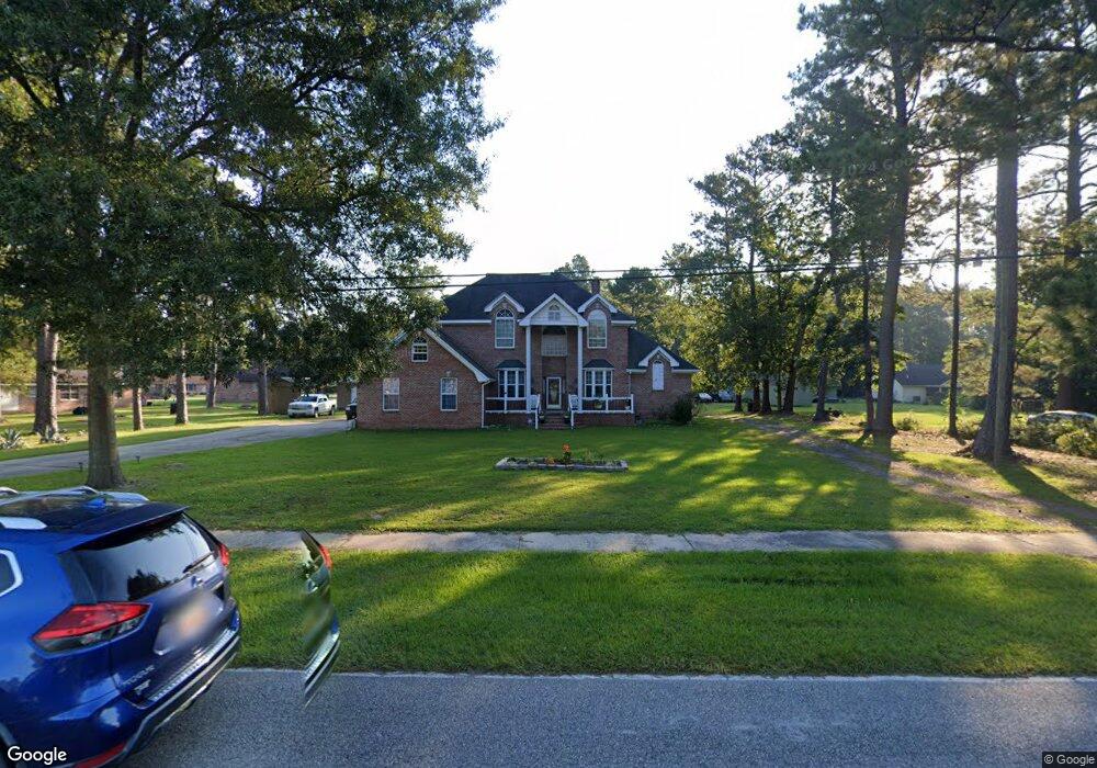
932 McDonald Rd Georgetown, SC 29440
Estimated Value: $306,000 - $491,228
4
Beds
4
Baths
3,540
Sq Ft
$111/Sq Ft
Est. Value
About This Home
This home is located at 932 McDonald Rd, Georgetown, SC 29440 and is currently estimated at $392,807, approximately $110 per square foot. 932 McDonald Rd is a home located in Georgetown County with nearby schools including McDonald Elementary School, Georgetown Middle School, and Georgetown High School.
Ownership History
Date
Name
Owned For
Owner Type
Purchase Details
Closed on
Aug 13, 2014
Sold by
Fannie Mae
Bought by
Bateman Frank and Bateman Gloria J
Current Estimated Value
Purchase Details
Closed on
Jul 24, 2013
Sold by
Sanders Mildred T
Bought by
Federal National Mortgage Association
Purchase Details
Closed on
Jun 19, 2000
Sold by
Knowlin Eva
Bought by
Sanders Clarence and Sanders Mildred T
Create a Home Valuation Report for This Property
The Home Valuation Report is an in-depth analysis detailing your home's value as well as a comparison with similar homes in the area
Purchase History
| Date | Buyer | Sale Price | Title Company |
|---|---|---|---|
| Bateman Frank | -- | -- | |
| Federal National Mortgage Association | $255,210 | -- | |
| Sanders Clarence | $30,000 | -- |
Source: Public Records
Tax History Compared to Growth
Tax History
| Year | Tax Paid | Tax Assessment Tax Assessment Total Assessment is a certain percentage of the fair market value that is determined by local assessors to be the total taxable value of land and additions on the property. | Land | Improvement |
|---|---|---|---|---|
| 2024 | $1,225 | $9,100 | $1,050 | $8,050 |
| 2023 | $1,120 | $9,100 | $1,050 | $8,050 |
| 2022 | $1,039 | $9,100 | $1,050 | $8,050 |
| 2021 | $1,270 | $9,104 | $1,052 | $8,052 |
| 2020 | $1,267 | $9,104 | $1,052 | $8,052 |
| 2019 | $1,234 | $8,900 | $1,052 | $7,848 |
| 2018 | $1,260 | $89,000 | $0 | $0 |
| 2017 | $1,077 | $88,960 | $0 | $0 |
| 2016 | $1,063 | $8,896 | $0 | $0 |
| 2015 | $1,456 | $0 | $0 | $0 |
| 2014 | $1,456 | $353,600 | $26,300 | $327,300 |
| 2012 | -- | $353,600 | $26,300 | $327,300 |
Source: Public Records
Map
Nearby Homes
- 480 Lincolnshire Dr
- 663 Player St
- 1939 Mauricena Rd
- 345 Player St
- 205 Glenda Loop
- 233 Glenda Loop
- 85 Graham Ln
- 54 Juniper Place
- 210 County Road S-22-577
- 84 Greentown Rd
- 3240 Highmarket St
- 621 Garden Ave
- 607 Garden Ave
- 2527 Highmarket St
- 459 Garden Ave
- 2416 Prince St
- 5266 Highmarket St
- 0 Rainey Dr
- 2004 Seitter St
- 1841 Jasper St
- 902 McDonald Rd
- tbd Savannah Bluff Rd Unit LOT 4
- tbd Savannah Bluff Rd Unit LOT 5
- 475 Yadkin Ave
- 255 Savannah St
- 467 Yadkin Ave
- 435 Yadkin Ave
- 927 McDonald Rd
- 927 McDonald Rd
- 983 McDonald Rd
- 913 McDonald Rd
- 235 Savannah St
- 239 Savannah St
- 931 McDonald Rd
- 965 McDonald Rd
- 880 McDonald Rd
- 225 Savannah St
- 994 McDonald Rd
- 391 Yadkin Ave
- 1013 McDonald Rd