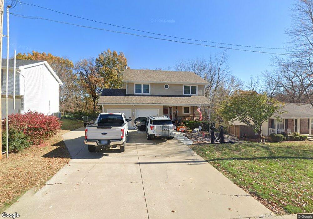
932 N 4th St Lansing, KS 66043
Estimated Value: $273,000 - $384,000
3
Beds
3
Baths
1,934
Sq Ft
$162/Sq Ft
Est. Value
About This Home
This home is located at 932 N 4th St, Lansing, KS 66043 and is currently estimated at $312,355, approximately $161 per square foot. 932 N 4th St is a home located in Leavenworth County with nearby schools including Lansing Elementary School, Lansing Middle 6-8, and Lansing High 9-12.
Ownership History
Date
Name
Owned For
Owner Type
Purchase Details
Closed on
Jun 1, 1990
Bought by
Hileman Milton M and Hileman Holly A
Current Estimated Value
Home Financials for this Owner
Home Financials are based on the most recent Mortgage that was taken out on this home.
Original Mortgage
$110,327
Outstanding Balance
$1,919
Interest Rate
10.29%
Mortgage Type
New Conventional
Estimated Equity
$310,436
Create a Home Valuation Report for This Property
The Home Valuation Report is an in-depth analysis detailing your home's value as well as a comparison with similar homes in the area
Home Values in the Area
Average Home Value in this Area
Purchase History
| Date | Buyer | Sale Price | Title Company |
|---|---|---|---|
| Hileman Milton M | $93,000 | -- |
Source: Public Records
Mortgage History
| Date | Status | Borrower | Loan Amount |
|---|---|---|---|
| Open | Hileman Milton M | $110,327 | |
| Closed | Hileman Milton M | $40,000 |
Source: Public Records
Tax History Compared to Growth
Tax History
| Year | Tax Paid | Tax Assessment Tax Assessment Total Assessment is a certain percentage of the fair market value that is determined by local assessors to be the total taxable value of land and additions on the property. | Land | Improvement |
|---|---|---|---|---|
| 2025 | $4,092 | $31,868 | $6,032 | $25,836 |
| 2024 | $3,809 | $30,642 | $4,744 | $25,898 |
| 2023 | $3,809 | $29,463 | $4,744 | $24,719 |
| 2022 | $3,587 | $26,243 | $3,687 | $22,556 |
| 2021 | $3,283 | $22,874 | $3,687 | $19,187 |
| 2020 | $3,104 | $21,298 | $4,031 | $17,267 |
| 2019 | $2,986 | $20,470 | $4,031 | $16,439 |
| 2018 | $2,812 | $19,309 | $4,031 | $15,278 |
| 2017 | $2,764 | $18,941 | $4,031 | $14,910 |
| 2016 | $2,765 | $18,940 | $3,521 | $15,419 |
| 2015 | $2,581 | $17,750 | $3,521 | $14,229 |
| 2014 | $2,453 | $17,232 | $3,384 | $13,848 |
Source: Public Records
Map
Nearby Homes
- 1100 N 4th St
- 1102 N 4th St
- 603 E Beth St
- 1102 N Main St
- 4 Eisenhower Rd
- 268 Holiday Dr
- 129 Brookwood St
- 129 Crestview Ct
- 415 Fairlane St
- 218 Oak Hill St
- 310 E Kansas Ave
- 20958 Ida St
- 124 S Main St
- 218 E Kay St
- 306 E Kay St
- 202 S Main St
- 610 Meadowlark Rd
- 542 Creekside Ct
- 546 Hithergreen Dr
- 521 Hillbrook Dr