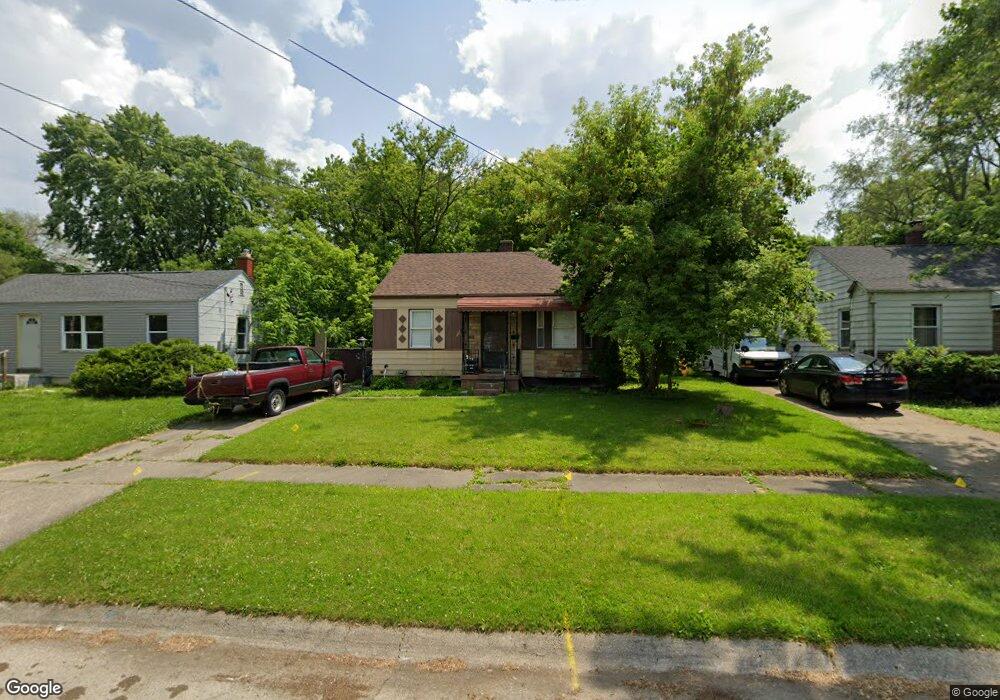
933 Barney Ave Flint, MI 48503
Mannhall Park NeighborhoodEstimated Value: $47,000 - $50,411
2
Beds
1
Bath
733
Sq Ft
$66/Sq Ft
Est. Value
About This Home
This home is located at 933 Barney Ave, Flint, MI 48503 and is currently estimated at $48,353, approximately $65 per square foot. 933 Barney Ave is a home located in Genesee County with nearby schools including Durant-Tuuri-Mott Elementary School, St. Paul Lutheran School, and First Flint Seventh-day Adventist Christian School.
Ownership History
Date
Name
Owned For
Owner Type
Purchase Details
Closed on
Sep 1, 2011
Sold by
Blandford Betty S
Bought by
Vanlinden Ronald E
Current Estimated Value
Home Financials for this Owner
Home Financials are based on the most recent Mortgage that was taken out on this home.
Original Mortgage
$3,900
Interest Rate
8%
Mortgage Type
Seller Take Back
Purchase Details
Closed on
Sep 20, 2001
Sold by
Bradley Caroline E and Bradley Lon V
Bought by
Blandford Betty S
Create a Home Valuation Report for This Property
The Home Valuation Report is an in-depth analysis detailing your home's value as well as a comparison with similar homes in the area
Home Values in the Area
Average Home Value in this Area
Purchase History
| Date | Buyer | Sale Price | Title Company |
|---|---|---|---|
| Vanlinden Ronald E | $4,000 | Attorney | |
| Vanlinden Ronald E | $4,000 | None Available | |
| Blandford Betty S | $55,000 | Sargents Title Company |
Source: Public Records
Mortgage History
| Date | Status | Borrower | Loan Amount |
|---|---|---|---|
| Previous Owner | Vanlinden Ronald E | $3,900 |
Source: Public Records
Tax History
| Year | Tax Paid | Tax Assessment Tax Assessment Total Assessment is a certain percentage of the fair market value that is determined by local assessors to be the total taxable value of land and additions on the property. | Land | Improvement |
|---|---|---|---|---|
| 2025 | $936 | $21,100 | $0 | $0 |
| 2024 | $849 | $21,500 | $0 | $0 |
| 2023 | $835 | $18,800 | $0 | $0 |
| 2022 | $0 | $15,300 | $0 | $0 |
| 2021 | $867 | $13,100 | $0 | $0 |
| 2020 | $784 | $11,700 | $0 | $0 |
| 2019 | $1,173 | $10,700 | $0 | $0 |
| 2018 | $774 | $10,700 | $0 | $0 |
| 2017 | $753 | $0 | $0 | $0 |
| 2016 | $748 | $0 | $0 | $0 |
| 2015 | -- | $0 | $0 | $0 |
| 2014 | -- | $0 | $0 | $0 |
| 2012 | -- | $14,100 | $0 | $0 |
Source: Public Records
Map
Nearby Homes
- 916 Mann Ave
- 960 Mann Ave
- 976 Barney Ave
- 3302 Van Buren Ave
- 911 Hughes Ave
- 945 Salisbury Ave
- 1017 Stocker Ave
- 960 Salisbury Ave
- 3517 Norwood Dr
- 932 Bradley Ave
- 2710 Mansfield Ave
- 1122 Stocker Ave
- 2663 W Court St
- 3405 Sherwood Dr
- 1202 Knapp Ave
- 0000 Beecher Rd
- 863 Tacken St
- 3413 Augusta St
- 2805 Reynolds St
- 874 Tacken St
Your Personal Tour Guide
Ask me questions while you tour the home.