Estimated Value: $476,000 - $565,000
4
Beds
4
Baths
3,119
Sq Ft
$167/Sq Ft
Est. Value
About This Home
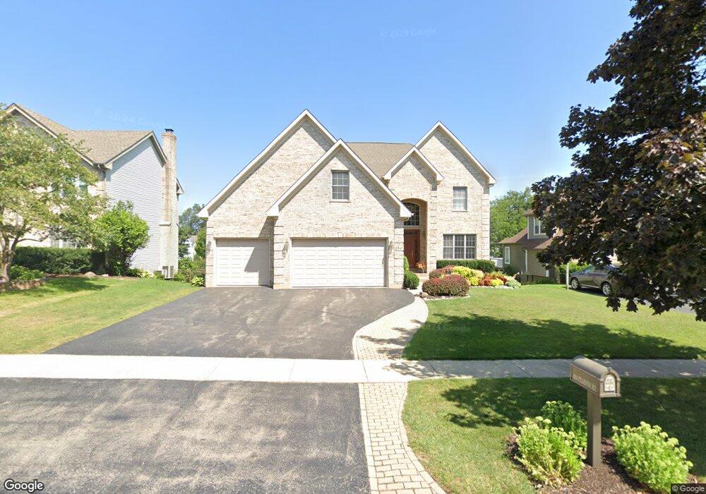
This home is located at 934 Pearson Rd, Cary, IL 60013 and is currently estimated at $521,603, approximately $167 per square foot. 934 Pearson Rd is a home located in McHenry County with nearby schools including Briargate Elementary School, Cary Jr High School, and Cary-Grove High School.
Ownership History
Date
Name
Owned For
Owner Type
Purchase Details
Closed on
Mar 26, 2018
Sold by
Turksey Brett and Turksey Dana M
Bought by
Jania Ronald M and Jania Sara L
Current Estimated Value
Home Financials for this Owner
Home Financials are based on the most recent Mortgage that was taken out on this home.
Original Mortgage
$150,001
Outstanding Balance
$88,059
Interest Rate
4.4%
Mortgage Type
New Conventional
Estimated Equity
$433,544
Purchase Details
Closed on
Jun 22, 2011
Sold by
Turskey Brett and Turskey Dana M
Bought by
Turskey Brett and Turskey Dana M
Purchase Details
Closed on
Feb 21, 2003
Sold by
Andre Brant J and Andre Donna
Bought by
Turskey Brett and Turskey Dana
Purchase Details
Closed on
Mar 18, 1996
Sold by
American National Bk & Tr Co Of Chicago
Bought by
Andre Brant J
Purchase Details
Closed on
Mar 31, 1995
Sold by
Cragin Service Corp
Bought by
Calia Development Inc and Unverricht Sue Ann
Create a Home Valuation Report for This Property
The Home Valuation Report is an in-depth analysis detailing your home's value as well as a comparison with similar homes in the area
Home Values in the Area
Average Home Value in this Area
Purchase History
| Date | Buyer | Sale Price | Title Company |
|---|---|---|---|
| Jania Ronald M | $378,000 | Attorney | |
| Turskey Brett | -- | None Available | |
| Turskey Brett | $72,000 | -- | |
| Andre Brant J | $57,000 | -- | |
| Calia Development Inc | $42,500 | Chicago Title |
Source: Public Records
Mortgage History
| Date | Status | Borrower | Loan Amount |
|---|---|---|---|
| Open | Jania Ronald M | $150,001 |
Source: Public Records
Tax History Compared to Growth
Tax History
| Year | Tax Paid | Tax Assessment Tax Assessment Total Assessment is a certain percentage of the fair market value that is determined by local assessors to be the total taxable value of land and additions on the property. | Land | Improvement |
|---|---|---|---|---|
| 2024 | $13,699 | $178,672 | $11,575 | $167,097 |
| 2023 | $13,311 | $159,799 | $10,352 | $149,447 |
| 2022 | $12,318 | $142,553 | $9,343 | $133,210 |
| 2021 | $11,720 | $132,805 | $8,704 | $124,101 |
| 2020 | $11,362 | $128,104 | $8,396 | $119,708 |
| 2019 | $11,125 | $122,611 | $8,036 | $114,575 |
| 2018 | $11,068 | $114,172 | $18,446 | $95,726 |
| 2017 | $10,869 | $107,557 | $17,377 | $90,180 |
| 2016 | $10,803 | $100,879 | $16,298 | $84,581 |
| 2013 | -- | $77,492 | $15,204 | $62,288 |
Source: Public Records
Map
Nearby Homes
- 204 Country Commons Rd
- 515 Surrey Ridge Dr
- 1016 S Fox Trails Dr
- 550 Enclave Dr
- 30 S Wulff St
- 386 Copper Canyon Trail
- 964 Woodbridge Dr
- 226 Aberdeen Rd
- 888 Blazing Star Trail
- 715 Fox Trail Terrace
- 1436 New Haven Dr
- 550 Norman Dr
- 0 Kaper Dr
- 1387 New Haven Dr
- 442 New Haven Dr
- 548 New Haven Dr
- 60 S Seebert St
- 3712 3 Oaks Rd
- 461 W Oriole Trail
- Lots 2,3,4 Northwest Hwy
- 922 Pearson Rd
- 940 Pearson Rd
- 931 Milford St
- 937 Milford St
- 910 Pearson Rd
- 948 Pearson Rd
- 925 Milford St
- 943 Milford St
- 919 Milford St
- 927 Pearson Rd
- 937 Pearson Rd
- 919 Pearson Rd
- 952 Pearson Rd
- 900 Pearson Rd
- 943 Pearson Rd
- 913 Milford St
- 909 Pearson Rd
- 949 Pearson Rd
- 960 Pearson Rd
- 956 Verona Dr Unit 2387