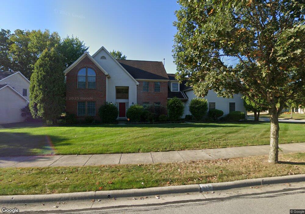
935 Wake Dr Westerville, OH 43082
Estimated Value: $655,338 - $776,000
4
Beds
4
Baths
3,740
Sq Ft
$186/Sq Ft
Est. Value
About This Home
This home is located at 935 Wake Dr, Westerville, OH 43082 and is currently estimated at $694,585, approximately $185 per square foot. 935 Wake Dr is a home located in Delaware County with nearby schools including Robert Frost Elementary School, Heritage Middle School, and Westerville-North High School.
Ownership History
Date
Name
Owned For
Owner Type
Purchase Details
Closed on
Jan 7, 1999
Sold by
Capoccia Builde Cugini and Capoccia Builde
Bought by
Bundu Abu B and Bundu Hawa
Current Estimated Value
Home Financials for this Owner
Home Financials are based on the most recent Mortgage that was taken out on this home.
Original Mortgage
$250,000
Interest Rate
6.83%
Mortgage Type
New Conventional
Create a Home Valuation Report for This Property
The Home Valuation Report is an in-depth analysis detailing your home's value as well as a comparison with similar homes in the area
Home Values in the Area
Average Home Value in this Area
Purchase History
| Date | Buyer | Sale Price | Title Company |
|---|---|---|---|
| Bundu Abu B | $338,449 | -- |
Source: Public Records
Mortgage History
| Date | Status | Borrower | Loan Amount |
|---|---|---|---|
| Previous Owner | Bundu Abu B | $250,000 |
Source: Public Records
Tax History
| Year | Tax Paid | Tax Assessment Tax Assessment Total Assessment is a certain percentage of the fair market value that is determined by local assessors to be the total taxable value of land and additions on the property. | Land | Improvement |
|---|---|---|---|---|
| 2024 | $9,656 | $189,530 | $37,660 | $151,870 |
| 2023 | $9,546 | $189,530 | $37,660 | $151,870 |
| 2022 | $9,647 | $148,190 | $31,710 | $116,480 |
| 2021 | $9,730 | $148,190 | $31,710 | $116,480 |
| 2020 | $9,794 | $148,190 | $31,710 | $116,480 |
| 2019 | $9,234 | $133,460 | $27,580 | $105,880 |
| 2018 | $9,078 | $133,460 | $27,580 | $105,880 |
| 2017 | $9,044 | $127,930 | $25,730 | $102,200 |
| 2016 | $9,494 | $127,930 | $25,730 | $102,200 |
| 2015 | $9,081 | $127,930 | $25,730 | $102,200 |
| 2014 | $9,172 | $127,930 | $25,730 | $102,200 |
| 2013 | $9,176 | $127,930 | $25,730 | $102,200 |
Source: Public Records
Map
Nearby Homes
- 6945 Tussic Street Rd
- 7568 Park Bend Ct
- 1161 Tidewater Ct
- 787 Centerpark Dr
- 1103 Blue Heron Dr
- 8133 Dunaway Ln
- 8191 Maxtown Rd
- 6685 Tussic Street Rd
- 6798 Garden View Dr
- 7026 Sunbury Rd
- 390 Ashford Dr
- 490 Blue Heron Ct
- 1216 Hooverview Dr
- 8118 Saybrook Dr
- 7524 Center Green Dr
- 660 Albion Place Unit 8660
- 262 Crawford Ct
- 478 Burns Dr N
- 6663 Hilmar Dr
- 6471 Margaret Dr
Your Personal Tour Guide
Ask me questions while you tour the home.