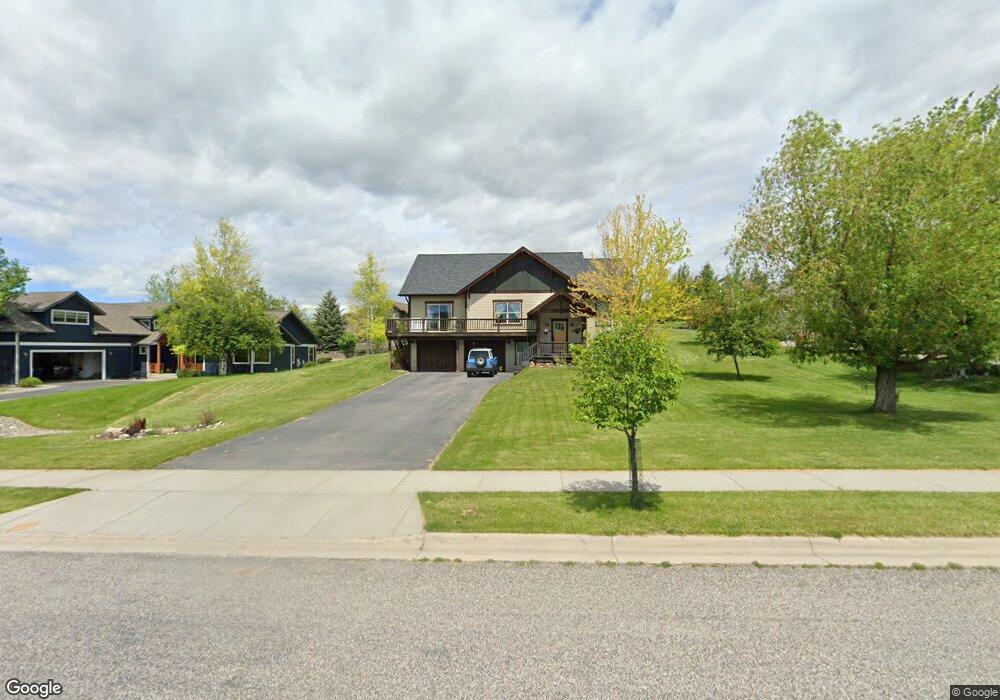
938 St Andrews Dr Bozeman, MT 59715
North Bozeman NeighborhoodEstimated Value: $868,000 - $1,373,000
4
Beds
3
Baths
2,875
Sq Ft
$361/Sq Ft
Est. Value
About This Home
This home is located at 938 St Andrews Dr, Bozeman, MT 59715 and is currently estimated at $1,037,876, approximately $361 per square foot. 938 St Andrews Dr is a home located in Gallatin County with nearby schools including Hawthorne Elementary School, Chief Joseph Middle School, and Gallatin High School.
Ownership History
Date
Name
Owned For
Owner Type
Purchase Details
Closed on
Dec 23, 2005
Sold by
Jmb Inc
Bought by
Daenen Charles L and Daenen Mikel J
Current Estimated Value
Home Financials for this Owner
Home Financials are based on the most recent Mortgage that was taken out on this home.
Original Mortgage
$295,000
Outstanding Balance
$165,838
Interest Rate
6.37%
Mortgage Type
Fannie Mae Freddie Mac
Estimated Equity
$872,038
Create a Home Valuation Report for This Property
The Home Valuation Report is an in-depth analysis detailing your home's value as well as a comparison with similar homes in the area
Home Values in the Area
Average Home Value in this Area
Purchase History
| Date | Buyer | Sale Price | Title Company |
|---|---|---|---|
| Daenen Charles L | -- | Security Title Company |
Source: Public Records
Mortgage History
| Date | Status | Borrower | Loan Amount |
|---|---|---|---|
| Open | Daenen Charles L | $295,000 |
Source: Public Records
Tax History Compared to Growth
Tax History
| Year | Tax Paid | Tax Assessment Tax Assessment Total Assessment is a certain percentage of the fair market value that is determined by local assessors to be the total taxable value of land and additions on the property. | Land | Improvement |
|---|---|---|---|---|
| 2025 | $4,348 | $901,300 | $0 | $0 |
| 2024 | $5,384 | $808,800 | $0 | $0 |
| 2023 | $5,208 | $808,800 | $0 | $0 |
| 2022 | $4,013 | $523,400 | $0 | $0 |
| 2021 | $4,429 | $523,400 | $0 | $0 |
| 2020 | $3,428 | $401,200 | $0 | $0 |
| 2019 | $3,506 | $401,200 | $0 | $0 |
| 2018 | $2,895 | $306,880 | $0 | $0 |
| 2017 | $2,861 | $306,880 | $0 | $0 |
| 2016 | $1,922 | $203,400 | $0 | $0 |
| 2015 | $3,842 | $406,800 | $0 | $0 |
| 2014 | $4,081 | $254,400 | $0 | $0 |
Source: Public Records
Map
Nearby Homes
- 523 St Andrews Dr
- 3213 Augusta Dr
- 1055 Caddie Ct
- 1031 Boylan Rd
- 1050 Boylan Rd Unit 4
- 2503 Valhalla Ct
- 2403 Birdie Dr Unit A
- TBD Lucy Ln
- TBD Canyon Gate Blvd
- TBD Blvd
- 2402 Blue Silos Way
- 323 Gallatin Park Dr Unit 102/202
- TBD Story Mill Rd
- 27737 Frontage Rd
- TBD Cultivar St
- 2434 Richau Ln
- 611 Nikles Dr Unit 102/202
- 902 St Andrews Dr
- 972 St Andrews Dr
- 645 Saint Andrews Dr
- Lot 33 Saint Andrews Dr
- Lot 32 Saint Andrews Dr
- 556 Saint Andrews Dr
- L14 Saint Andrews Dr
- Lot 2 Bridger Creek Sub
- 610 St Andrews Dr
- 886 St Andrews Dr
- 939 St Andrews Dr
- 644 St Andrews Dr
- TBD St Andrews Dr
- 903 St Andrews Dr
- 578 St Andrews Dr
- 973 St Andrews Dr
- 668 St Andrews
- 887 St Andrews Dr
- 556 St Andrews Dr
- 696 Saint Andrews Dr