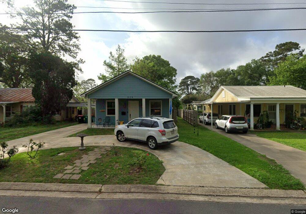
939 Azalea St Lafayette, LA 70506
Saints Streets NeighborhoodEstimated Value: $205,000 - $232,000
--
Bed
--
Bath
1,338
Sq Ft
$162/Sq Ft
Est. Value
About This Home
This home is located at 939 Azalea St, Lafayette, LA 70506 and is currently estimated at $217,304, approximately $162 per square foot. 939 Azalea St is a home located in Lafayette Parish with nearby schools including Woodvale Elementary School, Lafayette Middle School, and Haverhill High School.
Ownership History
Date
Name
Owned For
Owner Type
Purchase Details
Closed on
Jul 31, 2017
Sold by
Burgard Neil and Weifenbach Dona
Bought by
Radcliff Gregory David and Radcliff Peggy Nan Katherine
Current Estimated Value
Home Financials for this Owner
Home Financials are based on the most recent Mortgage that was taken out on this home.
Original Mortgage
$40,000
Outstanding Balance
$33,305
Interest Rate
3.88%
Mortgage Type
Purchase Money Mortgage
Estimated Equity
$183,999
Purchase Details
Closed on
Oct 13, 2008
Sold by
Bussy Beatrice and Bussy Mary Joyce
Bought by
Blanchard Rachelle Marie
Create a Home Valuation Report for This Property
The Home Valuation Report is an in-depth analysis detailing your home's value as well as a comparison with similar homes in the area
Home Values in the Area
Average Home Value in this Area
Purchase History
| Date | Buyer | Sale Price | Title Company |
|---|---|---|---|
| Radcliff Gregory David | $50,000 | None Available | |
| Blanchard Rachelle Marie | $30,000 | None Available |
Source: Public Records
Mortgage History
| Date | Status | Borrower | Loan Amount |
|---|---|---|---|
| Open | Radcliff Gregory David | $40,000 |
Source: Public Records
Tax History Compared to Growth
Tax History
| Year | Tax Paid | Tax Assessment Tax Assessment Total Assessment is a certain percentage of the fair market value that is determined by local assessors to be the total taxable value of land and additions on the property. | Land | Improvement |
|---|---|---|---|---|
| 2024 | $1,323 | $18,755 | $2,689 | $16,066 |
| 2023 | $1,323 | $18,755 | $2,689 | $16,066 |
| 2022 | $1,961 | $18,745 | $2,689 | $16,056 |
| 2021 | $1,968 | $18,745 | $2,689 | $16,056 |
| 2020 | $1,961 | $18,745 | $2,689 | $16,056 |
| 2019 | $927 | $18,745 | $2,689 | $16,056 |
| 2018 | $274 | $2,689 | $2,689 | $0 |
| 2017 | $114 | $1,120 | $1,120 | $0 |
| 2015 | $114 | $1,120 | $1,120 | $0 |
| 2013 | -- | $1,120 | $1,120 | $0 |
Source: Public Records
Map
Nearby Homes
- 605 Saint Frances St
- 707 Saint Patrick St
- 527 Saint Joseph St
- 234 Brookside Dr
- 610 Saint Joseph St
- 713 Saint Louis St
- 920 Saint Patrick St
- 809 Saint Thomas St
- 761 Saint Louis St
- 768 Saint Louis St
- 104 Whittington Dr Unit M
- 2505 Johnston St
- 120 Oak Crest Dr
- 720 Myrtle Place
- 128 Oakview Blvd
- 219 Brashear St
- 111 Hamilton Place
- 130 Twin Oaks Blvd
- 135 Clark Ct
- 1104 Saint John St