
Seller's Agent in 2025
Shaughnessy Dusling
Real Broker NY LLC
(631) 612-1616
4 in this area
158 Total Sales
Estimated Value: $534,000 - $559,000
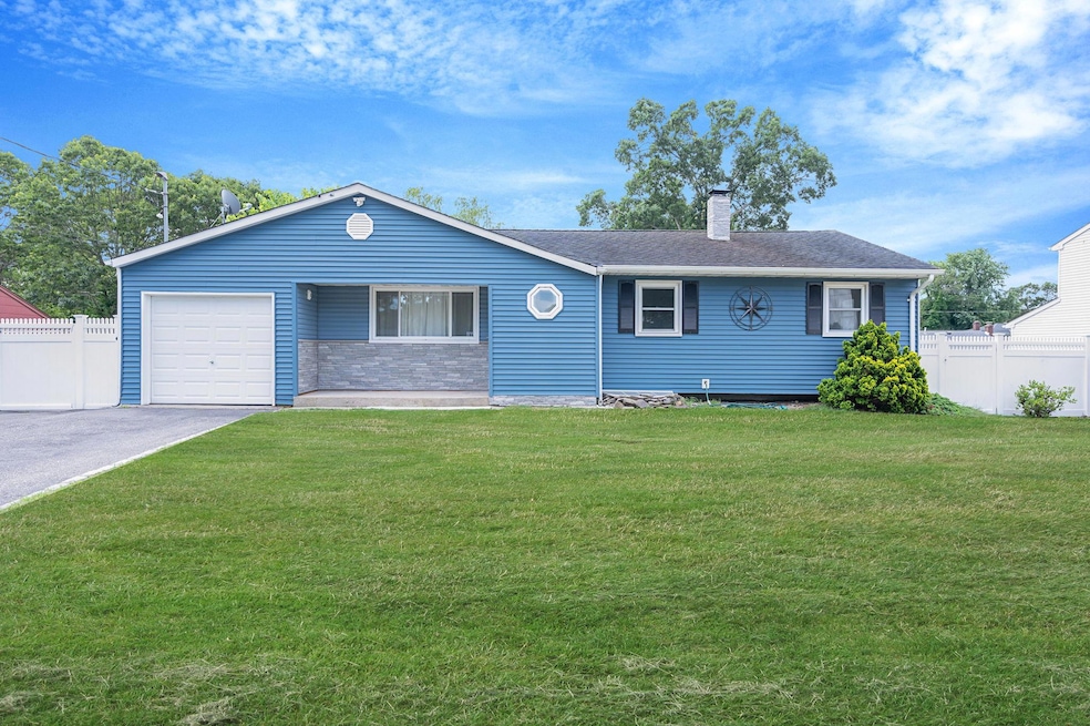
This lovely ranch has three bedrooms and 2.5 bathrooms that are move in ready! Screened-in sunroom can extend that Summer feeling well into the Fall and Winter because it is both heated and cooled. Featuring a large backyard and a full finished basement with outside separate entry AND egress window, there’s so much potential here for house hackers and extended house guests alike! 1 car attached garage. Oil Burner from 2017, Roof from 2008 and Solar from 2023, you can feel relief that things are in great shape and easy to maintain. Minutes to shopping, schools and beach!
Last Agent to Sell the Property
Real Broker NY LLC Brokerage Phone: 518-730-4228 License #10301220430 Listed on: 07/20/2025
We collect this data history from publicly available records. To have your information removed, we recommend requesting removal directly through your county’s website.
We collect this data history from publicly available records. To have your information removed, we recommend requesting removal directly through your county’s website.
| Date | Buyer | Sale Price | Title Company |
|---|---|---|---|
| $550,000 | -- | ||
| -- | -- | ||
| -- | -- | ||
| -- | Commonwealth Land Title Ins |
We collect this data history from publicly available records. To have your information removed, we recommend requesting removal directly through your county’s website.
| Date | Status | Borrower | Loan Amount |
|---|---|---|---|
| Previous Owner | $540,038 | ||
| Previous Owner | $144,850 |
We collect this data history from publicly available records. To have your information removed, we recommend requesting removal directly through your county’s website.
| Date | Event | Price | List to Sale | Price per Sq Ft |
|---|---|---|---|---|
| 11/13/2025 11/13/25 | Sold | $550,000 | +10.0% | $277 / Sq Ft |
| 08/09/2025 08/09/25 | Pending | -- | -- | -- |
| 07/20/2025 07/20/25 | For Sale | $499,999 | -- | $252 / Sq Ft |
We collect this data history from publicly available records. To have your information removed, we recommend requesting removal directly through your county’s website.
| Year | Tax Paid | Tax Assessment Tax Assessment Total Assessment is a certain percentage of the fair market value that is determined by local assessors to be the total taxable value of land and additions on the property. | Land | Improvement |
|---|---|---|---|---|
| 2025 | $8,328 | $2,020 | $150 | $1,870 |
| 2024 | $8,328 | $2,020 | $150 | $1,870 |
| 2023 | $8,328 | $2,020 | $150 | $1,870 |
| 2022 | $9,624 | $2,020 | $150 | $1,870 |
| 2021 | $9,624 | $2,020 | $150 | $1,870 |
| 2020 | $10,117 | $2,020 | $150 | $1,870 |
| 2019 | $10,117 | $0 | $0 | $0 |
| 2018 | $9,360 | $2,130 | $150 | $1,980 |
| 2017 | $9,360 | $2,130 | $150 | $1,980 |
| 2016 | $9,316 | $2,130 | $150 | $1,980 |
| 2015 | -- | $2,130 | $150 | $1,980 |
| 2014 | -- | $2,130 | $150 | $1,980 |
Seller's Agent in 2025
Shaughnessy Dusling
Real Broker NY LLC
(631) 612-1616
4 in this area
158 Total Sales
Seller Co-Listing Agent in 2025
Cynthia McKenna
Real Broker NY LLC
(631) 278-6987
4 in this area
179 Total Sales
M
Buyer's Agent in 2025
Misshel Beck
Real Broker NY LLC
5 in this area
47 Total Sales
Buyer Co-Listing Agent in 2025
Wendy Rodriguez
Real Broker NY LLC
(631) 398-1803
8 in this area
156 Total Sales
Source: OneKey® MLS
MLS Number: 891489
APN: 0200-978-80-04-00-046-000
Disclaimer: Certain information contained herein is derived from information provided by parties other than Homes.com. All information provided is deemed reliable, but is not guaranteed to be accurate and should be independently verified.
![]() The data relating to real estate for sale or lease on this web site comes in part from OneKey® MLS. Real estate listings held by brokerage firms other than Ten-X are marked with the OneKey® MLS logo or an abbreviated logo and detailed information about them includes the name of the listing broker.
The data relating to real estate for sale or lease on this web site comes in part from OneKey® MLS. Real estate listings held by brokerage firms other than Ten-X are marked with the OneKey® MLS logo or an abbreviated logo and detailed information about them includes the name of the listing broker.
Based on information submitted to the MLS GRID. All data is obtained from various sources and may not have been verified by broker or MLS GRID. Supplied Open House Information is subject to change without notice. All information should be independently reviewed and verified for accuracy. Properties may or may not be listed by the office/agent presenting the information. Some IDX listings have been excluded from this website. IDX information is provided exclusively for personal, non-commercial use, and may not be used for any purpose other than to identify prospective properties consumers may be interested in purchasing.
Information is deemed reliable but not guaranteed.
Copyright 2026 OneKey® MLS. All rights reserved.
Based on information submitted to the MLS GRID
Listings courtesy of OneKey® MLS as distributed by MLS GRID
Ask me questions while you tour the home.