Estimated Value: $351,000 - $397,000
3
Beds
1
Bath
1,008
Sq Ft
$367/Sq Ft
Est. Value
About This Home
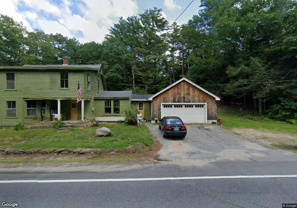
This home is located at 94 Center Rd, Weare, NH 03281 and is currently estimated at $369,922, approximately $366 per square foot. 94 Center Rd is a home located in Hillsborough County with nearby schools including Center Woods Elementary School, Weare Middle School, and John Stark Regional High School.
Ownership History
Date
Name
Owned For
Owner Type
Purchase Details
Closed on
Jun 29, 2009
Sold by
Us Bank Na Tr
Bought by
Palmer Dawn M
Current Estimated Value
Home Financials for this Owner
Home Financials are based on the most recent Mortgage that was taken out on this home.
Original Mortgage
$140,313
Interest Rate
4.92%
Mortgage Type
Purchase Money Mortgage
Purchase Details
Closed on
Sep 23, 2008
Sold by
Morrison Paul D
Bought by
Us Bank Na
Purchase Details
Closed on
Sep 23, 1998
Sold by
Montgomery Joseph F and Montgomery Bernice C
Bought by
Morrison Paul D and Morrison Tina A
Home Financials for this Owner
Home Financials are based on the most recent Mortgage that was taken out on this home.
Original Mortgage
$112,098
Interest Rate
6.87%
Mortgage Type
Purchase Money Mortgage
Create a Home Valuation Report for This Property
The Home Valuation Report is an in-depth analysis detailing your home's value as well as a comparison with similar homes in the area
Home Values in the Area
Average Home Value in this Area
Purchase History
| Date | Buyer | Sale Price | Title Company |
|---|---|---|---|
| Palmer Dawn M | $143,000 | -- | |
| Us Bank Na | $149,700 | -- | |
| Morrison Paul D | $109,900 | -- |
Source: Public Records
Mortgage History
| Date | Status | Borrower | Loan Amount |
|---|---|---|---|
| Open | Morrison Paul D | $135,257 | |
| Closed | Morrison Paul D | $140,313 | |
| Previous Owner | Morrison Paul D | $112,098 |
Source: Public Records
Tax History Compared to Growth
Tax History
| Year | Tax Paid | Tax Assessment Tax Assessment Total Assessment is a certain percentage of the fair market value that is determined by local assessors to be the total taxable value of land and additions on the property. | Land | Improvement |
|---|---|---|---|---|
| 2024 | $5,057 | $248,000 | $111,000 | $137,000 |
| 2023 | $4,623 | $245,400 | $111,000 | $134,400 |
| 2022 | $4,270 | $245,400 | $111,000 | $134,400 |
| 2021 | $4,221 | $245,400 | $111,000 | $134,400 |
| 2020 | $4,275 | $178,500 | $77,800 | $100,700 |
| 2019 | $4,232 | $178,500 | $77,800 | $100,700 |
| 2018 | $4,104 | $178,200 | $77,800 | $100,400 |
| 2016 | $4,033 | $180,300 | $79,900 | $100,400 |
| 2015 | $3,933 | $175,500 | $77,700 | $97,800 |
| 2014 | $3,898 | $175,500 | $77,700 | $97,800 |
| 2013 | $3,817 | $175,500 | $77,700 | $97,800 |
Source: Public Records
Map
Nearby Homes
- 92 Woodbury Rd
- 10 Sap House Rd
- 281 Hodgdon Rd
- 30 Dels Way
- 62 Collins Landing Rd Unit 46
- 732 Concord Stage Rd Unit 5
- 194 Buckley Rd Unit 2
- 194 Buckley Rd Unit 44
- 107 Branch Rd
- 0 Huntington Hill Rd Unit 69
- 0 Als Dr Unit 196
- 57 Lyndsey Ln
- 463 Craney Hill Rd
- 849 River Rd
- 11 White Birch Rd
- 586 C-4 Craney Hill Rd
- 196 Deering Center Rd
- 624 S Stark Hwy
- 40 N Woods Rd
- 200 Mountain Rd
- 102 Center Rd
- 108 Center Rd
- 92 Center Rd
- 99 Center Rd
- 130 Center Rd
- 127 Center Rd
- 40 Center Brook Ln
- 135 Center Rd
- 139 Center Rd
- 50 Center Brook Ln Unit 2
- 50 Center Brook Ln
- 50 Center Brook Ln Unit A
- 50B Center Brook Ln Unit 2
- 50B Center Brook Ln Unit B
- 50 Center Brook Ln Unit B
- 28 Center Brook Ln
- 56 Woodbury Rd
- 146 Center Rd
- 149 Center Rd
- 18 Center Brook Ln