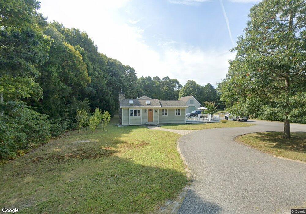
94 Red Brook Rd Mashpee, MA 02649
Estimated Value: $651,000 - $820,000
3
Beds
2
Baths
1,573
Sq Ft
$458/Sq Ft
Est. Value
About This Home
This home is located at 94 Red Brook Rd, Mashpee, MA 02649 and is currently estimated at $719,931, approximately $457 per square foot. 94 Red Brook Rd is a home located in Barnstable County with nearby schools including Kenneth C. Coombs School, Quashnet School, and Mashpee Middle School.
Ownership History
Date
Name
Owned For
Owner Type
Purchase Details
Closed on
Nov 25, 1997
Sold by
Redbrook Rd Rt and Esper James J
Bought by
Sliwa Michael
Current Estimated Value
Purchase Details
Closed on
Aug 20, 1997
Sold by
Redbrook Rd Rt and Esper James J
Bought by
Sliwa Michael
Home Financials for this Owner
Home Financials are based on the most recent Mortgage that was taken out on this home.
Original Mortgage
$40,000
Interest Rate
7.42%
Mortgage Type
Purchase Money Mortgage
Create a Home Valuation Report for This Property
The Home Valuation Report is an in-depth analysis detailing your home's value as well as a comparison with similar homes in the area
Purchase History
We collect this data history from publicly available records. To have your information removed, we recommend requesting removal directly through your county’s website.
| Date | Buyer | Sale Price | Title Company |
|---|---|---|---|
| Sliwa Michael | $40,000 | -- | |
| Sliwa Michael | $40,000 | -- |
Source: Public Records
Mortgage History
We collect this data history from publicly available records. To have your information removed, we recommend requesting removal directly through your county’s website.
| Date | Status | Borrower | Loan Amount |
|---|---|---|---|
| Open | Sliwa Michael | $135,000 | |
| Previous Owner | Sliwa Michael | $40,000 |
Source: Public Records
Tax History
| Year | Tax Paid | Tax Assessment Tax Assessment Total Assessment is a certain percentage of the fair market value that is determined by local assessors to be the total taxable value of land and additions on the property. | Land | Improvement |
|---|---|---|---|---|
| 2025 | $3,609 | $545,200 | $200,100 | $345,100 |
| 2024 | $3,311 | $514,900 | $181,900 | $333,000 |
| 2023 | $3,151 | $449,500 | $173,200 | $276,300 |
| 2022 | $3,035 | $371,500 | $140,800 | $230,700 |
| 2021 | $2,924 | $322,400 | $126,800 | $195,600 |
| 2020 | $2,844 | $312,900 | $122,000 | $190,900 |
| 2019 | $2,735 | $302,200 | $122,000 | $180,200 |
| 2018 | $8,355 | $285,300 | $122,000 | $163,300 |
| 2017 | $2,497 | $271,700 | $122,000 | $149,700 |
| 2016 | $2,434 | $263,400 | $122,000 | $141,400 |
| 2015 | $2,351 | $258,100 | $122,000 | $136,100 |
| 2014 | $2,419 | $257,600 | $120,500 | $137,100 |
Source: Public Records
Map
Nearby Homes
- 7 Osprey Ct
- 8 Osprey Ct
- 4 Osprey Ct
- 26 Cobblestone Cir
- 24 Cobblestone Cir
- 14 Azalea Ln
- 69 Cobblestone Cir
- 79 Cobblestone Cir
- 120 Degrass Rd
- 89 Degrass Rd
- 10 Rock Landing Rd
- 26 The Morgan Cir
- 55 Summersea Rd
- 100 The Paddock Cir
- 20 Saltwater Cir
- 80 & 86 Summersea Rd
- 80 Summersea Rd
- 86 Summersea Rd
- 102 Summersea Rd
- 140 Summersea Rd
- 100 Red Brook Rd
- 85 Red Brook Rd
- 74 Red Brook Rd
- 79 Red Brook Rd
- 86 Red Brook Rd
- 81 Red Brook Rd
- 83 Red Brook Rd
- 80 Red Brook Rd
- 108 Red Brook Rd
- 108 Redbrook
- 122 Red Brook Rd
- 122 Red Brook Rd
- 4 Brians Ln
- 66 Red Brook Rd
- 58 Red Brook Rd
- 47 Great Oak Rd
- 65 Red Brook Rd
- 126 Red Brook Rd
- 50 Sipps Rd
- 7 Brians Ln
Your Personal Tour Guide
Ask me questions while you tour the home.