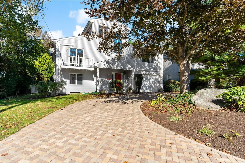
94 Spindrift St Jamestown, RI 02835
Jamestown Shores NeighborhoodEstimated payment $5,603/month
Highlights
- Marina
- Water Views
- Deck
- Melrose Avenue School Rated A-
- Media Room
- Contemporary Architecture
About This Home
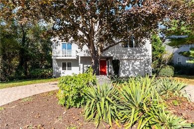
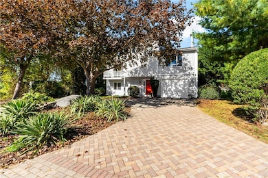
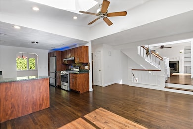
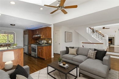
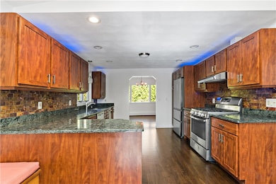
Welcome to 94 Spindrift Street a Jamestown opportunity just one block from the water with endless potential including an in-law This three-level home offers 2 bedrooms (with a 3 bedroom septic system) and 3.5 baths- a flexible layout that can easily convert back to a legal third bedroom by restoring the dining room. Recent upgrades include a brand-new $20,000 roof, new furnace, and new oil tank all setting the stage for a worry-free ownership experience. The main level features multiple living areas, a wood-burning fireplace, and seamless access to private outdoor spaces, including a side deck and a private backyard with stone patios and mature landscaping ideal for entertaining or quiet relaxation. Upstairs, a third-level living area with a gas fireplace opens to a stunning roof deck with seasonal water views, adding a touch of coastal charm and versatility. With potential for an in-law or guest suite and multiple layout possibilities, this property caters to a wide range of lifestyles and creative visions. Situated just moments from local beaches and Jamestown's charming village, 94 Spindrift offers the perfect blend of privacy, convenience, and opportunity ideal for investors, developers, or anyone looking to create their forever coastal retreat.
Home Details
Home Type
- Single Family
Est. Annual Taxes
- $4,304
Year Built
- Built in 1988
Lot Details
- 7,405 Sq Ft Lot
- Sprinkler System
- Property is zoned R40
Parking
- 1 Car Attached Garage
- Driveway
Home Design
- Contemporary Architecture
- Slab Foundation
- Vinyl Siding
Interior Spaces
- 2,589 Sq Ft Home
- 3-Story Property
- Wet Bar
- 2 Fireplaces
- Fireplace Features Masonry
- Media Room
- Game Room
- Storage Room
- Home Gym
- Water Views
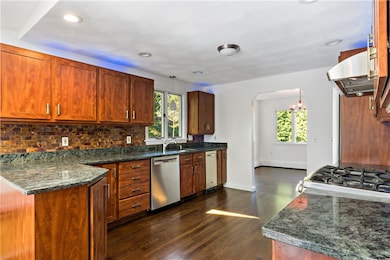
Kitchen
- Oven
- Range
- Dishwasher
- Trash Compactor
Flooring
- Wood
- Carpet
- Ceramic Tile
Bedrooms and Bathrooms
- 2 Bedrooms
Laundry
- Dryer
- Washer
Finished Basement
- Basement Fills Entire Space Under The House
- Interior and Exterior Basement Entry
Outdoor Features
- Walking Distance to Water
- Balcony
- Deck
- Patio
- Porch
Utilities
- Ductless Heating Or Cooling System
- Cooling System Mounted In Outer Wall Opening
- Forced Air Heating System
- Heating System Uses Oil
- Baseboard Heating
- 100 Amp Service
- Private Water Source
- Well
- Oil Water Heater
- Septic Tank
Community Details
- Marina
Listing and Financial Details
- Tax Lot 268
- Assessor Parcel Number 94SPINDRIFTSTJAME
Map
Home Values in the Area
Average Home Value in this Area
Tax History
| Year | Tax Paid | Tax Assessment Tax Assessment Total Assessment is a certain percentage of the fair market value that is determined by local assessors to be the total taxable value of land and additions on the property. | Land | Improvement |
|---|---|---|---|---|
| 2025 | $4,304 | $763,100 | $249,300 | $513,800 |
| 2024 | $3,887 | $542,100 | $188,800 | $353,300 |
| 2023 | $3,856 | $552,500 | $188,800 | $363,700 |
| 2022 | $3,751 | $552,500 | $188,800 | $363,700 |
| 2021 | $4,733 | $571,600 | $147,900 | $423,700 |
| 2020 | $4,613 | $571,600 | $147,900 | $423,700 |
| 2019 | $4,601 | $571,600 | $147,900 | $423,700 |
| 2018 | $4,216 | $476,400 | $132,800 | $343,600 |
| 2017 | $4,126 | $476,400 | $132,800 | $343,600 |
| 2016 | $4,088 | $476,400 | $132,800 | $343,600 |
| 2015 | $3,599 | $409,900 | $141,100 | $268,800 |
| 2014 | $3,587 | $409,900 | $141,100 | $268,800 |
Property History
| Date | Event | Price | List to Sale | Price per Sq Ft |
|---|---|---|---|---|
| 10/17/2025 10/17/25 | For Sale | $995,000 | -- | $384 / Sq Ft |
Purchase History
| Date | Type | Sale Price | Title Company |
|---|---|---|---|
| Deed | $335,000 | -- |
Mortgage History
| Date | Status | Loan Amount | Loan Type |
|---|---|---|---|
| Open | $150,000 | No Value Available | |
| Open | $268,000 | No Value Available |
Source: State-Wide MLS
MLS Number: 1397838
APN: JAME-000005-000000-000268
Disclaimer: Certain information contained herein is derived from information provided by parties other than Homes.com. All information provided is deemed reliable, but is not guaranteed to be accurate and should be independently verified.
![]() IDX information is provided exclusively for personal, non-commercial use, and may not be used for any purpose other than to identify prospective properties consumers may be interested in purchasing. Information is deemed reliable but not guaranteed.
IDX information is provided exclusively for personal, non-commercial use, and may not be used for any purpose other than to identify prospective properties consumers may be interested in purchasing. Information is deemed reliable but not guaranteed.
Copyright © 2025 State-Wide MLS, Inc. All rights reserved.
- 46 Steamboat St
- 1191 N Main Rd
- 9 Union St Unit 2
- 9 Union St Unit 1
- 67 High St
- 104 Howland Ave Unit 2
- 21 Baldwin Ct
- 953 Fort Getty Rd
- 110 Winsor Ave
- 22 Huckleberry Trail
- 28 Newport St
- 15 Treasure Rd
- 43 Maywood Rd
- 8 Woodsia Rd
- 195 Admiral Kalbfus Rd
- 117 Camden Rd
- 46 Bayberry Rd
- 14 Aroostook Trail
- 20 Aroostook Trail
- 31 Bayside Ave Unit 4
