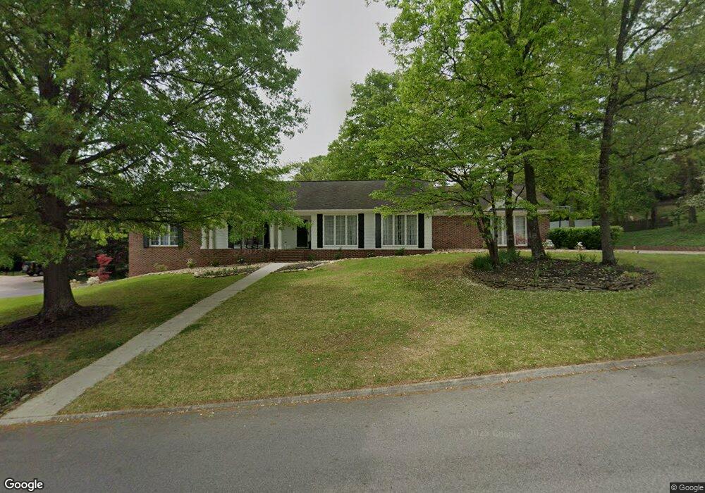
945 Colonial Dr Morristown, TN 37814
Estimated Value: $409,837 - $537,000
--
Bed
3
Baths
2,116
Sq Ft
$225/Sq Ft
Est. Value
About This Home
This home is located at 945 Colonial Dr, Morristown, TN 37814 and is currently estimated at $475,209, approximately $224 per square foot. 945 Colonial Dr is a home located in Hamblen County with nearby schools including Manley Elementary School, West View Middle School, and Morristown West High School.
Ownership History
Date
Name
Owned For
Owner Type
Purchase Details
Closed on
Jan 10, 2011
Sold by
Howard Phyllis L
Bought by
Howard Michael Roy
Current Estimated Value
Purchase Details
Closed on
Oct 2, 1995
Sold by
Pigg George H and Pigg Pamela D
Bought by
Howard Charles
Purchase Details
Closed on
Sep 17, 1991
Bought by
Pigg George H and Pigg Pamela D
Purchase Details
Closed on
Sep 16, 1991
Bought by
Pigg George H and Pigg Pamela D
Purchase Details
Closed on
Sep 1, 1987
Bought by
Word Philip A and Word Patricia B
Purchase Details
Closed on
Apr 22, 1987
Bought by
Mitchell Robert P and Mitchell Ann
Purchase Details
Closed on
Jan 2, 1985
Bought by
Colonial Standard Ventures Inc
Create a Home Valuation Report for This Property
The Home Valuation Report is an in-depth analysis detailing your home's value as well as a comparison with similar homes in the area
Home Values in the Area
Average Home Value in this Area
Purchase History
| Date | Buyer | Sale Price | Title Company |
|---|---|---|---|
| Howard Michael Roy | $260,000 | -- | |
| Howard Charles | $176,500 | -- | |
| Pigg George H | -- | -- | |
| Pigg George H | $151,000 | -- | |
| Word Philip A | $140,100 | -- | |
| Mitchell Robert P | -- | -- | |
| Colonial Standard Ventures Inc | -- | -- |
Source: Public Records
Tax History Compared to Growth
Tax History
| Year | Tax Paid | Tax Assessment Tax Assessment Total Assessment is a certain percentage of the fair market value that is determined by local assessors to be the total taxable value of land and additions on the property. | Land | Improvement |
|---|---|---|---|---|
| 2024 | $1,287 | $73,125 | $10,500 | $62,625 |
| 2023 | $1,287 | $73,125 | $0 | $0 |
| 2022 | $2,311 | $73,125 | $10,500 | $62,625 |
| 2021 | $2,311 | $73,125 | $10,500 | $62,625 |
| 2020 | $2,308 | $73,125 | $10,500 | $62,625 |
| 2019 | $2,275 | $66,900 | $11,625 | $55,275 |
| 2018 | $2,107 | $66,900 | $11,625 | $55,275 |
| 2017 | $2,074 | $66,900 | $11,625 | $55,275 |
| 2016 | $1,980 | $66,900 | $11,625 | $55,275 |
| 2015 | $1,842 | $66,900 | $11,625 | $55,275 |
| 2014 | -- | $66,900 | $11,625 | $55,275 |
| 2013 | -- | $74,450 | $0 | $0 |
Source: Public Records
Map
Nearby Homes
- 2978 Wilshire Blvd
- 1054 Colonial Dr
- 801 Colonial Dr
- 1086 St Ives Ct
- 700 Drinnon Dr
- 3471 Walden Dr
- 3475 Walden Dr
- 400 Drinnon Dr
- 3542 Wedgewood Dr
- 725 Barton Dr
- 3641 Meadowland Dr
- 490 E Sunset Hills
- 2444 Sandstone Dr
- 2454 Sandstone Dr
- 2430 Sandstone Dr
- 2310 Sandstone Dr
- 1736 Jellicorse Rd
- 837 Foxglove Ln
- 2045 N Economy Rd Unit A3
- 3864 Apostle Rd
- 1021 Colonial Dr
- 925 Colonial Dr
- 948 Colonial Dr
- 3116 Providence Cir
- 940 Colonial Dr
- 3109 Providence Cir
- 1035 Colonial Dr
- 1010 St Ives Ct
- 3117 Providence Cir
- 917 Colonial Dr
- 1019 St Ives Ct
- 3124 Providence Cir
- 1051 Colonial Dr
- 924 Colonial Dr
- 3043 Brandywine Cir
- 3007 Wilshire Blvd
- 3035 Brandywine Cir
- 1038 Colonial Dr
- 2995 Wilshire Blvd
- 1024 St Ives Ct