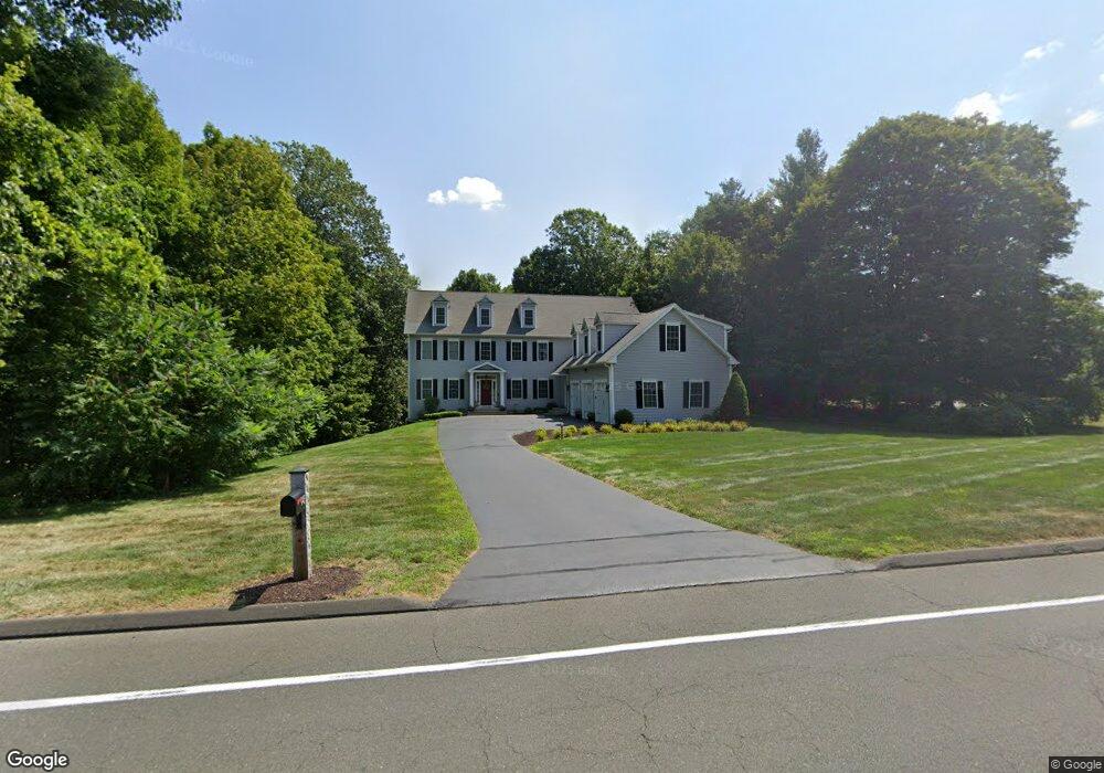
945 New Britain Ave Farmington, CT 06032
Estimated Value: $900,000 - $1,123,964
5
Beds
5
Baths
4,428
Sq Ft
$228/Sq Ft
Est. Value
About This Home
This home is located at 945 New Britain Ave, Farmington, CT 06032 and is currently estimated at $1,009,241, approximately $227 per square foot. 945 New Britain Ave is a home located in Hartford County with nearby schools including West Woods Upper Elementary School, Irving A. Robbins Middle School, and Farmington High School.
Ownership History
Date
Name
Owned For
Owner Type
Purchase Details
Closed on
Jul 31, 2006
Sold by
Mjd Builders Llc
Bought by
Murtari Brian S and Murtari Michele G
Current Estimated Value
Home Financials for this Owner
Home Financials are based on the most recent Mortgage that was taken out on this home.
Original Mortgage
$460,000
Outstanding Balance
$274,824
Interest Rate
6.67%
Estimated Equity
$734,417
Create a Home Valuation Report for This Property
The Home Valuation Report is an in-depth analysis detailing your home's value as well as a comparison with similar homes in the area
Home Values in the Area
Average Home Value in this Area
Purchase History
| Date | Buyer | Sale Price | Title Company |
|---|---|---|---|
| Murtari Brian S | $645,000 | -- |
Source: Public Records
Mortgage History
| Date | Status | Borrower | Loan Amount |
|---|---|---|---|
| Open | Murtari Brian S | $460,000 |
Source: Public Records
Tax History Compared to Growth
Tax History
| Year | Tax Paid | Tax Assessment Tax Assessment Total Assessment is a certain percentage of the fair market value that is determined by local assessors to be the total taxable value of land and additions on the property. | Land | Improvement |
|---|---|---|---|---|
| 2025 | $14,102 | $529,760 | $81,970 | $447,790 |
| 2024 | $13,482 | $529,760 | $81,970 | $447,790 |
| 2023 | $12,825 | $529,760 | $81,970 | $447,790 |
| 2022 | $12,377 | $422,150 | $71,980 | $350,170 |
| 2021 | $12,162 | $422,150 | $71,980 | $350,170 |
| 2020 | $11,808 | $422,150 | $71,980 | $350,170 |
| 2019 | $11,808 | $422,150 | $71,980 | $350,170 |
| 2018 | $11,474 | $422,150 | $71,980 | $350,170 |
| 2017 | $11,205 | $419,990 | $78,490 | $341,500 |
| 2016 | $10,827 | $419,990 | $78,490 | $341,500 |
| 2015 | $10,504 | $419,990 | $78,490 | $341,500 |
| 2014 | $10,264 | $419,970 | $78,470 | $341,500 |
Source: Public Records
Map
Nearby Homes
- 4 Locust Ln
- 11 Locust Ln
- 20 Farm Dr
- 9 Meadow Ln
- 6 Cypress Trail
- 5 Rocky Ridge Ln
- 4 Grandview Dr Unit 49A
- 67 Mallard Dr
- 20 Greenbriar Dr Unit H
- 6 Le Jardin Way
- 5 Le Jardin Way
- 5 Mallard Dr
- 14 Springwood Rd
- 1622 Farmington Ave Unit 4
- 267 New Britain Ave
- 3 Essex Ct
- 243 New Britain Ave Unit 243
- 11 Ledgewood Dr
- 224 New Britain Ave Unit 14
- 11 Wildcat Dr
- 940 New Britain Ave
- 956 New Britain Ave
- 936 New Britain Ave
- 966 New Britain Ave
- 961 New Britain Ave
- 929 New Britain Ave
- 920 New Britain Ave
- 915 New Britain Ave
- 968 New Britain Ave
- 983 New Britain Ave
- 912 New Britain Ave
- 906 New Britain Ave
- 987 New Britain Ave
- 909 New Britain Ave
- 8 Copper Mine Rd
- 1 Copper Mine Rd
- 10 Coppermine Rd
- 896 New Britain Ave
- 997 New Britain Ave
- 12 Copper Mine Rd