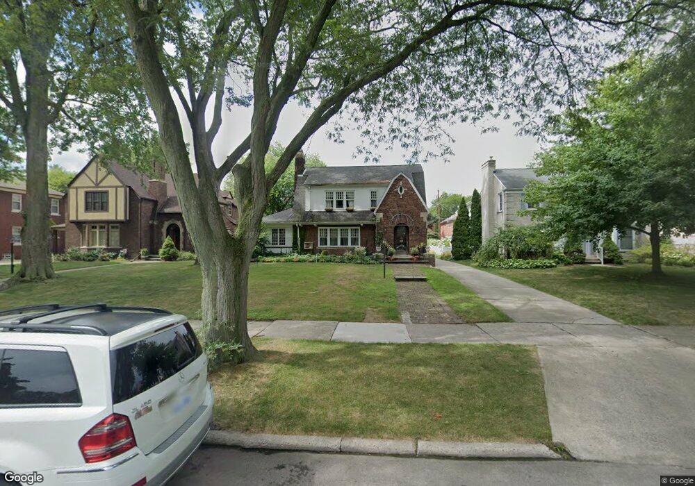
947 Westchester Rd Grosse Pointe Park, MI 48230
Estimated Value: $438,000 - $669,000
3
Beds
3
Baths
2,324
Sq Ft
$228/Sq Ft
Est. Value
About This Home
This home is located at 947 Westchester Rd, Grosse Pointe Park, MI 48230 and is currently estimated at $529,216, approximately $227 per square foot. 947 Westchester Rd is a home located in Wayne County with nearby schools including Pierce Middle School, Grosse Pointe South High School, and Detroit Merit Charter Academy.
Ownership History
Date
Name
Owned For
Owner Type
Purchase Details
Closed on
Nov 22, 2011
Sold by
Estate Of Mary M Segner
Bought by
Hallmann Heidi J
Current Estimated Value
Create a Home Valuation Report for This Property
The Home Valuation Report is an in-depth analysis detailing your home's value as well as a comparison with similar homes in the area
Home Values in the Area
Average Home Value in this Area
Purchase History
| Date | Buyer | Sale Price | Title Company |
|---|---|---|---|
| Hallmann Heidi J | $135,000 | Fidelity Natl Title Ins Co |
Source: Public Records
Tax History Compared to Growth
Tax History
| Year | Tax Paid | Tax Assessment Tax Assessment Total Assessment is a certain percentage of the fair market value that is determined by local assessors to be the total taxable value of land and additions on the property. | Land | Improvement |
|---|---|---|---|---|
| 2025 | $4,764 | $267,200 | $0 | $0 |
| 2024 | $4,764 | $257,800 | $0 | $0 |
| 2023 | $4,549 | $235,800 | $0 | $0 |
| 2022 | $4,322 | $229,500 | $0 | $0 |
| 2021 | $8,522 | $225,400 | $0 | $0 |
| 2019 | $8,770 | $208,500 | $0 | $0 |
| 2018 | $4,121 | $193,300 | $0 | $0 |
| 2017 | $9,226 | $124,900 | $0 | $0 |
| 2016 | $8,612 | $171,300 | $0 | $0 |
| 2015 | $15,422 | $168,400 | $0 | $0 |
| 2013 | $14,940 | $152,200 | $0 | $0 |
| 2012 | $3,175 | $160,600 | $46,400 | $114,200 |
Source: Public Records
Map
Nearby Homes
- 15501 E Jefferson Ave
- 74 Pointe Park Place Unit 311
- 54 Pointe Park Place Unit 208
- 1032 Beaconsfield Ave
- 1058 Lakepointe St
- 1048 Lakepointe St Unit A
- 1081 Lakepointe St
- 1056 Balfour St
- 1083 Lakepointe St
- 847 Barrington Rd
- 674 Alter Rd
- 709 Ashland St
- 908 Manistique St
- 877 Manistique St
- 807 Barrington Rd
- 814 Harcourt Rd Unit 816
- 504 Alter Rd
- 14536 E Jefferson Ave
- 709 Lakepointe St
- 1308 Ashland St
- 958 Nottingham Rd Unit 960
- 954 Nottingham Rd Unit 956
- 953 Westchester Rd
- 950 Nottingham Rd Unit 952
- 962 Nottingham Rd Unit 964
- 941 Westchester Rd
- 968 Nottingham Rd
- 946 Nottingham Rd Unit 948
- 966 Nottingham Rd Unit 968
- 956 Nottingham Rd
- 961 Westchester Rd
- 935 Westchester Rd
- 920 Nottingham Rd
- 928 Nottingham Rd
- 914 Nottingham Rd
- 952 Nottingham Rd
- 920 Nottingham Rd Unit 1
- 920 Nottingham Rd
- 980 Nottingham Rd
- 936 Nottingham Rd