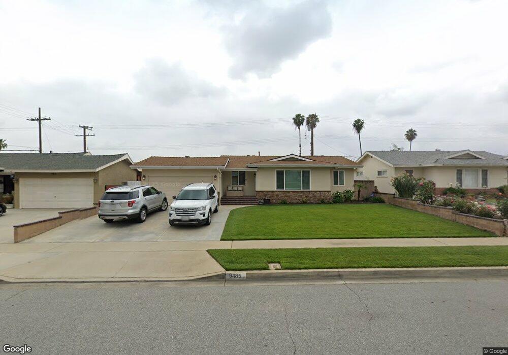
9485 Palo Alto St Rancho Cucamonga, CA 91730
Estimated Value: $629,410 - $716,000
3
Beds
2
Baths
1,151
Sq Ft
$594/Sq Ft
Est. Value
About This Home
This home is located at 9485 Palo Alto St, Rancho Cucamonga, CA 91730 and is currently estimated at $683,603, approximately $593 per square foot. 9485 Palo Alto St is a home located in San Bernardino County with nearby schools including Central Elementary, Cucamonga Middle, and Alta Loma High.
Ownership History
Date
Name
Owned For
Owner Type
Purchase Details
Closed on
Aug 18, 2010
Sold by
Hotchkiss Edward S
Bought by
Franco Ricardo U and Franco Arlene M
Current Estimated Value
Home Financials for this Owner
Home Financials are based on the most recent Mortgage that was taken out on this home.
Original Mortgage
$248,651
Outstanding Balance
$164,049
Interest Rate
4.5%
Mortgage Type
FHA
Estimated Equity
$519,554
Create a Home Valuation Report for This Property
The Home Valuation Report is an in-depth analysis detailing your home's value as well as a comparison with similar homes in the area
Home Values in the Area
Average Home Value in this Area
Purchase History
| Date | Buyer | Sale Price | Title Company |
|---|---|---|---|
| Franco Ricardo U | $252,000 | Ticor Title Company |
Source: Public Records
Mortgage History
| Date | Status | Borrower | Loan Amount |
|---|---|---|---|
| Open | Franco Ricardo U | $248,651 |
Source: Public Records
Tax History Compared to Growth
Tax History
| Year | Tax Paid | Tax Assessment Tax Assessment Total Assessment is a certain percentage of the fair market value that is determined by local assessors to be the total taxable value of land and additions on the property. | Land | Improvement |
|---|---|---|---|---|
| 2025 | $3,448 | $322,859 | $112,745 | $210,114 |
| 2024 | $3,448 | $316,528 | $110,534 | $205,994 |
| 2023 | $3,372 | $310,322 | $108,367 | $201,955 |
| 2022 | $3,317 | $304,237 | $106,242 | $197,995 |
| 2021 | $3,315 | $298,272 | $104,159 | $194,113 |
| 2020 | $3,220 | $295,214 | $103,091 | $192,123 |
| 2019 | $3,203 | $289,426 | $101,070 | $188,356 |
| 2018 | $3,112 | $283,751 | $99,088 | $184,663 |
| 2017 | $3,055 | $278,187 | $97,145 | $181,042 |
| 2016 | $3,017 | $272,732 | $95,240 | $177,492 |
| 2015 | $2,984 | $268,635 | $93,809 | $174,826 |
| 2014 | $2,897 | $263,372 | $91,971 | $171,401 |
Source: Public Records
Map
Nearby Homes
- 7534 Layton St
- 7430 Leucite Ave
- 7315 Klusman Ave
- 7730 Layton St
- 9599 Church St
- 7795 Malachite Ave
- 7420 London Ave
- 7236 Hellman Ave
- 9684 Hemlock St
- 9800 Base Line Rd Unit 79
- 9118 Baseline Rd
- 7678 Ramona Ave
- 9929 Palo Alto St
- 9764 Louise Way
- 9765 Louise Way
- 9706 Bodega Ct
- 7087 Hellman Ave
- 9800 Baseline Rd Unit 71
- 9800 Baseline Rd Unit 17
- 9800 Baseline Rd Unit 82
- 9475 Palo Alto St
- 9495 Palo Alto St
- 9496 Balsa St
- 9465 Palo Alto St
- 9505 Palo Alto St
- 9476 Balsa St
- 9510 Balsa St
- 9494 Palo Alto St
- 9466 Balsa St
- 9484 Palo Alto St
- 9515 Palo Alto St
- 9455 Palo Alto St
- 9474 Palo Alto St
- 9510 Palo Alto St
- 9456 Balsa St
- 9520 Balsa St
- 9525 Palo Alto St
- 9445 Palo Alto St
- 7531 Amethyst Ave
- 9464 Palo Alto St