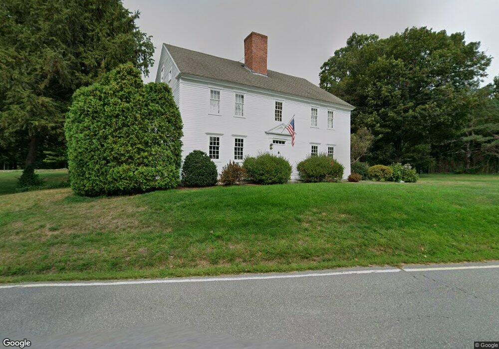
95 N River Rd Milford, NH 03055
Estimated Value: $684,000 - $872,000
4
Beds
2
Baths
3,070
Sq Ft
$259/Sq Ft
Est. Value
About This Home
This home is located at 95 N River Rd, Milford, NH 03055 and is currently estimated at $795,452, approximately $259 per square foot. 95 N River Rd is a home with nearby schools including Jacques Memorial Elementary School, Heron Pond Elementary School, and Milford Middle School.
Ownership History
Date
Name
Owned For
Owner Type
Purchase Details
Closed on
Dec 18, 2019
Sold by
James Brandy T
Bought by
Trombly Starr S
Current Estimated Value
Purchase Details
Closed on
Oct 4, 2016
Sold by
Trombly Land T
Bought by
125 Properties Llc
Purchase Details
Closed on
Jun 28, 2005
Sold by
Augusta F Law Rev T
Bought by
Trombly Starr S
Home Financials for this Owner
Home Financials are based on the most recent Mortgage that was taken out on this home.
Original Mortgage
$541,500
Interest Rate
5.82%
Mortgage Type
Purchase Money Mortgage
Create a Home Valuation Report for This Property
The Home Valuation Report is an in-depth analysis detailing your home's value as well as a comparison with similar homes in the area
Home Values in the Area
Average Home Value in this Area
Purchase History
| Date | Buyer | Sale Price | Title Company |
|---|---|---|---|
| Trombly Starr S | -- | None Available | |
| 125 Properties Llc | $260,000 | -- | |
| Trombly Starr S | $625,000 | -- |
Source: Public Records
Mortgage History
| Date | Status | Borrower | Loan Amount |
|---|---|---|---|
| Previous Owner | Trombly Starr S | $40,000 | |
| Previous Owner | Trombly Starr S | $541,500 |
Source: Public Records
Tax History Compared to Growth
Tax History
| Year | Tax Paid | Tax Assessment Tax Assessment Total Assessment is a certain percentage of the fair market value that is determined by local assessors to be the total taxable value of land and additions on the property. | Land | Improvement |
|---|---|---|---|---|
| 2024 | $16,242 | $686,200 | $100,800 | $585,400 |
| 2023 | $13,765 | $620,900 | $100,800 | $520,100 |
| 2022 | $12,909 | $620,900 | $100,800 | $520,100 |
| 2021 | $12,511 | $620,900 | $100,800 | $520,100 |
| 2020 | $13,256 | $522,500 | $84,600 | $437,900 |
| 2019 | $13,569 | $522,500 | $84,600 | $437,900 |
| 2018 | $12,657 | $433,000 | $84,600 | $348,400 |
| 2017 | $12,726 | $433,000 | $84,600 | $348,400 |
| 2016 | $12,592 | $434,800 | $86,400 | $348,400 |
| 2015 | $12,361 | $432,800 | $86,400 | $346,400 |
| 2014 | $11,815 | $432,800 | $86,400 | $346,400 |
| 2013 | $11,673 | $432,800 | $86,400 | $346,400 |
Source: Public Records
Map
Nearby Homes
- 229 Mont Vernon Rd
- 3 Abby Ln Unit 2
- 57 Patch Hill Ln
- 30 Perkins St Unit 1
- 18 Adams St
- 0 Briar Cliff Dr
- 344 Elm St Unit 16
- 64 Lyndeborough Rd
- 131 Homestead Cir
- 32 Larch Rd
- 24 Spaulding St
- 145 Westchester Dr
- 51 Singer Brook Rd
- 40 North St
- 43 Boxwood Cir
- 61 W Meadow Ct
- 26 Oak St
- 80 Christian Hill Rd
- 44 Osgood Rd
- 545 Elm St Unit 34
- 196 Mont Vernon Rd
- 26 Buxton Rd
- 16 Buxton Rd
- 61 N River Rd
- 10 Buxton Rd
- 17 Hutchinson Dr
- 145 N River Rd
- 190 Mont Vernon Rd
- 216 Mont Vernon Rd
- 210 Mont Vernon Rd
- 51 N River Rd
- 198 Mont Vernon Rd
- 155 N River Rd
- 148 N River Rd
- 1 Patch Hill Ln
- 14 Patch Hill Ln Unit 1
- 205 Mont Vernon Rd
- 165 N River Rd
- 211 Mont Vernon Rd
- 211 Mont Vernon Rd