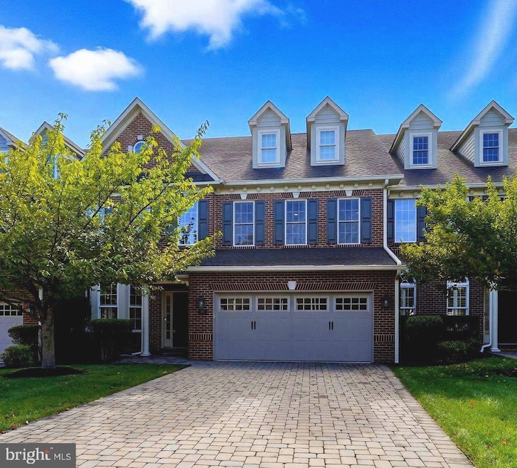
95 Rittenhouse Cir Unit 92 Newtown, PA 18940
Estimated payment $7,373/month
Highlights
- Fitness Center
- Eat-In Gourmet Kitchen
- Carriage House
- Active Adult
- View of Trees or Woods
- Clubhouse
About This Home
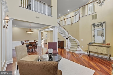
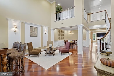
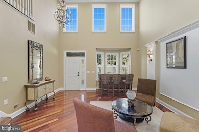
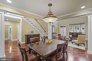
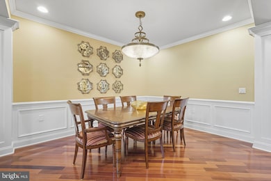
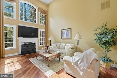
Welcome to this elegant residence in the highly sought-after Delancey Court community of Newtown Township. Blending sophistication with modern comfort, this home offers a prime location and beautifully designed living spaces throughout. The two-story foyer sets the tone with a grand circular staircase, gorgeous, gleaming hardwood floors that lead to an open-concept main level ideal for both entertaining and everyday living. The gourmet kitchen is a chef’s delight, featuring stainless steel appliances, custom cabinetry, granite countertops, and island seating. A sunlit breakfast area offers a casual dining space, while the formal dining room is ideally suited for hosting dinner parties and special occasions. The spacious family room, complete with a gas fireplace and soaring ceilings, creates a warm and inviting gathering place.
In contrast, the formal living room is filled with natural light and charming views of the landscaped surroundings. The large, luxurious primary suite showcases a tray ceiling, ample closet space, and a spa-inspired bath with a soaking tub, upgraded tile finishes, and oversized walk-in shower. Upstairs, two additional bedrooms share a well-appointed full bath. At the same time, the large loft area is complete with a sofa, chair, reading area, and entertainment unit, offering a versatile space for relaxation on the second level. The highlight of the third level is a private home theater, with stadium seating designed for the ultimate entertainment experience. Throughout the home, recessed lighting enhances every room, adding both style and functionality. Outdoor living is equally impressive with lush landscaping, manicured grounds, and a private paver patio that offers peaceful views of the woods—an ideal setting for grilling, dining, or simply enjoying the natural surroundings. This stunning property combines elegance, comfort, and convenience in one of Newtown Township’s most desirable communities. Living in Delancey Court means access to a spectacular clubhouse featuring both indoor and outdoor pools, a state-of-the-art fitness center, game room, and more—it’s like enjoying a luxury resort year-round. 55 Plus community.
Listing Agent
(215) 669-7720 janecolletti@gmail.com Legacy Realty Properties, LLC License #AB068833 Listed on: 09/27/2025
Co-Listing Agent
(215) 399-8184 vincentcolletti92@gmail.com Legacy Realty Properties, LLC
Open House Schedule
-
Saturday, November 29, 202511:00 am to 1:00 pm11/29/2025 11:00:00 AM +00:0011/29/2025 1:00:00 PM +00:00Add to Calendar
Townhouse Details
Home Type
- Townhome
Est. Annual Taxes
- $11,007
Year Built
- Built in 2007
Lot Details
- 3,382 Sq Ft Lot
- Stone Retaining Walls
- Back Yard Fenced
- Extensive Hardscape
- Backs to Trees or Woods
- Property is in excellent condition
HOA Fees
- $400 Monthly HOA Fees
Parking
- 2 Car Direct Access Garage
- Front Facing Garage
- Garage Door Opener
- Driveway
- Parking Lot
Home Design
- Carriage House
- Slab Foundation
- Frame Construction
- Pitched Roof
- Shingle Roof
Interior Spaces
- 3,326 Sq Ft Home
- Property has 3 Levels
- Chair Railings
- Crown Molding
- Wainscoting
- Tray Ceiling
- Two Story Ceilings
- Recessed Lighting
- Gas Fireplace
- Window Treatments
- Family Room Off Kitchen
- Combination Dining and Living Room
- Loft
- Views of Woods
- Alarm System
Kitchen
- Eat-In Gourmet Kitchen
- Breakfast Room
- Gas Oven or Range
- Self-Cleaning Oven
- Built-In Range
- Range Hood
- Built-In Microwave
- Dishwasher
- Stainless Steel Appliances
- Kitchen Island
- Upgraded Countertops
- Disposal
Flooring
- Wood
- Carpet
- Ceramic Tile
Bedrooms and Bathrooms
- En-Suite Bathroom
- Walk-In Closet
- Soaking Tub
- Bathtub with Shower
Laundry
- Laundry on main level
- Dryer
- Washer
Outdoor Features
- Patio
- Exterior Lighting
- Porch
Schools
- Newtown Elementary School
- Cr-Newtown Middle School
- Council Rock High School North
Utilities
- Forced Air Heating and Cooling System
- 200+ Amp Service
- Natural Gas Water Heater
Listing and Financial Details
- Tax Lot 034-092
- Assessor Parcel Number 29-003-034-092
Community Details
Overview
- Active Adult
- $3,000 Capital Contribution Fee
- Association fees include common area maintenance, lawn maintenance, management, pool(s), recreation facility, snow removal, trash, all ground fee
- Active Adult | Residents must be 55 or older
- Delancey Court HOA
- Built by McGrath
- Delancey Court Subdivision, Paxton Floorplan
- Property Manager
Amenities
- Common Area
- Clubhouse
- Game Room
- Billiard Room
- Meeting Room
Recreation
- Fitness Center
- Community Indoor Pool
Pet Policy
- Dogs and Cats Allowed
Map
Home Values in the Area
Average Home Value in this Area
Tax History
| Year | Tax Paid | Tax Assessment Tax Assessment Total Assessment is a certain percentage of the fair market value that is determined by local assessors to be the total taxable value of land and additions on the property. | Land | Improvement |
|---|---|---|---|---|
| 2025 | $10,788 | $60,700 | $4,000 | $56,700 |
| 2024 | $10,788 | $60,700 | $4,000 | $56,700 |
| 2023 | $10,321 | $60,700 | $4,000 | $56,700 |
| 2022 | $10,122 | $60,700 | $4,000 | $56,700 |
| 2021 | $9,964 | $60,700 | $4,000 | $56,700 |
| 2020 | $9,484 | $60,700 | $4,000 | $56,700 |
| 2019 | $9,260 | $60,700 | $4,000 | $56,700 |
| 2018 | $9,084 | $60,700 | $4,000 | $56,700 |
| 2017 | $8,769 | $60,700 | $4,000 | $56,700 |
| 2016 | $8,709 | $60,700 | $4,000 | $56,700 |
| 2015 | -- | $60,700 | $4,000 | $56,700 |
| 2014 | -- | $60,700 | $4,000 | $56,700 |
Property History
| Date | Event | Price | List to Sale | Price per Sq Ft |
|---|---|---|---|---|
| 09/27/2025 09/27/25 | For Sale | $1,150,000 | -- | $346 / Sq Ft |
Purchase History
| Date | Type | Sale Price | Title Company |
|---|---|---|---|
| Interfamily Deed Transfer | -- | Settlement Engine Inc | |
| Deed | $4,975,050 | None Available | |
| Deed | $654,990 | None Available |
Mortgage History
| Date | Status | Loan Amount | Loan Type |
|---|---|---|---|
| Open | $192,000 | Adjustable Rate Mortgage/ARM | |
| Previous Owner | $200,000 | Purchase Money Mortgage |
Source: Bright MLS
MLS Number: PABU2105892
APN: 29-003-034-092
Disclaimer: Certain information contained herein is derived from information provided by parties other than Homes.com. All information provided is deemed reliable, but is not guaranteed to be accurate and should be independently verified.
![]() The data relating to real estate for sale on this website appears in part through the BRIGHT Internet Data Exchange program, a voluntary cooperative exchange of property listing data between licensed real estate brokerage firms, and is provided by BRIGHT through a licensing agreement.
The data relating to real estate for sale on this website appears in part through the BRIGHT Internet Data Exchange program, a voluntary cooperative exchange of property listing data between licensed real estate brokerage firms, and is provided by BRIGHT through a licensing agreement.
Listing information is from various brokers who participate in the Bright MLS IDX program and not all listings may be visible on the site.
The property information being provided on or through the website is for the personal, non-commercial use of consumers and such information may not be used for any purpose other than to identify prospective properties consumers may be interested in purchasing.
Some properties which appear for sale on the website may no longer be available because they are for instance, under contract, sold or are no longer being offered for sale.
Property information displayed is deemed reliable but is not guaranteed.
Copyright 2025 Bright MLS, Inc.
- 35 Elfreths Ct
- 3202 Society Place
- 13 Sparrow Walk
- 3104 Society Place Unit B2
- 702 Society Place Unit A2
- 401 Society Place Unit A1
- Raintree Plan at Lyondale Meadows
- Kingswood Plan at Lyondale Meadows
- Cloverfield Plan at Lyondale Meadows
- Laney Plan at Lyondale Meadows
- Mayweather Plan at Lyondale Meadows
- Rollins Plan at Lyondale Meadows
- 0 Augusta Dr Unit KINGSWOOD
- 0 Augusta Dr Unit MAYWEATHER
- 0 Augusta Dr Unit RAINTREE
- 0 Augusta Dr Unit CLOVERFIELD
- 0 Augusta Dr Unit ROLLINS
- 0 Augusta Dr Unit LANEY
- 102 Broadleaf Place
- 101 Laurel Cir
- 1615 Society Place Unit 20E1
- 1001 Society Place Unit A1
- 232 Wrights Rd
- 793 Penns Park Rd Unit B
- 200 N Sycamore St Unit 2A
- 200 N Sycamore St Unit 2I
- 301 Edgeboro Dr Unit 2
- 114 Frost Ln
- 32 S State St Unit 2
- 33 Everett Dr
- 101 Cambridge Ln
- 2105 2nd Street Pike Unit 2105A
- 111 S State St
- 337 S Lincoln Ave
- 36 Fieldstone Dr
- 11 Hillcroft Way
- 41 Heather Ct
- 15 Northrup Ct
- 105 Hopkins Ct Unit 744A
- 2943 Windy Bush Rd
