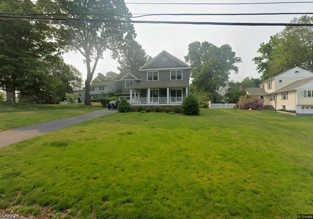
95 Shady Hill Rd Fairfield, CT 06824
University NeighborhoodEstimated Value: $1,412,000 - $1,527,044
4
Beds
4
Baths
2,800
Sq Ft
$531/Sq Ft
Est. Value
About This Home
This home is located at 95 Shady Hill Rd, Fairfield, CT 06824 and is currently estimated at $1,487,761, approximately $531 per square foot. 95 Shady Hill Rd is a home located in Fairfield County with nearby schools including Osborn Hill Elementary School, Fairfield Woods Middle School, and Fairfield Ludlowe High School.
Ownership History
Date
Name
Owned For
Owner Type
Purchase Details
Closed on
Jul 22, 2019
Sold by
Emmendorger Melissa M
Bought by
Emmendorfer Thomas M
Current Estimated Value
Purchase Details
Closed on
Aug 5, 2003
Sold by
Dzredzik Jan
Bought by
Emmcadortor Thomas and Emmcadorfor Melessa M
Home Financials for this Owner
Home Financials are based on the most recent Mortgage that was taken out on this home.
Original Mortgage
$425,000
Interest Rate
5.28%
Create a Home Valuation Report for This Property
The Home Valuation Report is an in-depth analysis detailing your home's value as well as a comparison with similar homes in the area
Home Values in the Area
Average Home Value in this Area
Purchase History
| Date | Buyer | Sale Price | Title Company |
|---|---|---|---|
| Emmendorfer Thomas M | -- | -- | |
| Emmendorfer Thomas M | -- | -- | |
| Emmcadortor Thomas | $819,000 | -- | |
| Emmcadortor Thomas | $819,000 | -- |
Source: Public Records
Mortgage History
| Date | Status | Borrower | Loan Amount |
|---|---|---|---|
| Previous Owner | Emmcadortor Thomas | $200,000 | |
| Previous Owner | Emmcadortor Thomas | $280,000 | |
| Previous Owner | Emmcadortor Thomas | $350,000 | |
| Previous Owner | Emmcadortor Thomas | $425,000 |
Source: Public Records
Tax History Compared to Growth
Tax History
| Year | Tax Paid | Tax Assessment Tax Assessment Total Assessment is a certain percentage of the fair market value that is determined by local assessors to be the total taxable value of land and additions on the property. | Land | Improvement |
|---|---|---|---|---|
| 2025 | $18,788 | $661,780 | $329,910 | $331,870 |
| 2024 | $18,464 | $661,780 | $329,910 | $331,870 |
| 2023 | $18,206 | $661,780 | $329,910 | $331,870 |
| 2022 | $18,027 | $661,780 | $329,910 | $331,870 |
| 2021 | $17,855 | $661,780 | $329,910 | $331,870 |
| 2020 | $17,802 | $664,510 | $326,410 | $338,100 |
| 2019 | $17,802 | $664,510 | $326,410 | $338,100 |
| 2018 | $17,516 | $664,510 | $326,410 | $338,100 |
| 2017 | $17,158 | $664,510 | $326,410 | $338,100 |
| 2016 | $16,912 | $664,510 | $326,410 | $338,100 |
| 2015 | $16,999 | $685,720 | $344,190 | $341,530 |
| 2014 | $16,732 | $685,720 | $344,190 | $341,530 |
Source: Public Records
Map
Nearby Homes
- 1207 Stillson Rd
- 1165 Stillson Rd
- 1137 Stillson Rd
- 2107 N Benson Rd
- 338 Orchard Hill Ln
- 359 Reid St
- 25 Millspaugh Dr
- 42 Robin Cir
- 45 Robin Cir
- 115 Mayfair Rd
- 33 Middlebrook Place
- 79 Mayfair Rd
- 66 Adams Rd
- 706 Judd St
- 210 Pansy Rd
- 44 Deer Run Rd
- 28 Stillson Place
- 68 Figlar Ave
- 41 Pepperbush Ln
- 105 Charter Oak Rd
- 67 Shady Hill Rd
- 115 Shady Hill Rd
- 112 Shady Hill Rd
- 131 Shady Hill Rd
- 30 Shady Hill Rd
- 90 Shady Hill Rd
- 80 Margemere Dr
- 128 Shady Hill Rd
- 46 Margemere Dr
- 116 Oxbow Rd
- 151 Shady Hill Rd
- 25 Shady Hill Rd
- 148 Shady Hill Rd
- 1847 N Benson Rd
- 87 Oxbow Rd
- 1851 N Benson Rd
- 175 Shady Hill Rd
- 100 Oxbow Rd
- 11 Shady Hill Rd
- 170 Shady Hill Rd