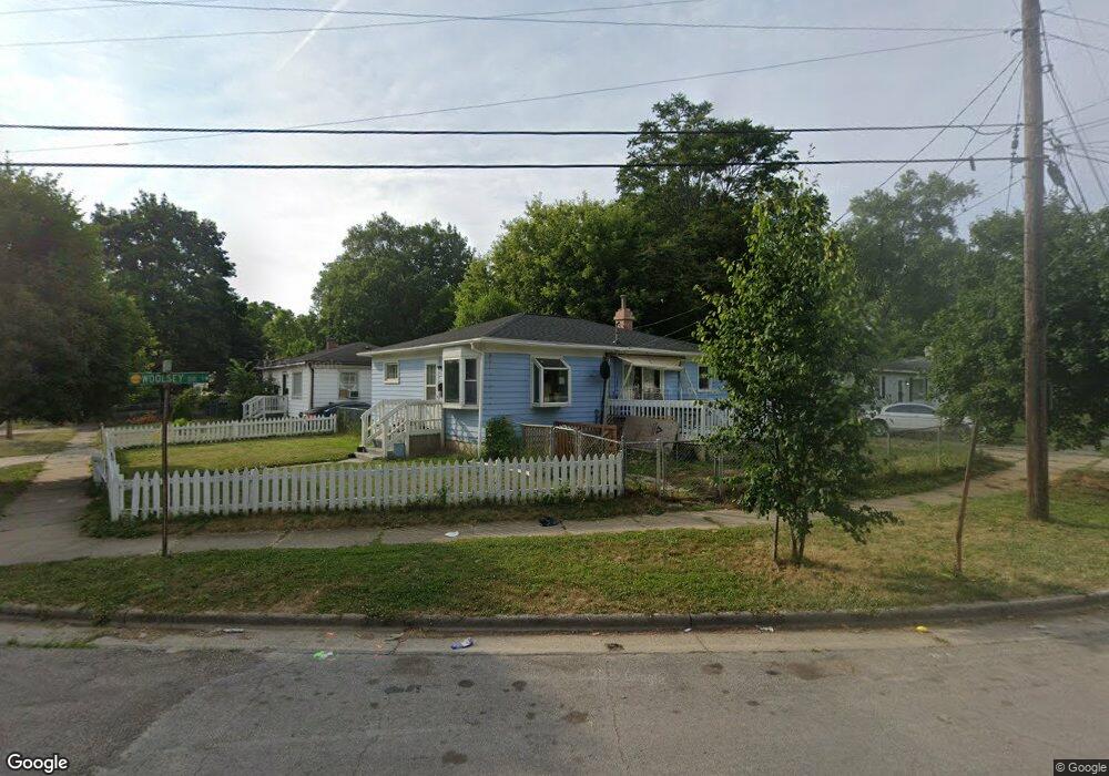
950 Oxford St SW Grand Rapids, MI 49503
Black Hills NeighborhoodEstimated Value: $177,106 - $217,000
3
Beds
1
Bath
1
Sq Ft
$201,777/Sq Ft
Est. Value
About This Home
This home is located at 950 Oxford St SW, Grand Rapids, MI 49503 and is currently estimated at $201,777, approximately $201,777 per square foot. 950 Oxford St SW is a home located in Kent County with nearby schools including Southwest Elementary School, Burton Middle School, and Union High School.
Ownership History
Date
Name
Owned For
Owner Type
Purchase Details
Closed on
May 4, 1994
Sold by
Kazma Richard R
Bought by
Swindall Cassandra L Trust and Swindall Cassandra L Trust
Current Estimated Value
Purchase Details
Closed on
Jul 9, 1991
Sold by
Kazma Kazma S S and Kazma R
Bought by
Swindall Cassandra L Trust
Purchase Details
Closed on
Dec 19, 1983
Sold by
Kazma Kazma L L and Kazma R
Bought by
Swindall Cassandra L Trust
Purchase Details
Closed on
Jun 24, 1980
Create a Home Valuation Report for This Property
The Home Valuation Report is an in-depth analysis detailing your home's value as well as a comparison with similar homes in the area
Home Values in the Area
Average Home Value in this Area
Purchase History
| Date | Buyer | Sale Price | Title Company |
|---|---|---|---|
| Swindall Cassandra L Trust | $39,000 | -- | |
| Swindall Cassandra L Trust | -- | -- | |
| Swindall Cassandra L Trust | $19,600 | -- | |
| -- | $19,000 | -- |
Source: Public Records
Tax History Compared to Growth
Tax History
| Year | Tax Paid | Tax Assessment Tax Assessment Total Assessment is a certain percentage of the fair market value that is determined by local assessors to be the total taxable value of land and additions on the property. | Land | Improvement |
|---|---|---|---|---|
| 2025 | $706 | $86,400 | $0 | $0 |
| 2024 | $706 | $69,400 | $0 | $0 |
| 2023 | $717 | $55,800 | $0 | $0 |
| 2022 | $913 | $50,400 | $0 | $0 |
| 2021 | $1,021 | $41,500 | $0 | $0 |
| 2020 | $987 | $32,700 | $0 | $0 |
| 2019 | $1,010 | $28,200 | $0 | $0 |
| 2018 | $980 | $25,500 | $0 | $0 |
| 2017 | $956 | $19,000 | $0 | $0 |
| 2016 | $960 | $17,900 | $0 | $0 |
| 2015 | $915 | $17,900 | $0 | $0 |
| 2013 | -- | $18,600 | $0 | $0 |
Source: Public Records
Map
Nearby Homes
- 543 Tenhaaf Ct SW
- 841 Oakland Ave SW
- 730 Liberty St SW
- 721 Olympia St SW
- 757 Tulip St SW
- 962 Sheridan Ave SW
- 335 Krakow Place SW
- 719 Coate Ct SW
- 540 New Ave SW
- 530 New Ave SW
- 448 Pleasant St SW
- 452 Pleasant St SW
- 444 Pleasant St SW
- 440 Pleasant St SW
- 436 Pleasant St SW
- 318 Hogadone Ave SW
- 934 Butterworth St SW
- 601 High St SW
- 1405 Marquette St SW
- 210 Mardell Place SW
- 946 Oxford St SW
- 910 Woolsey Dr SW
- 940 Oxford St SW
- 916 Woolsey Dr SW
- 921 Woolsey Dr SW
- 873 Woolsey Dr SW
- 909 Woolsey Dr SW
- 929 Woolsey Dr SW
- 901 Woolsey Dr SW
- 911 Merrill Ave SW
- 920 Woolsey Dr SW
- 937 Woolsey Dr SW
- 936 Oxford St SW
- 917 Merrill Ave SW
- 860 Woolsey Dr SW
- 926 Woolsey Dr SW
- 921 Merrill Ave SW
- 869 Woolsey Dr SW
- 933 Oxford St SW
- 930 Woolsey Dr SW