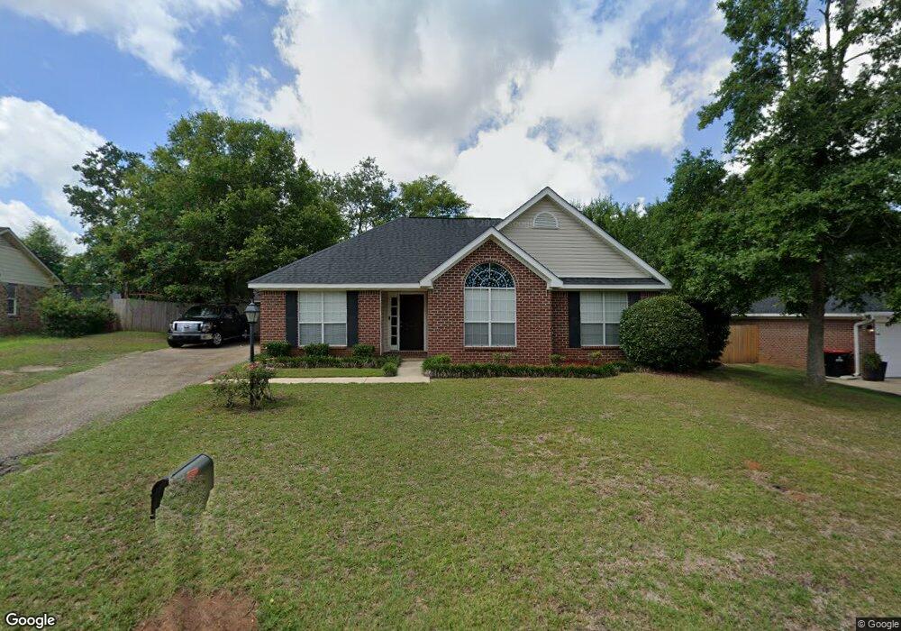
9511 Oak Forrest Dr Mobile, AL 36695
Baker NeighborhoodEstimated Value: $192,978 - $245,000
3
Beds
2
Baths
1,697
Sq Ft
$135/Sq Ft
Est. Value
About This Home
This home is located at 9511 Oak Forrest Dr, Mobile, AL 36695 and is currently estimated at $229,745, approximately $135 per square foot. 9511 Oak Forrest Dr is a home located in Mobile County with nearby schools including Elsie Collier Elementary School, Bernice J Causey Middle School, and Baker High School.
Ownership History
Date
Name
Owned For
Owner Type
Purchase Details
Closed on
Oct 20, 2003
Sold by
Shreves Gary L and Shreves Laura R
Bought by
Lloyd Michael T and Neel Jennifer L
Current Estimated Value
Home Financials for this Owner
Home Financials are based on the most recent Mortgage that was taken out on this home.
Original Mortgage
$108,537
Outstanding Balance
$50,023
Interest Rate
6.03%
Mortgage Type
Unknown
Estimated Equity
$179,722
Purchase Details
Closed on
Jan 22, 1999
Sold by
John Howard Homes Ltd
Bought by
Shreves Gary L and Shreves Laura R
Home Financials for this Owner
Home Financials are based on the most recent Mortgage that was taken out on this home.
Original Mortgage
$97,850
Interest Rate
6.71%
Create a Home Valuation Report for This Property
The Home Valuation Report is an in-depth analysis detailing your home's value as well as a comparison with similar homes in the area
Home Values in the Area
Average Home Value in this Area
Purchase History
| Date | Buyer | Sale Price | Title Company |
|---|---|---|---|
| Lloyd Michael T | $114,250 | -- | |
| Shreves Gary L | -- | -- |
Source: Public Records
Mortgage History
| Date | Status | Borrower | Loan Amount |
|---|---|---|---|
| Open | Lloyd Michael T | $108,537 | |
| Previous Owner | Shreves Gary L | $97,850 |
Source: Public Records
Tax History Compared to Growth
Tax History
| Year | Tax Paid | Tax Assessment Tax Assessment Total Assessment is a certain percentage of the fair market value that is determined by local assessors to be the total taxable value of land and additions on the property. | Land | Improvement |
|---|---|---|---|---|
| 2024 | $798 | $15,330 | $4,000 | $11,330 |
| 2023 | $747 | $14,930 | $4,000 | $10,930 |
| 2022 | $583 | $13,390 | $4,000 | $9,390 |
| 2021 | $573 | $13,190 | $4,000 | $9,190 |
| 2020 | $590 | $13,540 | $3,200 | $10,340 |
| 2019 | $592 | $13,580 | $0 | $0 |
| 2018 | $604 | $13,840 | $0 | $0 |
| 2017 | $613 | $12,580 | $0 | $0 |
| 2016 | $549 | $12,700 | $0 | $0 |
| 2013 | $627 | $13,460 | $0 | $0 |
Source: Public Records
Map
Nearby Homes
- 9410 Ashwood Ct
- 9556 Bridgeton Ct
- 9425 Yorktowne Way
- 0 New Neck Rd Unit 387066
- 1111 Valley View Ct
- 860 Trailwood Dr E
- 821 Copperfield Dr W
- 790 Hale Rd
- 791 Copperfield Dr W
- 781 Copperfield Dr W
- 789 Royal Woods Dr W Unit 7
- 9751 Pine Knoll Rd
- 750 Hale Rd
- 11905 Airport Blvd
- 11905 Airport Blvd Unit 3
- 11900 Airport Blvd
- 9721 Royal Woods Dr N
- 9841 Shadow Wood Dr
- 653 Begeman Rd
- 1235 Wakefield Dr E
- 9501 Oak Forrest Dr
- 9521 Oak Forrest Dr
- 9520 Signal Ct
- 9510 Signal Ct
- 9491 Oak Forrest Dr
- 9531 Oak Forrest Dr
- 9510 Oak Forrest Dr
- 9530 Signal Ct
- 9500 Signal Ct
- 9520 Oak Forest Dr
- 9490 Oak Forrest Dr
- 10453 Heritance Rd
- 15120 Private Rd Unit 368
- 9520 Oak Forrest Dr
- 9481 Oak Forrest Dr
- 9541 Oak Forrest Dr
- 9480 Signal Ct
- 9540 Signal Ct
- 9480 Oak Forrest Dr Unit 2
- 9530 Oak Forrest Dr