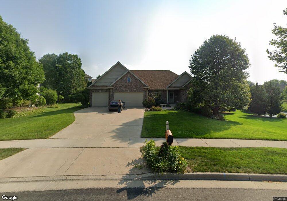
9518 Sandhill Rd Middleton, WI 53562
Town of Middleton NeighborhoodEstimated Value: $1,027,676 - $1,200,000
5
Beds
5
Baths
3,985
Sq Ft
$278/Sq Ft
Est. Value
About This Home
This home is located at 9518 Sandhill Rd, Middleton, WI 53562 and is currently estimated at $1,107,419, approximately $277 per square foot. 9518 Sandhill Rd is a home located in Dane County with nearby schools including Pope Farm Elementary School, Kromrey Middle School, and Middleton High School.
Ownership History
Date
Name
Owned For
Owner Type
Purchase Details
Closed on
Jun 24, 2009
Sold by
Wilckens Pablo A and Wilckens Colleen M
Bought by
Kushner Michael P and Kushner Megan A
Current Estimated Value
Home Financials for this Owner
Home Financials are based on the most recent Mortgage that was taken out on this home.
Original Mortgage
$387,200
Interest Rate
4.36%
Mortgage Type
New Conventional
Create a Home Valuation Report for This Property
The Home Valuation Report is an in-depth analysis detailing your home's value as well as a comparison with similar homes in the area
Home Values in the Area
Average Home Value in this Area
Purchase History
| Date | Buyer | Sale Price | Title Company |
|---|---|---|---|
| Kushner Michael P | $484,000 | None Available |
Source: Public Records
Mortgage History
| Date | Status | Borrower | Loan Amount |
|---|---|---|---|
| Previous Owner | Kushner Michael P | $387,200 |
Source: Public Records
Tax History Compared to Growth
Tax History
| Year | Tax Paid | Tax Assessment Tax Assessment Total Assessment is a certain percentage of the fair market value that is determined by local assessors to be the total taxable value of land and additions on the property. | Land | Improvement |
|---|---|---|---|---|
| 2024 | $27,513 | $830,100 | $310,400 | $519,700 |
| 2023 | $12,801 | $775,800 | $290,100 | $485,700 |
| 2021 | $11,900 | $613,300 | $229,400 | $383,900 |
| 2020 | $12,066 | $573,200 | $214,400 | $358,800 |
| 2019 | $11,805 | $562,000 | $210,200 | $351,800 |
| 2018 | $11,381 | $554,800 | $202,100 | $352,700 |
| 2017 | $11,962 | $554,800 | $202,100 | $352,700 |
| 2016 | $11,637 | $523,400 | $190,700 | $332,700 |
| 2015 | $12,208 | $498,500 | $181,600 | $316,900 |
| 2014 | $11,665 | $498,500 | $181,600 | $316,900 |
| 2013 | $10,624 | $484,000 | $176,300 | $307,700 |
Source: Public Records
Map
Nearby Homes
- 9230 Bear Claw Way
- 2 Greystone Cir
- 9121 Blackhawk Rd
- 9809 Trappers Trail
- 709 Cricket Ln Unit 2
- 711 Cricket Ln Unit 3
- 10013 Shadow Ridge Trail
- 661 Burnt Sienna Dr
- 630 Big Stone Trail
- 725 Schewe Rd
- 639 Schewe Rd
- 637 Schewe Rd
- 9423 Lost Meadow Rd
- 632 Tabby Turn Dr
- 9924 Shining Willow St
- 10120 Mosaic Way
- 423 Fargo Trail
- 10122 Mosaic Way
- 636 Tabby Turn Dr
- The Margot Plan at Eagle Trace
- 9526 Sandhill Rd
- 910 Bear Claw Way
- 906 Bear Claw Way
- 9258 Bear Claw Way
- 9506 Blue Heron Dr
- 9401 Blackhawk Rd
- 9534 Sandhill Rd
- 9517 Sandhill Rd
- 9254 Bear Claw Way
- 902 Bear Claw Way
- 9514 Blue Heron Dr
- 9409 Blackhawk Rd
- 9250 Bear Claw Way
- 9542 Sandhill Rd
- 9539 Sandhill Rd
- 9257 Bear Claw Way
- 909 Bear Claw Way
- 9409 Blackhawk Rd
- 9518 Blue Heron Dr
- 905 Bear Claw Way