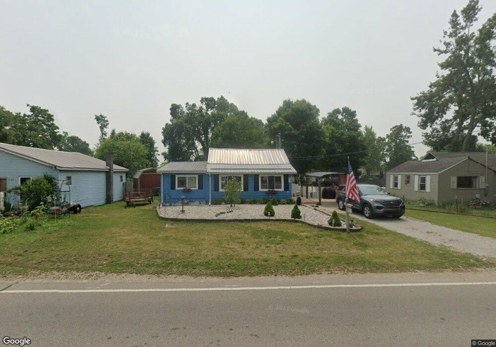
9523 W Weston Rd Morenci, MI 49256
Estimated Value: $98,813 - $114,000
2
Beds
1
Bath
1,160
Sq Ft
$93/Sq Ft
Est. Value
About This Home
This home is located at 9523 W Weston Rd, Morenci, MI 49256 and is currently estimated at $108,271, approximately $93 per square foot. 9523 W Weston Rd is a home located in Lenawee County with nearby schools including Morenci Elementary School and Morenci Middle/High School.
Ownership History
Date
Name
Owned For
Owner Type
Purchase Details
Closed on
Oct 5, 2012
Sold by
Secretary Of Hud
Bought by
Fonville Ronald
Current Estimated Value
Purchase Details
Closed on
Mar 12, 2012
Sold by
Wells Fargo Bank Na
Bought by
Secretary Of Hud
Purchase Details
Closed on
Dec 20, 2007
Sold by
Shadbolt Linda
Bought by
Lambright Jordon
Home Financials for this Owner
Home Financials are based on the most recent Mortgage that was taken out on this home.
Original Mortgage
$59,073
Interest Rate
6.27%
Mortgage Type
FHA
Create a Home Valuation Report for This Property
The Home Valuation Report is an in-depth analysis detailing your home's value as well as a comparison with similar homes in the area
Home Values in the Area
Average Home Value in this Area
Purchase History
| Date | Buyer | Sale Price | Title Company |
|---|---|---|---|
| Fonville Ronald | -- | None Available | |
| Secretary Of Hud | -- | None Available | |
| Lambright Jordon | $60,000 | Atcl |
Source: Public Records
Mortgage History
| Date | Status | Borrower | Loan Amount |
|---|---|---|---|
| Previous Owner | Lambright Jordon | $59,073 |
Source: Public Records
Tax History Compared to Growth
Tax History
| Year | Tax Paid | Tax Assessment Tax Assessment Total Assessment is a certain percentage of the fair market value that is determined by local assessors to be the total taxable value of land and additions on the property. | Land | Improvement |
|---|---|---|---|---|
| 2025 | $967 | $39,200 | $0 | $0 |
| 2024 | $312 | $38,600 | $0 | $0 |
| 2022 | $274 | $31,900 | $0 | $0 |
| 2021 | $856 | $27,600 | $0 | $0 |
| 2020 | $859 | $26,100 | $0 | $0 |
| 2019 | $67,717 | $22,800 | $0 | $0 |
| 2018 | $811 | $22,776 | $0 | $0 |
| 2017 | $785 | $22,039 | $0 | $0 |
| 2016 | $882 | $26,423 | $0 | $0 |
| 2014 | -- | $21,021 | $0 | $0 |
Source: Public Records
Map
Nearby Homes
- 328 E Main St
- 511 E Main St
- 507 Page St
- 402 Pearl St
- 13890 Rice Hwy
- 205 E Chestnut St
- 141 E Main St
- 136 E Chestnut St
- 128 E Lagrange St
- 403 N Summit St
- 221 N Summit St
- 114 W Walnut St
- 210 W Locust St
- 7540 W Weston Rd
- 10554 Hickory St
- 15383 County Road 19
- 16099 Us Highway 20
- 14640 County Road K
- 8288 Packard Rd
- 8058 Packard Rd
- 9523 W Weston Rd Unit WESTON
- 9537 W Weston Rd Unit BLK
- 9491 W Weston Rd
- 9559 W Weston Rd
- 9564 W Weston Rd
- 9613 W Weston Rd
- 9279 W Weston Rd
- 9481 W Weston Rd
- 9470 W Weston Rd
- 9463 W Weston Rd
- 9420 W Weston Rd
- 9389 W Weston Rd
- 9382 W Weston Rd
- 9355 W Weston Rd
- 9350 W Weston Rd
- 9324 W Weston Rd
- 9393 W Yankee Rd
- 9375 W Yankee Rd
- 0 W Weston Rd Unit 91649
- 0 W Weston Rd Unit WESTON