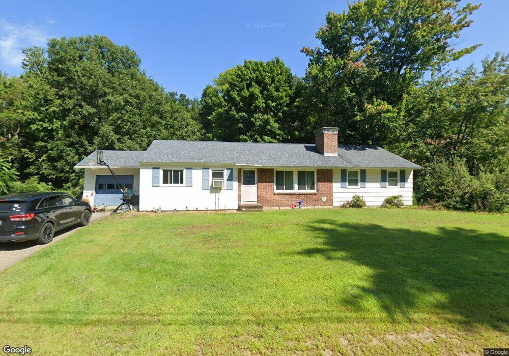
96 Woodland Ave Gilford, NH 03249
Estimated Value: $443,338 - $501,000
3
Beds
1
Bath
1,650
Sq Ft
$281/Sq Ft
Est. Value
About This Home
This home is located at 96 Woodland Ave, Gilford, NH 03249 and is currently estimated at $464,335, approximately $281 per square foot. 96 Woodland Ave is a home located in Belknap County with nearby schools including Gilford Elementary School, Gilford Middle School, and Gilford High School.
Ownership History
Date
Name
Owned For
Owner Type
Purchase Details
Closed on
Sep 16, 2022
Sold by
Dyer David A
Bought by
Marden Shannon L
Current Estimated Value
Home Financials for this Owner
Home Financials are based on the most recent Mortgage that was taken out on this home.
Original Mortgage
$225,000
Outstanding Balance
$214,523
Interest Rate
5%
Mortgage Type
Adjustable Rate Mortgage/ARM
Estimated Equity
$249,812
Purchase Details
Closed on
Mar 10, 2009
Sold by
Eleanor S Burt T
Bought by
Dyer John H and Dyer Shirley A
Create a Home Valuation Report for This Property
The Home Valuation Report is an in-depth analysis detailing your home's value as well as a comparison with similar homes in the area
Home Values in the Area
Average Home Value in this Area
Purchase History
| Date | Buyer | Sale Price | Title Company |
|---|---|---|---|
| Marden Shannon L | -- | None Available | |
| Marden Shannon L | -- | None Available | |
| Dyer John H | $167,600 | -- |
Source: Public Records
Mortgage History
| Date | Status | Borrower | Loan Amount |
|---|---|---|---|
| Open | Marden Shannon L | $225,000 | |
| Closed | Marden Shannon L | $225,000 |
Source: Public Records
Tax History Compared to Growth
Tax History
| Year | Tax Paid | Tax Assessment Tax Assessment Total Assessment is a certain percentage of the fair market value that is determined by local assessors to be the total taxable value of land and additions on the property. | Land | Improvement |
|---|---|---|---|---|
| 2024 | $4,393 | $390,490 | $130,390 | $260,100 |
| 2023 | $4,022 | $390,490 | $130,390 | $260,100 |
| 2022 | $3,355 | $273,860 | $80,860 | $193,000 |
| 2021 | $3,363 | $273,860 | $80,860 | $193,000 |
| 2020 | $3,514 | $239,000 | $75,300 | $163,700 |
| 2019 | $3,341 | $210,680 | $44,180 | $166,500 |
| 2018 | $3,219 | $188,900 | $50,200 | $138,700 |
| 2017 | $3,183 | $184,400 | $50,200 | $134,200 |
| 2016 | $3,177 | $177,000 | $50,200 | $126,800 |
| 2015 | $3,144 | $174,980 | $51,280 | $123,700 |
| 2011 | $2,973 | $160,250 | $56,350 | $103,900 |
Source: Public Records
Map
Nearby Homes
- 102 Woodland Ave
- 74 Morrill St
- 162 Morrill St
- 0 Sanborn St Unit 8 5059863
- 468 Union Ave
- 29 Strafford St
- 239 Gilford Ave
- Lot 1 Winter St
- 84 Spring St
- 7 Riverside Ct
- 7 Countryside Dr
- 96 Clinton St
- 30 Messer St
- 17 Arch St
- 44 Highland St
- 17 Rowell St
- 24 Mcgrath St
- 122 Valley St
- 6 Colonial Dr
- 42 Beaman St
- 90 Woodland Ave
- 93 Woodland Ave
- 95 Woodland Ave
- 106 Woodland Ave
- 76 Woodland Ave
- 101 Woodland Ave
- 73 Woodland Ave
- 112 Woodland Ave
- 109 Woodland Ave
- 7 Cottonwood Ave
- 113 Woodland Ave
- 60 Woodland Ave
- 116 Woodland Ave
- 17 Cottonwood Ave
- 59 Woodland Ave
- 23 Cottonwood Ave
- 1 Cottonwood Ave
- 29 McGuinness Ct
- 33 Cottonwood Ave
- 117 Woodland Ave