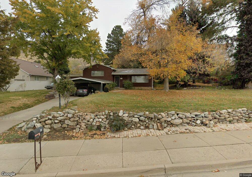
960 N 400 E Centerville, UT 84014
Estimated Value: $459,000 - $537,618
3
Beds
2
Baths
1,075
Sq Ft
$454/Sq Ft
Est. Value
About This Home
This home is located at 960 N 400 E, Centerville, UT 84014 and is currently estimated at $488,155, approximately $454 per square foot. 960 N 400 E is a home located in Davis County with nearby schools including Centerville Elementary, Centerville Jr High, and Viewmont High School.
Ownership History
Date
Name
Owned For
Owner Type
Purchase Details
Closed on
Nov 29, 2016
Sold by
Anderson Kenneth O and Anderson Melauna
Bought by
Anderson Melauna S and Anderson Trust
Current Estimated Value
Purchase Details
Closed on
Jun 5, 2000
Sold by
The Scott Group Llc
Bought by
Makris Ted G and Makris Pamela
Purchase Details
Closed on
Jan 21, 2000
Sold by
Cook James D and Cook Linda M
Bought by
The Scott Group Llc
Create a Home Valuation Report for This Property
The Home Valuation Report is an in-depth analysis detailing your home's value as well as a comparison with similar homes in the area
Purchase History
| Date | Buyer | Sale Price | Title Company |
|---|---|---|---|
| Anderson Melauna S | -- | None Available | |
| Makris Ted G | -- | Aspen Title Insurance Agency | |
| The Scott Group Llc | -- | Aspen Title Insurance Agency |
Source: Public Records
Tax History
| Year | Tax Paid | Tax Assessment Tax Assessment Total Assessment is a certain percentage of the fair market value that is determined by local assessors to be the total taxable value of land and additions on the property. | Land | Improvement |
|---|---|---|---|---|
| 2025 | $2,444 | $233,750 | $205,373 | $28,377 |
| 2024 | $2,318 | $225,500 | $196,153 | $29,347 |
| 2023 | $2,088 | $367,000 | $306,495 | $60,505 |
| 2022 | $2,176 | $210,650 | $157,830 | $52,820 |
| 2021 | $2,016 | $304,000 | $258,781 | $45,219 |
| 2020 | $1,798 | $271,000 | $243,559 | $27,441 |
| 2019 | $1,820 | $268,000 | $215,500 | $52,500 |
| 2018 | $1,684 | $245,000 | $198,488 | $46,512 |
| 2016 | $1,389 | $112,310 | $83,635 | $28,675 |
| 2015 | $1,362 | $103,840 | $83,635 | $20,205 |
| 2014 | $1,264 | $98,598 | $83,508 | $15,090 |
| 2013 | -- | $101,016 | $55,476 | $45,540 |
Source: Public Records
Map
Nearby Homes
- 984 N 500 E
- 1290 Oakridge Dr
- 66 Brookside Ln
- 563 N 220 E
- 1366 Cottonwood Dr
- 775 Pheasantbrook Cir
- 380 E 400 N
- 271 Brookfield Ln
- 292 W 680 N
- 781 Pheasantbrook Dr
- 281 W 650 N Unit B
- 282 W 605 N Unit A
- 282 W 605 N Unit I
- 252 N 400 E
- 371 W 1125 N
- 303 W 650 N Unit I
- 145 Ford Canyon Dr
- 290 W 1350 N
- 1238 N 450 W
- 56 W 200 N
- 990 N 400 E
- 440 E Chase Ln
- 971 Shadow Mountain Cir
- 957 Shadow Mountain Cir
- 930 N 400 E
- 991 N 400 E
- 985 N 400 E
- 943 Shadow Mountain Cir
- 975 N 400 E
- 995 N 400 E
- 1008 N 300 E
- 1011 Hughes St
- 988 Shadow Mountain Cir
- 880 N 400 E
- 925 N 400 E
- 1007 N 300 E
- 940 Shadow Mountain Cir
- 976 Shadow Mountain Cir
- 872 N 400 E
- 401 E Chase Ln
Your Personal Tour Guide
Ask me questions while you tour the home.