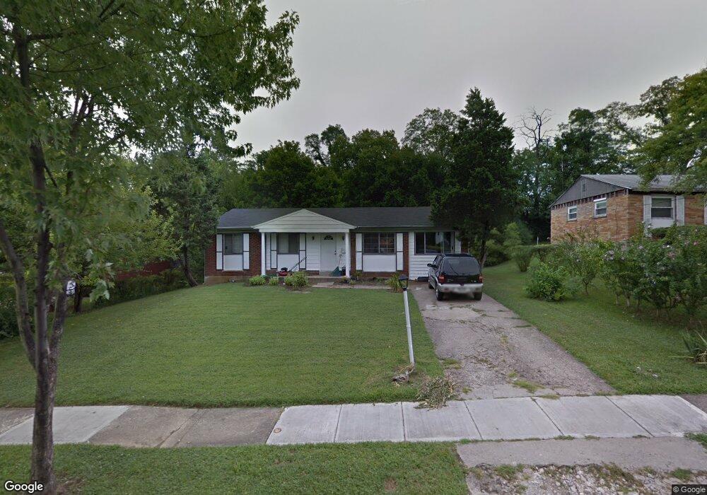
9606 Trafford Ct Cincinnati, OH 45231
Winton Lake NeighborhoodEstimated Value: $145,000 - $206,000
3
Beds
1
Bath
1,248
Sq Ft
$143/Sq Ft
Est. Value
About This Home
This home is located at 9606 Trafford Ct, Cincinnati, OH 45231 and is currently estimated at $178,221, approximately $142 per square foot. 9606 Trafford Ct is a home located in Hamilton County with nearby schools including Mt Healthy High School, Central Montessori Academy, and John Paul II Catholic School.
Ownership History
Date
Name
Owned For
Owner Type
Purchase Details
Closed on
Oct 29, 2010
Sold by
Mooney Charvell L
Bought by
Burke Minyette R and Washington Sandra
Current Estimated Value
Home Financials for this Owner
Home Financials are based on the most recent Mortgage that was taken out on this home.
Original Mortgage
$39,468
Outstanding Balance
$25,684
Interest Rate
4.31%
Mortgage Type
FHA
Estimated Equity
$152,537
Purchase Details
Closed on
Nov 17, 2003
Sold by
Estate Of Charles W Dyer
Bought by
Dyer Nettie B
Create a Home Valuation Report for This Property
The Home Valuation Report is an in-depth analysis detailing your home's value as well as a comparison with similar homes in the area
Home Values in the Area
Average Home Value in this Area
Purchase History
| Date | Buyer | Sale Price | Title Company |
|---|---|---|---|
| Burke Minyette R | $40,000 | Ltoc | |
| Dyer Nettie B | -- | -- |
Source: Public Records
Mortgage History
| Date | Status | Borrower | Loan Amount |
|---|---|---|---|
| Open | Burke Minyette R | $39,468 |
Source: Public Records
Tax History
| Year | Tax Paid | Tax Assessment Tax Assessment Total Assessment is a certain percentage of the fair market value that is determined by local assessors to be the total taxable value of land and additions on the property. | Land | Improvement |
|---|---|---|---|---|
| 2025 | $1,718 | $28,392 | $7,812 | $20,580 |
| 2023 | $1,621 | $28,392 | $7,812 | $20,580 |
| 2022 | $1,220 | $15,911 | $7,084 | $8,827 |
| 2021 | $1,187 | $15,911 | $7,084 | $8,827 |
| 2020 | $1,205 | $15,911 | $7,084 | $8,827 |
| 2019 | $1,093 | $13,483 | $6,003 | $7,480 |
| 2018 | $1,099 | $13,483 | $6,003 | $7,480 |
| 2017 | $1,043 | $13,483 | $6,003 | $7,480 |
| 2016 | $1,073 | $13,633 | $6,780 | $6,853 |
| 2015 | $1,080 | $13,633 | $6,780 | $6,853 |
| 2014 | $1,075 | $13,633 | $6,780 | $6,853 |
| 2013 | $1,106 | $14,351 | $7,137 | $7,214 |
Source: Public Records
Map
Nearby Homes
- 1405 Meredith Dr
- 1371 Summe Dr
- 1378 Adams Rd
- 8491 Daly Rd
- 9811 Beau Ln
- 1478 Bonneville Ln
- 7918 Southampton Ct
- 7849 Seward Ave
- 1457 Adams Rd
- 1559 Meredith Dr
- 1556 Meredith Dr
- 1123 Compton Rd
- 1115 Compton Rd
- 1579 Meredith Dr
- 9367 Stoneybrooke Unit 10G
- 9382 Stoneybrooke
- 9305 Bridgecreek Dr Unit 14A
- 9370 Bridgecreek Dr
- 946 Mckelvey Rd
- 8943 Monsanto Dr
- 9596 Trafford Ct
- 9618 Trafford Ct
- 9584 Trafford Ct
- 9630 Trafford Ct
- 9607 Trafford Ct
- 9572 Trafford Ct
- 9597 Trafford Ct
- 9617 Trafford Ct
- 9587 Trafford Ct
- 9627 Trafford Ct
- 9637 Trafford Ct
- 9640 Trafford Ct
- 9577 Trafford Ct
- 9647 Trafford Ct
- 9562 Trafford Ct
- 9650 Trafford Ct
- 9661 Daly Rd
- 9567 Trafford Ct
- 9550 Trafford Ct
- 9557 Trafford Ct
Your Personal Tour Guide
Ask me questions while you tour the home.