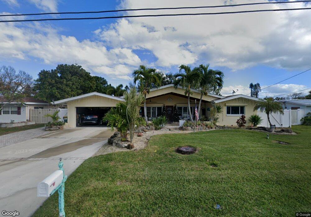
961 Bali Rd Cocoa Beach, FL 32931
Estimated Value: $681,000 - $1,096,000
3
Beds
2
Baths
1,840
Sq Ft
$484/Sq Ft
Est. Value
About This Home
This home is located at 961 Bali Rd, Cocoa Beach, FL 32931 and is currently estimated at $890,503, approximately $483 per square foot. 961 Bali Rd is a home located in Brevard County with nearby schools including Theodore Roosevelt Elementary School, Cocoa Beach Junior/Senior High School, and Cocoa Beach Christian School.
Ownership History
Date
Name
Owned For
Owner Type
Purchase Details
Closed on
Apr 16, 2021
Sold by
Stewart Donald A and Stewart Sheri
Bought by
Stewart Donald and Stewart Sheri
Current Estimated Value
Home Financials for this Owner
Home Financials are based on the most recent Mortgage that was taken out on this home.
Original Mortgage
$416,000
Outstanding Balance
$312,570
Interest Rate
3.05%
Mortgage Type
New Conventional
Estimated Equity
$577,933
Purchase Details
Closed on
Apr 30, 2004
Sold by
Stewart Susan S
Bought by
Stewart Donald
Purchase Details
Closed on
Oct 30, 1995
Sold by
Richardson John D and Richardson Linda Ann
Bought by
Stewart Donald A and Stewart Susan S
Home Financials for this Owner
Home Financials are based on the most recent Mortgage that was taken out on this home.
Original Mortgage
$151,000
Interest Rate
7.51%
Create a Home Valuation Report for This Property
The Home Valuation Report is an in-depth analysis detailing your home's value as well as a comparison with similar homes in the area
Home Values in the Area
Average Home Value in this Area
Purchase History
| Date | Buyer | Sale Price | Title Company |
|---|---|---|---|
| Stewart Donald | -- | Prestige Ttl Of Brevard Llc | |
| Stewart Donald | -- | -- | |
| Stewart Donald A | $188,900 | -- |
Source: Public Records
Mortgage History
| Date | Status | Borrower | Loan Amount |
|---|---|---|---|
| Open | Stewart Donald | $416,000 | |
| Previous Owner | Stewart Donald A | $151,000 |
Source: Public Records
Tax History
| Year | Tax Paid | Tax Assessment Tax Assessment Total Assessment is a certain percentage of the fair market value that is determined by local assessors to be the total taxable value of land and additions on the property. | Land | Improvement |
|---|---|---|---|---|
| 2025 | $3,725 | $274,650 | -- | -- |
| 2024 | $3,241 | $266,910 | -- | -- |
| 2023 | $3,241 | $234,300 | $0 | $0 |
| 2022 | $2,784 | $213,820 | $0 | $0 |
| 2021 | $2,773 | $207,600 | $0 | $0 |
| 2020 | $2,749 | $204,740 | $0 | $0 |
| 2019 | $2,728 | $200,140 | $0 | $0 |
| 2018 | $2,714 | $196,410 | $0 | $0 |
| 2017 | $2,728 | $192,380 | $0 | $0 |
| 2016 | $2,718 | $225,000 | $225,000 | $0 |
| 2015 | $2,715 | $200,000 | $200,000 | $0 |
| 2014 | $2,723 | $185,650 | $181,000 | $4,650 |
Source: Public Records
Map
Nearby Homes
- 1034 Bali Rd
- 663 Bermuda Rd
- 660 Java Rd
- 1075 Samar Rd
- 936 Santa Cruz Rd
- 926 Santa Cruz Rd
- 925 Samar Rd
- 906 Santa Cruz Rd
- 740 Java Rd
- 1044 Samar Rd
- 1224 Samar Rd
- 135 Esther Dr
- 561 Capri Rd
- 107 Esther Dr
- 830 N Atlantic Ave Unit B1703
- 830 N Atlantic Ave Unit B1507
- 830 N Atlantic Ave Unit B908
- 830 N Atlantic Ave Unit B1002
- 830 N Atlantic Ave Unit B903
- 714 Catalina Rd Unit 2
Your Personal Tour Guide
Ask me questions while you tour the home.