Estimated Value: $249,769 - $295,000
3
Beds
2
Baths
1,380
Sq Ft
$195/Sq Ft
Est. Value
About This Home
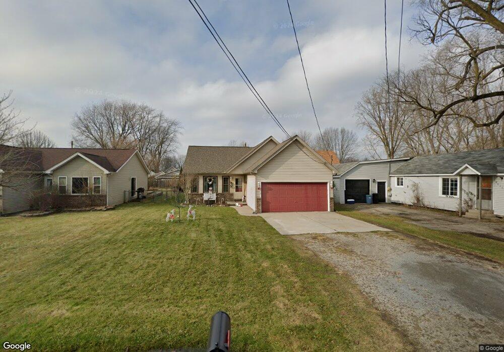
This home is located at 9618 Maynard Rd, Clay, MI 48001 and is currently estimated at $268,692, approximately $194 per square foot. 9618 Maynard Rd is a home located in St. Clair County.
Ownership History
Date
Name
Owned For
Owner Type
Purchase Details
Closed on
Nov 2, 2015
Sold by
Lents Mary A
Bought by
Lents Mary A and Lents Brian
Current Estimated Value
Home Financials for this Owner
Home Financials are based on the most recent Mortgage that was taken out on this home.
Original Mortgage
$106,990
Outstanding Balance
$83,570
Interest Rate
3.91%
Mortgage Type
New Conventional
Estimated Equity
$185,122
Purchase Details
Closed on
Jun 11, 2009
Sold by
Mitkus Matthew C and Bitten Janice
Bought by
Osentoski Mary Ann
Home Financials for this Owner
Home Financials are based on the most recent Mortgage that was taken out on this home.
Original Mortgage
$93,259
Interest Rate
4.86%
Mortgage Type
FHA
Purchase Details
Closed on
Jan 10, 2008
Sold by
Secretary Of Housing & Urban Development
Bought by
Mitkus Matthew C
Home Financials for this Owner
Home Financials are based on the most recent Mortgage that was taken out on this home.
Original Mortgage
$106,981
Interest Rate
6.13%
Mortgage Type
FHA
Purchase Details
Closed on
Jun 18, 2007
Sold by
Wells Fargo Bank Na
Bought by
The Secretary Of Housing & Urban Develop
Purchase Details
Closed on
Oct 26, 2006
Sold by
Robb Herbert J
Bought by
Wells Fargo Bank Na
Purchase Details
Closed on
Jan 28, 2005
Sold by
Vanover Michelle
Bought by
Robb Herbert J
Home Financials for this Owner
Home Financials are based on the most recent Mortgage that was taken out on this home.
Original Mortgage
$154,869
Interest Rate
5.83%
Mortgage Type
FHA
Create a Home Valuation Report for This Property
The Home Valuation Report is an in-depth analysis detailing your home's value as well as a comparison with similar homes in the area
Home Values in the Area
Average Home Value in this Area
Purchase History
| Date | Buyer | Sale Price | Title Company |
|---|---|---|---|
| Lents Mary A | $133 | -- | |
| Lents Mary A | $133 | -- | |
| Osentoski Mary Ann | $95,400 | None Available | |
| Mitkus Matthew C | $105,500 | None Available | |
| The Secretary Of Housing & Urban Develop | -- | None Available | |
| Wells Fargo Bank Na | $160,277 | None Available | |
| Robb Herbert J | $157,300 | None Available |
Source: Public Records
Mortgage History
| Date | Status | Borrower | Loan Amount |
|---|---|---|---|
| Open | Lents Mary A | $106,990 | |
| Closed | Lents Mary A | $106,990 | |
| Previous Owner | Osentoski Mary Ann | $93,259 | |
| Previous Owner | Mitkus Matthew C | $106,981 | |
| Previous Owner | Robb Herbert J | $154,869 |
Source: Public Records
Tax History
| Year | Tax Paid | Tax Assessment Tax Assessment Total Assessment is a certain percentage of the fair market value that is determined by local assessors to be the total taxable value of land and additions on the property. | Land | Improvement |
|---|---|---|---|---|
| 2025 | $1,074 | $113,800 | $0 | $0 |
| 2024 | $1,054 | $110,600 | $0 | $0 |
| 2023 | $1,016 | $98,200 | $0 | $0 |
| 2022 | $1,807 | $90,600 | $0 | $0 |
| 2020 | $1,699 | $79,100 | $79,100 | $0 |
| 2019 | $1,674 | $74,400 | $0 | $0 |
| 2018 | $1,647 | $58,400 | $0 | $0 |
| 2017 | $1,514 | $48,100 | $0 | $0 |
| 2016 | $834 | $48,100 | $0 | $0 |
| 2015 | -- | $46,400 | $46,400 | $0 |
| 2014 | -- | $43,000 | $43,000 | $0 |
| 2013 | -- | $42,400 | $0 | $0 |
Source: Public Records
Map
Nearby Homes
- 9996 Tashmoo Ln Unit 2
- 9994 Tashmoo Ln Unit 3
- 9643 Anchor Dr Unit 88
- 9636 Anchor Dr Unit 99
- 9658 Seaway Dr Unit 91
- 9634 Seaway Dr Unit 38
- 9761 Marina Cir Unit 292
- 5966 Starboard Ct Unit 284
- 9238 Harbor Ln Unit 288
- 7520 Colony Dr
- 0000 Taft Rd
- 00 Taft Rd
- 7208 Bluebill St
- 24 Vacant Lots Land
- 7261 Bluebill St
- 9665 River St
- 9084 Island Dr
- 7277 Cardinal St
- 2039 Golf Course Rd
- 7292 Bluebill Rd
- 9616 Maynard Rd
- 9620 Maynard Rd
- 9634 Maynard Rd
- 9636 Maynard Rd
- 9615 Pearl Beach Blvd
- 9612 Maynard Rd
- 9615 Maynard Rd
- 9635 Pearl Beach Blvd
- 9611 Maynard Rd
- 9635 Maynard Rd
- 9643 Pearl Beach Blvd
- 9637 Maynard Rd
- 9637 Maynard Rd
- 0 Maynard Ct Unit 215044642
- 0 Maynard Ct Unit 216112329
- 0 Maynard Ct Unit 217098379
- 0 Maynard Ct Unit 215130964
- 0 Maynard Ct Unit 4382457
- 0 Maynard Ct Unit 4374499
- 0 Maynard Ct Unit 4523848
Your Personal Tour Guide
Ask me questions while you tour the home.