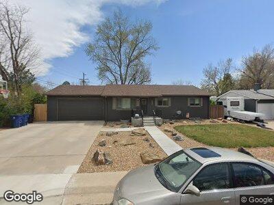
9640 Tyler Dr Arvada, CO 80004
Alta Vista NeighborhoodEstimated Value: $552,000 - $606,000
4
Beds
2
Baths
1,146
Sq Ft
$506/Sq Ft
Est. Value
About This Home
This home is located at 9640 Tyler Dr, Arvada, CO 80004 and is currently estimated at $579,887, approximately $506 per square foot. 9640 Tyler Dr is a home located in Jefferson County with nearby schools including Arvada K-8, Arvada High School, and Lincoln Charter Academy.
Ownership History
Date
Name
Owned For
Owner Type
Purchase Details
Closed on
Oct 9, 2022
Sold by
Scotty Kaleb B
Bought by
Scotty Kaleb B and Scotty Brittany S
Current Estimated Value
Purchase Details
Closed on
Jun 10, 2018
Sold by
Scotty Kaleb B
Bought by
Scotty Kaleb B and Scotty Brittany S
Purchase Details
Closed on
Nov 1, 2012
Sold by
Zakrzewski Marjean M
Bought by
Scotty Kaleb B
Home Financials for this Owner
Home Financials are based on the most recent Mortgage that was taken out on this home.
Original Mortgage
$177,525
Interest Rate
3.4%
Mortgage Type
New Conventional
Create a Home Valuation Report for This Property
The Home Valuation Report is an in-depth analysis detailing your home's value as well as a comparison with similar homes in the area
Home Values in the Area
Average Home Value in this Area
Purchase History
| Date | Buyer | Sale Price | Title Company |
|---|---|---|---|
| Scotty Kaleb B | $130,000 | -- | |
| Scotty Kaleb B | -- | None Available | |
| Scotty Kaleb B | $197,250 | Chicago Title Co |
Source: Public Records
Mortgage History
| Date | Status | Borrower | Loan Amount |
|---|---|---|---|
| Previous Owner | Scotty Kaleb B | $177,525 |
Source: Public Records
Tax History Compared to Growth
Tax History
| Year | Tax Paid | Tax Assessment Tax Assessment Total Assessment is a certain percentage of the fair market value that is determined by local assessors to be the total taxable value of land and additions on the property. | Land | Improvement |
|---|---|---|---|---|
| 2024 | $3,260 | $33,607 | $16,860 | $16,747 |
| 2023 | $3,260 | $33,607 | $16,860 | $16,747 |
| 2022 | $2,679 | $27,356 | $12,321 | $15,035 |
| 2021 | $2,723 | $28,144 | $12,676 | $15,468 |
| 2020 | $2,271 | $23,530 | $10,694 | $12,836 |
| 2019 | $2,240 | $23,530 | $10,694 | $12,836 |
| 2018 | $2,132 | $21,770 | $6,366 | $15,404 |
| 2017 | $1,951 | $21,770 | $6,366 | $15,404 |
| 2016 | $1,685 | $17,710 | $5,539 | $12,171 |
| 2015 | $1,452 | $17,710 | $5,539 | $12,171 |
| 2014 | $1,452 | $14,344 | $4,872 | $9,472 |
Source: Public Records
Map
Nearby Homes
- 6402 Iris Ct
- 6410 Independence Way
- 6359 Brooks Dr
- 6580 Independence Way
- 6314 Brooks Dr
- 6506 Lee St
- 6335 Oberon Rd
- 6613 Independence St
- 6373 Johnson Way
- 9743 W 67th Place
- 6717 Lee St
- 6025 Johnson Way
- 6737 Lee St
- 10550 W 63rd Ave
- 9105 Oberon Rd Unit 2
- 6757 Lee St
- 10560 W 63rd Ave
- 6190 Garrison St
- 10109 W 68th Ave
- 6068 Lee St
- 9640 Tyler Dr
- 6445 Independence Way
- 9650 Tyler Dr
- 9641 Shannon Dr
- 9651 Shannon Dr
- 6435 Independence Way
- 9645 Tyler Dr
- 9670 Tyler Dr
- 9655 Tyler Dr
- 6455 Independence Way
- 9661 Shannon Dr
- 9695 Tyler Dr
- 6412 Iris Ct
- 9671 Shannon Dr
- 9648 Shannon Dr
- 6463 Independence Way
- 6454 Independence Way
- 6424 Iris Ct
- 9658 Shannon Dr
- 6415 Independence Way