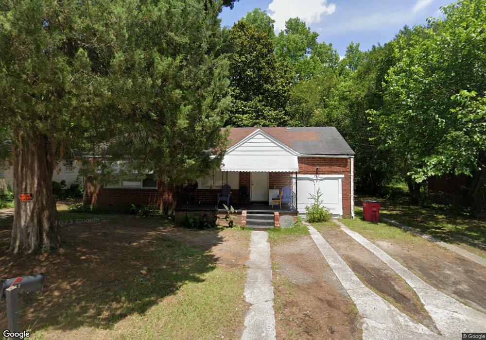
967 Sunnydale Dr Macon, GA 31217
Estimated Value: $64,000 - $81,000
2
Beds
1
Bath
962
Sq Ft
$76/Sq Ft
Est. Value
About This Home
This home is located at 967 Sunnydale Dr, Macon, GA 31217 and is currently estimated at $73,142, approximately $76 per square foot. 967 Sunnydale Dr is a home located in Bibb County with nearby schools including Martin Luther King Jr. Elementary School, Appling Middle School, and Northeast High School.
Ownership History
Date
Name
Owned For
Owner Type
Purchase Details
Closed on
Mar 9, 2017
Sold by
Grant Eyon
Bought by
Pettigrew Artice
Current Estimated Value
Purchase Details
Closed on
Feb 28, 2006
Sold by
Household Realty Corp
Bought by
Musehamp Cargill
Purchase Details
Closed on
Feb 27, 2006
Purchase Details
Closed on
Jan 3, 2006
Purchase Details
Closed on
Aug 29, 2005
Purchase Details
Closed on
Feb 1, 2005
Purchase Details
Closed on
Apr 23, 2004
Purchase Details
Closed on
Feb 28, 2003
Create a Home Valuation Report for This Property
The Home Valuation Report is an in-depth analysis detailing your home's value as well as a comparison with similar homes in the area
Home Values in the Area
Average Home Value in this Area
Purchase History
| Date | Buyer | Sale Price | Title Company |
|---|---|---|---|
| Pettigrew Artice | -- | -- | |
| Musehamp Cargill | $14,900 | None Avilebel | |
| -- | $57,000 | -- | |
| -- | $21,600 | -- | |
| -- | $9,000 | -- | |
| -- | $41,500 | -- | |
| -- | $55,000 | -- | |
| -- | $42,800 | -- |
Source: Public Records
Tax History Compared to Growth
Tax History
| Year | Tax Paid | Tax Assessment Tax Assessment Total Assessment is a certain percentage of the fair market value that is determined by local assessors to be the total taxable value of land and additions on the property. | Land | Improvement |
|---|---|---|---|---|
| 2025 | $615 | $25,037 | $2,025 | $23,012 |
| 2024 | $636 | $25,037 | $2,025 | $23,012 |
| 2023 | $639 | $21,585 | $2,025 | $19,560 |
| 2022 | $453 | $13,072 | $2,419 | $10,653 |
| 2021 | $335 | $8,819 | $1,210 | $7,609 |
| 2020 | $313 | $8,058 | $1,210 | $6,848 |
| 2019 | $340 | $8,684 | $1,075 | $7,609 |
| 2018 | $701 | $8,684 | $1,075 | $7,609 |
| 2017 | $323 | $8,624 | $1,075 | $7,549 |
| 2016 | $298 | $8,624 | $1,075 | $7,549 |
| 2015 | $422 | $8,624 | $1,075 | $7,549 |
| 2014 | $486 | $8,624 | $1,075 | $7,549 |
Source: Public Records
Map
Nearby Homes
- 1008 Sunnydale Dr
- 1030 Forsyth Ave
- 909 Johnson St
- 710 Magnolia Dr
- 1213 Eastview Ave
- 837 Artic Cir
- 875 Artic Place
- 684 Reese St
- 1209 Eastview Ave
- 769 Bowman St
- 4436 Jeffersonville Rd
- 1818 Kinder Kare Dr
- 747 Bowman St
- 875 Artic Cir
- 1840 Kinder Kare Dr
- 1024 Clarks Ln
- 2066 Melton Ave
- 1012 Emery Hwy
- 2146 Melton Ave
- 845 Norris St
- 951 Sunnydale Dr
- 995 Sunnydale Dr
- 960 Sunnydale Dr
- 972 Sunnydale Dr
- 923 Sunnydale Dr
- 1009 Sunnydale Dr
- 990 Sunnydale Dr
- 946 Sunnydale Dr
- 0 Sunnydale Dr Unit 7013531
- 0 Sunnydale Dr Unit 3274470
- 0 Sunnydale Dr Unit 3125194
- 0 Sunnydale Dr
- 930 Sunnydale Dr
- 1021 Sunnydale Dr
- 1042 Sparkle Ave
- 907 Sunnydale Dr
- 912 Sunnydale Dr
- 955 Dorothy St
- 1034 Sparkle Ave
- 1035 Sunnydale Dr