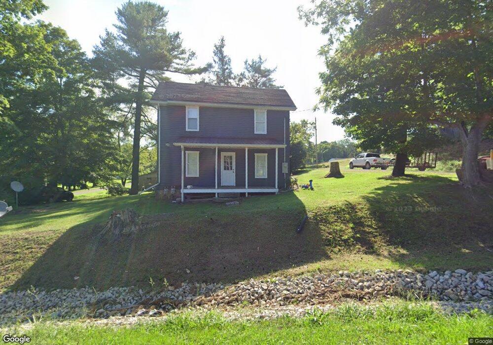
9680 State Route 555 Cutler, OH 45724
Estimated Value: $117,156 - $299,000
4
Beds
1
Bath
1,404
Sq Ft
$130/Sq Ft
Est. Value
About This Home
This home is located at 9680 State Route 555, Cutler, OH 45724 and is currently estimated at $182,039, approximately $129 per square foot. 9680 State Route 555 is a home with nearby schools including Warren High School.
Ownership History
Date
Name
Owned For
Owner Type
Purchase Details
Closed on
Aug 8, 2018
Bought by
Smith Ashley L
Current Estimated Value
Home Financials for this Owner
Home Financials are based on the most recent Mortgage that was taken out on this home.
Interest Rate
4.6%
Purchase Details
Closed on
Jul 6, 2007
Sold by
Crabtree Raymond E and Crabtree Dorothy L
Bought by
Crabtree Raymond E and Crabtree Dorothy L
Purchase Details
Closed on
Dec 9, 1988
Bought by
Remely Gale R and Remely Crabtree
Create a Home Valuation Report for This Property
The Home Valuation Report is an in-depth analysis detailing your home's value as well as a comparison with similar homes in the area
Home Values in the Area
Average Home Value in this Area
Purchase History
| Date | Buyer | Sale Price | Title Company |
|---|---|---|---|
| Smith Ashley L | $16,000 | -- | |
| Crabtree Raymond E | -- | None Available | |
| Crabtree Raymond E | -- | None Available | |
| Remely Gale R | -- | -- | |
| Remely Gale R | -- | -- |
Source: Public Records
Mortgage History
| Date | Status | Borrower | Loan Amount |
|---|---|---|---|
| Closed | Smith Ashley L | -- |
Source: Public Records
Tax History Compared to Growth
Tax History
| Year | Tax Paid | Tax Assessment Tax Assessment Total Assessment is a certain percentage of the fair market value that is determined by local assessors to be the total taxable value of land and additions on the property. | Land | Improvement |
|---|---|---|---|---|
| 2024 | $993 | $26,680 | $900 | $25,780 |
| 2023 | $993 | $26,680 | $900 | $25,780 |
| 2022 | $989 | $26,680 | $900 | $25,780 |
| 2021 | $1,297 | $33,550 | $1,630 | $31,920 |
| 2020 | $1,295 | $33,550 | $1,630 | $31,920 |
| 2019 | $401 | $10,530 | $1,630 | $8,900 |
| 2018 | $423 | $10,530 | $1,630 | $8,900 |
| 2017 | $420 | $10,530 | $1,630 | $8,900 |
| 2016 | $367 | $10,530 | $1,630 | $8,900 |
| 2015 | $341 | $9,530 | $2,020 | $7,510 |
| 2014 | $476 | $9,530 | $2,020 | $7,510 |
| 2013 | $334 | $9,530 | $2,020 | $7,510 |
Source: Public Records
Map
Nearby Homes
- 849 Clark Rd
- 2500 Robert Kelly Rd
- 852 Wallace Rd
- 22775 Mayle Ridge Rd
- 2207 Veto Rd
- 28 Mcgill Rd
- 2567 State Route 555
- 6750 O'Neil Rd
- 1556 Mcgill Rd
- State Route 329
- 1015 Brackenridge Rd
- 6104 Boyer Rd
- 631 Short Brook Rd
- 0 T1309
- 0 Layman Rd Unit 5162075
- 0 Layman Rd Unit 5162072
- 5595 N Torch Rd
- 120 Fleming Dr
- 735 Timberline Dr
- 171 Veto Cir
- 124 Bank St
- 3536 Big Run Rd
- 9626 State Route 555
- 100 Bank St
- 0 T1061
- 9602 State Route 555
- 10 Hanover Rd
- 72 Mcatee St
- 30 Hanover Rd
- 88 Mcatee St
- 40 Hanover Rd
- 70 Hanover Rd
- 3508 Big Run Rd
- 9834 State Route 555
- 9829 State Route 555
- 9829 State Route 555
- 9829 State Route 555
- 9829 State Route 555
- 9829 State Route 555
- 9829 State Route 555