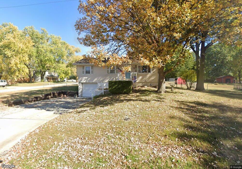
97 Kirkland Ave Liberty, MO 64068
Estimated Value: $206,000 - $259,000
3
Beds
--
Bath
912
Sq Ft
$261/Sq Ft
Est. Value
About This Home
This home is located at 97 Kirkland Ave, Liberty, MO 64068 and is currently estimated at $237,850, approximately $260 per square foot. 97 Kirkland Ave is a home located in Clay County with nearby schools including Alexander Doniphan Elementary School, Discovery Middle School, and Liberty High School.
Ownership History
Date
Name
Owned For
Owner Type
Purchase Details
Closed on
Jul 7, 2003
Sold by
Davis Christine R
Bought by
Davis James Thomas and Davis Grant Justin
Current Estimated Value
Purchase Details
Closed on
May 28, 2002
Sold by
Jackson Kent D and Jackson Deanna A
Bought by
Davis Christine R
Home Financials for this Owner
Home Financials are based on the most recent Mortgage that was taken out on this home.
Original Mortgage
$103,377
Outstanding Balance
$44,050
Interest Rate
6.92%
Mortgage Type
FHA
Estimated Equity
$193,800
Create a Home Valuation Report for This Property
The Home Valuation Report is an in-depth analysis detailing your home's value as well as a comparison with similar homes in the area
Home Values in the Area
Average Home Value in this Area
Purchase History
| Date | Buyer | Sale Price | Title Company |
|---|---|---|---|
| Davis James Thomas | -- | -- | |
| Davis Christine R | -- | United Title Company Inc |
Source: Public Records
Mortgage History
| Date | Status | Borrower | Loan Amount |
|---|---|---|---|
| Open | Davis Christine R | $103,377 |
Source: Public Records
Tax History Compared to Growth
Tax History
| Year | Tax Paid | Tax Assessment Tax Assessment Total Assessment is a certain percentage of the fair market value that is determined by local assessors to be the total taxable value of land and additions on the property. | Land | Improvement |
|---|---|---|---|---|
| 2025 | $1,522 | $23,330 | -- | -- |
| 2024 | $1,522 | $20,620 | -- | -- |
| 2023 | $1,545 | $20,620 | $0 | $0 |
| 2022 | $1,425 | $18,810 | $0 | $0 |
| 2021 | $1,431 | $18,810 | $5,510 | $13,300 |
| 2020 | $1,544 | $19,150 | $0 | $0 |
| 2019 | $1,545 | $19,152 | $6,650 | $12,502 |
| 2018 | $1,273 | $15,490 | $0 | $0 |
| 2017 | $1,259 | $15,480 | $3,420 | $12,060 |
| 2016 | $1,259 | $15,480 | $3,420 | $12,060 |
| 2015 | $1,259 | $15,480 | $3,420 | $12,060 |
| 2014 | $1,262 | $15,480 | $3,420 | $12,060 |
Source: Public Records
Map
Nearby Homes
- 1733 Welleslay Ln
- 1537 Canterbury Ln
- 1507 Amesbury Ave
- 1323 Amesbury Ave
- 1327 Easton Ct
- 1205 Blackberry Dr
- 1218 Canterbury Ln
- 1304 Wellington Way
- 1836 Green Meadow Dr
- 1856 Arbor Trail
- 2188 Heritage Ct
- 1845 Arbor Trail
- McKinley Plan at Homestead of Liberty - Homestead
- Monroe Plan at Homestead of Liberty - Homestead
- Chestnut Plan at Homestead of Liberty - Homestead
- The Brooklyn Plan at Homestead of Liberty - Homestead
- Cypress Plan at Homestead of Liberty - Homestead
- The Linden Plan at Homestead of Liberty - Homestead
- Spruce Plan at Homestead of Liberty - Homestead
- Ashton Plan at Homestead of Liberty - Homestead
- 401 Wherritt Ln
- 103 Kirkland Ave
- 102 Kirkland Ave
- 403 Wherritt Ln
- 402 Wherritt Ln
- 200 Kirkland Ave
- 105 Kirkland Ave
- 104 Kirkland Ave
- 405 Wherritt Ln
- 106 Kirkland Ave
- 404 Wherritt Ln
- 1709 S Wales
- 202 Kirkland Ave
- 1608 Canterbury Ct
- 1705 S Wales
- 400 Smiley Rd
- 318 Smiley Rd
- 1713 S Wales
- 407 Wherritt Ln
- 1604 Canterbury Ct