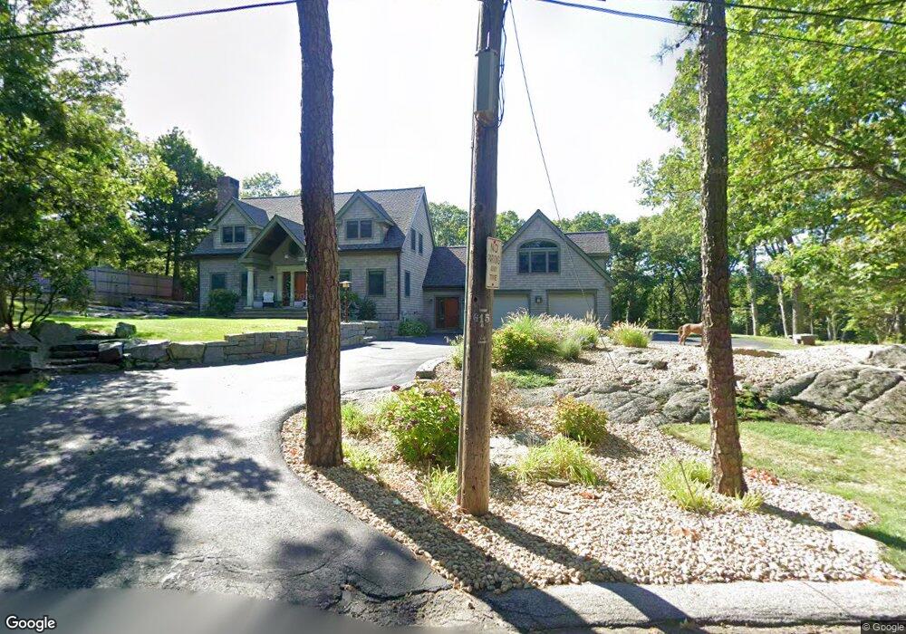
97 Phillips Ave Rockport, MA 01966
Estimated Value: $1,736,169 - $1,991,000
3
Beds
3
Baths
3,546
Sq Ft
$514/Sq Ft
Est. Value
About This Home
This home is located at 97 Phillips Ave, Rockport, MA 01966 and is currently estimated at $1,822,042, approximately $513 per square foot. 97 Phillips Ave is a home located in Essex County with nearby schools including Rockport Elementary School, Rockport Middle School, and Rockport High School.
Ownership History
Date
Name
Owned For
Owner Type
Purchase Details
Closed on
Jul 24, 2024
Sold by
Gilbert Linda C
Bought by
Lcg Rt and Gilbert
Current Estimated Value
Purchase Details
Closed on
May 17, 2021
Sold by
Ss Rt and Foster
Bought by
Gilbert Linda C and Walkinshaw Steven M
Purchase Details
Closed on
Sep 11, 1998
Sold by
Vogelstein Henry J and Vogelstein Susan B
Bought by
Ss Rt
Create a Home Valuation Report for This Property
The Home Valuation Report is an in-depth analysis detailing your home's value as well as a comparison with similar homes in the area
Home Values in the Area
Average Home Value in this Area
Purchase History
| Date | Buyer | Sale Price | Title Company |
|---|---|---|---|
| Lcg Rt | -- | None Available | |
| Lcg Rt | -- | None Available | |
| Lcg Rt | -- | None Available | |
| Gilbert Linda C | $1,350,000 | None Available | |
| Gilbert Linda C | $1,350,000 | None Available | |
| Gilbert Linda C | $1,350,000 | None Available | |
| Ss Rt | $140,000 | -- | |
| Ss Rt | $140,000 | -- |
Source: Public Records
Mortgage History
| Date | Status | Borrower | Loan Amount |
|---|---|---|---|
| Previous Owner | Ss Rt | $50,000 | |
| Previous Owner | Ss Rt | $103,000 | |
| Previous Owner | Ss Rt | $250,000 |
Source: Public Records
Tax History Compared to Growth
Tax History
| Year | Tax Paid | Tax Assessment Tax Assessment Total Assessment is a certain percentage of the fair market value that is determined by local assessors to be the total taxable value of land and additions on the property. | Land | Improvement |
|---|---|---|---|---|
| 2025 | $11,881 | $1,356,300 | $388,500 | $967,800 |
| 2024 | $11,420 | $1,356,300 | $388,500 | $967,800 |
| 2023 | $10,886 | $1,154,400 | $319,800 | $834,600 |
| 2022 | $9,644 | $982,100 | $320,900 | $661,200 |
| 2021 | $9,108 | $935,100 | $305,700 | $629,400 |
| 2020 | $9,947 | $984,900 | $291,100 | $693,800 |
| 2019 | $9,318 | $945,000 | $288,300 | $656,700 |
| 2018 | $9,598 | $949,400 | $267,700 | $681,700 |
| 2017 | $9,371 | $830,800 | $242,800 | $588,000 |
| 2016 | $9,188 | $816,700 | $236,000 | $580,700 |
| 2015 | $8,775 | $797,700 | $236,000 | $561,700 |
| 2014 | $8,534 | $757,200 | $217,800 | $539,400 |
Source: Public Records
Map
Nearby Homes
- 13 Phillips Ave
- 25 Stockholm Ave
- 165 Granite St
- 2 Wharf Rd
- 2 Boulder Top
- 13 Rowe Point
- 26 Quarry Ridge Ln
- 40 Quarry Ridge Ln
- 48 Rowley Shore
- 63R Main St Unit 2
- 11 Atlantic Ave
- 2 Mount Pleasant St Unit 3
- 6 Mount Locust Place Unit 2
- 15 High St Unit D
- 5 Allen Ave
- 4 Norwood Ave
- 962 Washington St
- 13 Pleasant St Unit 3
- 57 Mt Pleasant St Unit 2B
- 5 Marshall Ln
- 95 Phillips Ave
- 99 Phillips Ave
- 94 Phillips Ave
- 101 Phillips Ave
- 92 Phillips Ave
- 1 Andrews Hollow
- 93 Phillips Ave
- 90 Phillips Ave
- 105 Phillips Ave
- 89 Phillips Ave
- 3 Andrews Hollow
- 88 Phillips Ave
- 0 Thornwood Ave
- 87 Phillips Ave
- 107 Phillips Ave
- 5 Andrews Hollow
- 85 Phillips Ave
- 103 Phillips Ave
- 80 Phillips Ave
- 4 Andrews Hollow