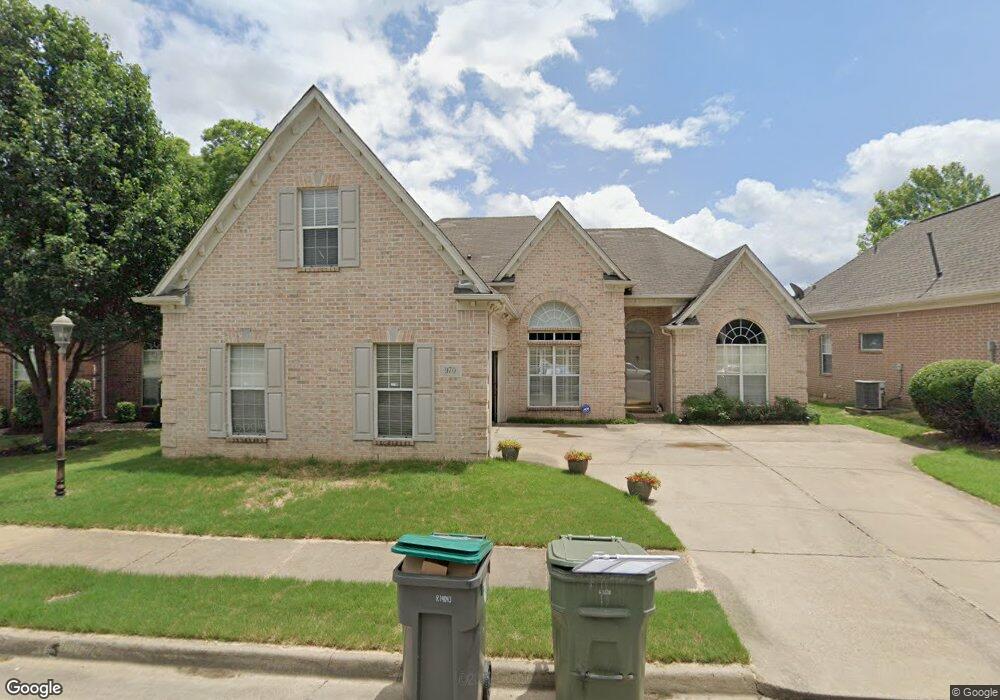
970 Nesting Wood Cir E Cordova, TN 38018
Cordova NeighborhoodEstimated Value: $289,000 - $302,000
4
Beds
2
Baths
2,249
Sq Ft
$130/Sq Ft
Est. Value
About This Home
This home is located at 970 Nesting Wood Cir E, Cordova, TN 38018 and is currently estimated at $293,365, approximately $130 per square foot. 970 Nesting Wood Cir E is a home located in Shelby County with nearby schools including Cordova Elementary School, Cordova Middle School, and Cordova High School.
Ownership History
Date
Name
Owned For
Owner Type
Purchase Details
Closed on
Sep 10, 2024
Sold by
Nason Eric
Bought by
Nason Eric and Nason Lucia Arteaga
Current Estimated Value
Purchase Details
Closed on
Jul 1, 2011
Sold by
Wright Wanda
Bought by
Nason Eric
Home Financials for this Owner
Home Financials are based on the most recent Mortgage that was taken out on this home.
Original Mortgage
$143,273
Interest Rate
4.49%
Mortgage Type
FHA
Purchase Details
Closed on
Mar 29, 2001
Sold by
Lenox Homes Llc
Bought by
Wright Wanda
Home Financials for this Owner
Home Financials are based on the most recent Mortgage that was taken out on this home.
Original Mortgage
$163,300
Interest Rate
7.11%
Create a Home Valuation Report for This Property
The Home Valuation Report is an in-depth analysis detailing your home's value as well as a comparison with similar homes in the area
Home Values in the Area
Average Home Value in this Area
Purchase History
| Date | Buyer | Sale Price | Title Company |
|---|---|---|---|
| Nason Eric | -- | None Listed On Document | |
| Nason Eric | $147,000 | Realty Title | |
| Wright Wanda | $171,935 | Southern Escrow Title Compan |
Source: Public Records
Mortgage History
| Date | Status | Borrower | Loan Amount |
|---|---|---|---|
| Previous Owner | Nason Eric | $143,273 | |
| Previous Owner | Wright Wanda | $163,300 |
Source: Public Records
Tax History Compared to Growth
Tax History
| Year | Tax Paid | Tax Assessment Tax Assessment Total Assessment is a certain percentage of the fair market value that is determined by local assessors to be the total taxable value of land and additions on the property. | Land | Improvement |
|---|---|---|---|---|
| 2025 | $1,690 | $73,725 | $13,500 | $60,225 |
| 2024 | $1,690 | $49,850 | $8,750 | $41,100 |
| 2023 | $3,037 | $49,850 | $8,750 | $41,100 |
| 2022 | $3,037 | $49,850 | $8,750 | $41,100 |
| 2021 | $3,072 | $49,850 | $8,750 | $41,100 |
| 2020 | $2,855 | $39,400 | $8,750 | $30,650 |
| 2019 | $2,855 | $39,400 | $8,750 | $30,650 |
| 2018 | $2,855 | $39,400 | $8,750 | $30,650 |
| 2017 | $1,619 | $39,400 | $8,750 | $30,650 |
| 2016 | $1,552 | $35,525 | $0 | $0 |
| 2014 | $1,552 | $35,525 | $0 | $0 |
Source: Public Records
Map
Nearby Homes
- 984 Nesting Wood Cir E
- 970 Cully Rd
- 8453 Thor Rd
- 970 Bending Pine Ln
- 8502 Griffin Park Dr
- 884 Camden Grove Cove
- 8520 Shady Elm Dr
- 1018 Cassabella Cove
- 8524 Shady Elm Dr
- 862 Cairn Creek Dr
- 857 Paradise Dr
- 1025 Belfiore Ln
- 8301 Weatherwood Ln
- 878 Timber Grove Dr
- 901 Timber Grove Dr
- 871 Sun Vista Dr E
- 736 Tealwood Ln
- 8495 Farley Ave
- 1235 Dexter Ln
- 8143 Timber Knoll Ln
- 966 Nesting Wood Cir E
- 976 Nesting Wood Cir E
- 969 Misty Birch Ln
- 965 Misty Birch Ln
- 971 Nesting Wood Cir E
- 967 Nesting Wood Cir E
- 959 Misty Birch Ln
- 979 Misty Birch Ln
- 952 Nesting Wood Cir E
- 961 Nesting Wood Cir E
- 990 Nesting Wood Cir E
- 951 Misty Birch Ln
- 953 Nesting Wood Cir E
- 8420 Aspen Meadow Dr
- 948 Nesting Wood Cir E
- 980 Nesting Wood Cir W
- 995 Nesting Wood Cir W
- 964 Misty Birch Ln
- 8425 Aspen Meadow Dr
- 964 Nesting Wood Cir W