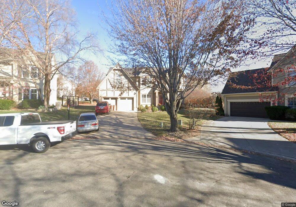
9704 W 132nd St Overland Park, KS 66213
Nottingham NeighborhoodEstimated Value: $508,000 - $548,000
4
Beds
3
Baths
2,538
Sq Ft
$210/Sq Ft
Est. Value
About This Home
This home is located at 9704 W 132nd St, Overland Park, KS 66213 and is currently estimated at $533,855, approximately $210 per square foot. 9704 W 132nd St is a home located in Johnson County with nearby schools including Cottonwood Point Elementary School, Oxford Middle, and Blue Valley Northwest High School.
Ownership History
Date
Name
Owned For
Owner Type
Purchase Details
Closed on
Mar 19, 2002
Sold by
Smith Maryann and The Maryann Smith Trust
Bought by
Easum Michael R and Easum Elizabeth C
Current Estimated Value
Home Financials for this Owner
Home Financials are based on the most recent Mortgage that was taken out on this home.
Original Mortgage
$140,000
Outstanding Balance
$57,699
Interest Rate
6.87%
Estimated Equity
$476,156
Purchase Details
Closed on
Apr 26, 2001
Sold by
Smith Maryann and The Maryann Smith Trust
Bought by
Smith Maryann
Home Financials for this Owner
Home Financials are based on the most recent Mortgage that was taken out on this home.
Original Mortgage
$113,500
Interest Rate
6.81%
Create a Home Valuation Report for This Property
The Home Valuation Report is an in-depth analysis detailing your home's value as well as a comparison with similar homes in the area
Home Values in the Area
Average Home Value in this Area
Purchase History
| Date | Buyer | Sale Price | Title Company |
|---|---|---|---|
| Easum Michael R | $215,000 | Stewart Title | |
| Smith Maryann | -- | Stewart Title |
Source: Public Records
Mortgage History
| Date | Status | Borrower | Loan Amount |
|---|---|---|---|
| Open | Easum Michael R | $140,000 | |
| Previous Owner | Smith Maryann | $113,500 |
Source: Public Records
Tax History Compared to Growth
Tax History
| Year | Tax Paid | Tax Assessment Tax Assessment Total Assessment is a certain percentage of the fair market value that is determined by local assessors to be the total taxable value of land and additions on the property. | Land | Improvement |
|---|---|---|---|---|
| 2024 | $5,625 | $54,958 | $11,555 | $43,403 |
| 2023 | $5,476 | $52,589 | $11,555 | $41,034 |
| 2022 | $4,987 | $47,058 | $11,555 | $35,503 |
| 2021 | $4,692 | $42,009 | $10,052 | $31,957 |
| 2020 | $4,679 | $41,607 | $8,375 | $33,232 |
| 2019 | $4,484 | $39,031 | $6,699 | $32,332 |
| 2018 | $4,429 | $37,789 | $6,699 | $31,090 |
| 2017 | $4,175 | $35,006 | $5,828 | $29,178 |
| 2016 | $3,861 | $32,349 | $5,828 | $26,521 |
| 2015 | $3,756 | $31,349 | $5,828 | $25,521 |
| 2013 | -- | $29,267 | $5,828 | $23,439 |
Source: Public Records
Map
Nearby Homes
- 13164 Connell Dr
- 9608 W 132nd Terrace
- 9139 W 131st Place
- 13163 Kessler St
- 12907 Connell Dr
- 12823 Connell Dr
- 12906 Wedd St
- 13010 Stearns St
- 10600 W 101st Terrace
- 13416 W 178th St
- 13408 W 178th St
- 13119 Hadley St
- 9117 W 125th Terrace
- 13808 Hayes St
- 8957 W 125th Terrace
- 12553 Grandview St
- 8130 W 131st Ct
- 8121 W 130th St
- 9019 W 139th Terrace
- 8812 W 124th Terrace
- 9700 W 132nd St
- 9708 W 132nd St
- 13169 Knox St
- 13180 Carter St
- 13176 Carter St
- 13170 Knox St
- 9712 W 132nd St
- 13165 Knox St
- 9701 W 132nd St
- 13184 Carter St
- 13172 Carter St
- 9716 W 132nd St
- 9705 W 132nd St
- 13166 Knox St
- 9709 W 132nd St
- 13188 Carter St
- 13168 Carter St
- 13161 Knox St
- 9713 W 132nd St
- 13200 Carter St