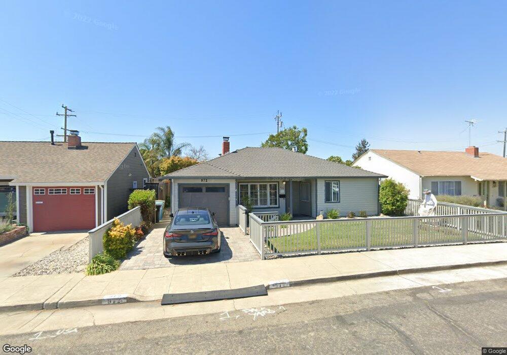
972 Daisy St San Mateo, CA 94401
South Shoreview NeighborhoodEstimated Value: $1,479,000 - $1,631,000
3
Beds
2
Baths
1,790
Sq Ft
$867/Sq Ft
Est. Value
About This Home
This home is located at 972 Daisy St, San Mateo, CA 94401 and is currently estimated at $1,551,129, approximately $866 per square foot. 972 Daisy St is a home located in San Mateo County with nearby schools including Lead Elementary School, Bayside Academy, and Aragon High School.
Ownership History
Date
Name
Owned For
Owner Type
Purchase Details
Closed on
Aug 27, 2012
Sold by
Gilbert Anthony B
Bought by
Gilbert Anthony
Current Estimated Value
Purchase Details
Closed on
Dec 22, 2010
Sold by
Gilbert Anthony B and Seth Evelyn
Bought by
Gilbert Anthony B
Home Financials for this Owner
Home Financials are based on the most recent Mortgage that was taken out on this home.
Original Mortgage
$368,000
Outstanding Balance
$250,444
Interest Rate
4.82%
Mortgage Type
New Conventional
Estimated Equity
$1,300,685
Purchase Details
Closed on
Jan 26, 2004
Sold by
Gilbert Anthony B and Seth Evelyn
Bought by
Gilbert Anthony and Seth Evelyn
Purchase Details
Closed on
Jun 20, 1995
Sold by
Gilbert Norma
Bought by
Gilbert Anthony B and Seth Evelyn
Home Financials for this Owner
Home Financials are based on the most recent Mortgage that was taken out on this home.
Original Mortgage
$195,000
Interest Rate
7.88%
Create a Home Valuation Report for This Property
The Home Valuation Report is an in-depth analysis detailing your home's value as well as a comparison with similar homes in the area
Home Values in the Area
Average Home Value in this Area
Purchase History
| Date | Buyer | Sale Price | Title Company |
|---|---|---|---|
| Gilbert Anthony | -- | None Available | |
| Gilbert Anthony B | -- | North American Title Company | |
| Gilbert Anthony | -- | -- | |
| Gilbert Anthony B | $115,000 | North American Title Company |
Source: Public Records
Mortgage History
| Date | Status | Borrower | Loan Amount |
|---|---|---|---|
| Open | Gilbert Anthony B | $368,000 | |
| Closed | Gilbert Anthony B | $195,000 |
Source: Public Records
Tax History Compared to Growth
Tax History
| Year | Tax Paid | Tax Assessment Tax Assessment Total Assessment is a certain percentage of the fair market value that is determined by local assessors to be the total taxable value of land and additions on the property. | Land | Improvement |
|---|---|---|---|---|
| 2025 | $5,747 | $288,333 | $104,469 | $183,864 |
| 2023 | $5,747 | $277,138 | $100,413 | $176,725 |
| 2022 | $4,560 | $271,705 | $98,445 | $173,260 |
| 2021 | $4,619 | $266,378 | $96,515 | $169,863 |
| 2020 | $5,328 | $263,648 | $95,526 | $168,122 |
| 2019 | $5,230 | $258,479 | $93,653 | $164,826 |
| 2018 | $3,728 | $253,412 | $91,817 | $161,595 |
| 2017 | $4,496 | $248,444 | $90,017 | $158,427 |
| 2016 | $3,940 | $243,573 | $88,252 | $155,321 |
| 2015 | $3,932 | $239,915 | $86,927 | $152,988 |
| 2014 | $3,571 | $235,217 | $85,225 | $149,992 |
Source: Public Records
Map
Nearby Homes
- 2141 Meadow View Place
- 1224 Norton St
- 808 Patricia Ave
- 104 N Hummingbird Ln
- 1201 S Hummingbird Ln
- 1225 Carlisle Dr
- 1401 Cary Ave
- 220 Waters Park Cir Unit 201
- 600 Patricia Ave
- 401 S Norfolk St Unit 123
- 425 Anchor Rd Unit 317
- 1662 Washington St
- 209 Ryder St
- 1117 Shoal Dr
- 1761 Lake St
- 220 Lindbergh St
- 1757 S Norfolk St Unit S
- 724 10th Ave
- 1663 Wolfe Dr
- 2241 Armada Way