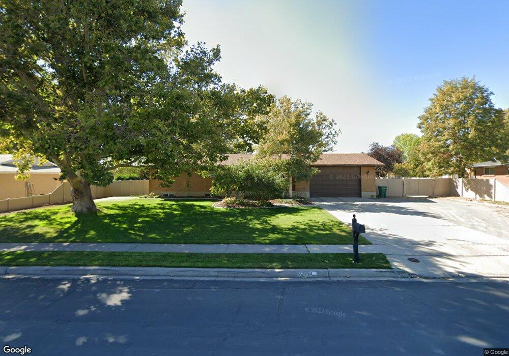
9747 N 6530 W Highland, UT 84003
Estimated Value: $816,000 - $1,013,000
4
Beds
3
Baths
2,470
Sq Ft
$369/Sq Ft
Est. Value
About This Home
This home is located at 9747 N 6530 W, Highland, UT 84003 and is currently estimated at $910,538, approximately $368 per square foot. 9747 N 6530 W is a home located in Utah County with nearby schools including Freedom Elementary School, Mountain Ridge Junior High School, and American Fork High School.
Ownership History
Date
Name
Owned For
Owner Type
Purchase Details
Closed on
Jun 20, 2014
Sold by
Later David N and Stephens Karen
Bought by
Miner Scott Larry and Miner Colette R
Current Estimated Value
Home Financials for this Owner
Home Financials are based on the most recent Mortgage that was taken out on this home.
Original Mortgage
$405,000
Outstanding Balance
$307,704
Interest Rate
4.17%
Mortgage Type
Construction
Estimated Equity
$602,834
Purchase Details
Closed on
Aug 30, 2007
Sold by
Later Vera N
Bought by
Later Vera N and Vera N Later Trust
Purchase Details
Closed on
Dec 15, 1998
Sold by
Mabe Brad L and Mabe Ellen M
Bought by
Later Wendell C and Later Vera N
Home Financials for this Owner
Home Financials are based on the most recent Mortgage that was taken out on this home.
Original Mortgage
$123,400
Interest Rate
6.86%
Create a Home Valuation Report for This Property
The Home Valuation Report is an in-depth analysis detailing your home's value as well as a comparison with similar homes in the area
Home Values in the Area
Average Home Value in this Area
Purchase History
| Date | Buyer | Sale Price | Title Company |
|---|---|---|---|
| Miner Scott Larry | -- | Affiliated First Title Co | |
| Later Vera N | -- | None Available | |
| Later Wendell C | -- | Associated Title Company |
Source: Public Records
Mortgage History
| Date | Status | Borrower | Loan Amount |
|---|---|---|---|
| Open | Miner Scott Larry | $405,000 | |
| Previous Owner | Later Wendell C | $123,400 |
Source: Public Records
Tax History Compared to Growth
Tax History
| Year | Tax Paid | Tax Assessment Tax Assessment Total Assessment is a certain percentage of the fair market value that is determined by local assessors to be the total taxable value of land and additions on the property. | Land | Improvement |
|---|---|---|---|---|
| 2025 | $3,378 | $428,180 | $426,200 | $343,800 |
| 2024 | $3,378 | $417,230 | $0 | $0 |
| 2023 | $3,184 | $424,195 | $0 | $0 |
| 2022 | $3,146 | $731,400 | $386,700 | $344,700 |
| 2021 | $2,677 | $510,600 | $241,300 | $269,300 |
| 2020 | $2,504 | $468,700 | $209,800 | $258,900 |
| 2019 | $2,223 | $434,900 | $209,800 | $225,100 |
| 2018 | $2,102 | $390,500 | $194,800 | $195,700 |
| 2017 | $1,853 | $185,610 | $0 | $0 |
| 2016 | $1,784 | $166,955 | $0 | $0 |
| 2015 | $1,728 | $153,315 | $0 | $0 |
| 2014 | $1,505 | $132,350 | $0 | $0 |
Source: Public Records
Map
Nearby Homes
- 6692 W 9770 N
- 9924 N 6630 W Unit 9
- 9967 N 6670 W
- 1438 N 400 W
- 6399 W 10150 N
- 9435 N Aspen Hollow Cir
- 356 W 1300 N
- 6190 W 10050 N
- 287 W 1360 N
- 9780 N 6000 W
- 425 W 1120 N
- 179 W 1290 N
- 5973 W 9960 N
- 344 W 1080 N
- 471 W 1040 N
- 6372 W 10400 N
- 10434 N 6400 W
- 3935 W 1000 N Unit 438
- 3983 W 1000 N Unit 442
- 4007 W 1000 N