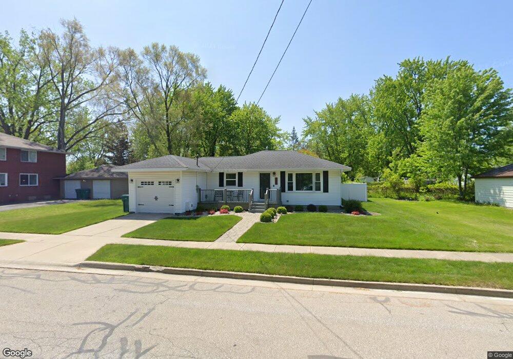
975 Kern St Auburn, MI 48611
Estimated Value: $131,000 - $149,000
2
Beds
1
Bath
875
Sq Ft
$158/Sq Ft
Est. Value
About This Home
This home is located at 975 Kern St, Auburn, MI 48611 and is currently estimated at $138,152, approximately $157 per square foot. 975 Kern St is a home located in Bay County with nearby schools including Thrasher Attendance Center, Auburn Elementary School, and Western Middle School.
Ownership History
Date
Name
Owned For
Owner Type
Purchase Details
Closed on
Oct 31, 2025
Sold by
Szeliga Crystal L and Horneber David A
Bought by
Szeliga Crystal L
Current Estimated Value
Home Financials for this Owner
Home Financials are based on the most recent Mortgage that was taken out on this home.
Original Mortgage
$37,600
Outstanding Balance
$37,600
Interest Rate
6.3%
Mortgage Type
New Conventional
Estimated Equity
$100,552
Purchase Details
Closed on
Nov 24, 2010
Sold by
Herron Shirley J and Medford Nancy L
Bought by
Szeliga Crystal L and Horneber David A
Home Financials for this Owner
Home Financials are based on the most recent Mortgage that was taken out on this home.
Original Mortgage
$57,570
Interest Rate
4.17%
Mortgage Type
FHA
Purchase Details
Closed on
Apr 6, 2006
Sold by
Lefevre Adeline B
Bought by
Lefevre Adeline B and Herron Shirley J
Purchase Details
Closed on
Apr 5, 2006
Sold by
Lefevre Adeline B
Bought by
Lefevre Adeline B
Create a Home Valuation Report for This Property
The Home Valuation Report is an in-depth analysis detailing your home's value as well as a comparison with similar homes in the area
Home Values in the Area
Average Home Value in this Area
Purchase History
| Date | Buyer | Sale Price | Title Company |
|---|---|---|---|
| Szeliga Crystal L | -- | None Listed On Document | |
| Szeliga Crystal L | $60,000 | None Available | |
| Lefevre Adeline B | -- | None Available | |
| Lefevre Adeline B | -- | None Available |
Source: Public Records
Mortgage History
| Date | Status | Borrower | Loan Amount |
|---|---|---|---|
| Open | Szeliga Crystal L | $37,600 | |
| Previous Owner | Szeliga Crystal L | $57,570 |
Source: Public Records
Tax History Compared to Growth
Tax History
| Year | Tax Paid | Tax Assessment Tax Assessment Total Assessment is a certain percentage of the fair market value that is determined by local assessors to be the total taxable value of land and additions on the property. | Land | Improvement |
|---|---|---|---|---|
| 2025 | $1,804 | $54,100 | $0 | $0 |
| 2024 | $1,413 | $48,400 | $0 | $0 |
| 2023 | $1,345 | $44,900 | $0 | $0 |
| 2022 | $1,624 | $42,200 | $0 | $0 |
| 2021 | $1,528 | $41,000 | $41,000 | $0 |
| 2020 | $1,434 | $33,000 | $33,000 | $0 |
| 2019 | $1,387 | $32,100 | $0 | $0 |
| 2018 | $1,356 | $31,900 | $0 | $0 |
| 2017 | $1,253 | $31,200 | $0 | $0 |
| 2016 | $1,208 | $30,600 | $0 | $30,600 |
| 2015 | -- | $30,900 | $0 | $30,900 |
| 2014 | -- | $30,100 | $0 | $30,100 |
Source: Public Records
Map
Nearby Homes
- 0 W North Union Rd Unit 50166876
- 305 Renshar Dr
- 4760 Putt Ln
- 4648 Meadow Ct
- 319 Price St
- 1365 W North Union Rd
- 544 W North Union Rd
- 0 Court St
- 0 S Auburn Rd
- 1598 Fisherville Ct
- 1587 Fisherville Ct
- 4649 Stephanie Ct
- 267 W Midland Rd
- 4806 Northridge
- 1954 W Midland Rd
- 2011 Prairie Point Dr
- 3509 Garfield Rd
- Parcel 175 Joan Dr
- 0 W Midland Rd Unit 50189337
- 0 W Midland Rd Unit 50152278
- 313 Maple St
- 4637 Garfield Rd
- 4611 Garfield Rd
- 4637 N Garfield Rd
- 317 Maple St
- 307 Maple St
- 4645 Garfield Rd
- 4653 Garfield Rd
- 312 Maple St
- 316 Maple St
- S Garfield Rd
- 301 Maple St
- 4663 Garfield Rd
- 308 Maple St
- 304 Maple St
- 304 Maple St Unit 304 MAPLE
- 4671 Garfield Rd
- 217 Maple St
- 4600 N Garfield Rd
- 300 Maple St