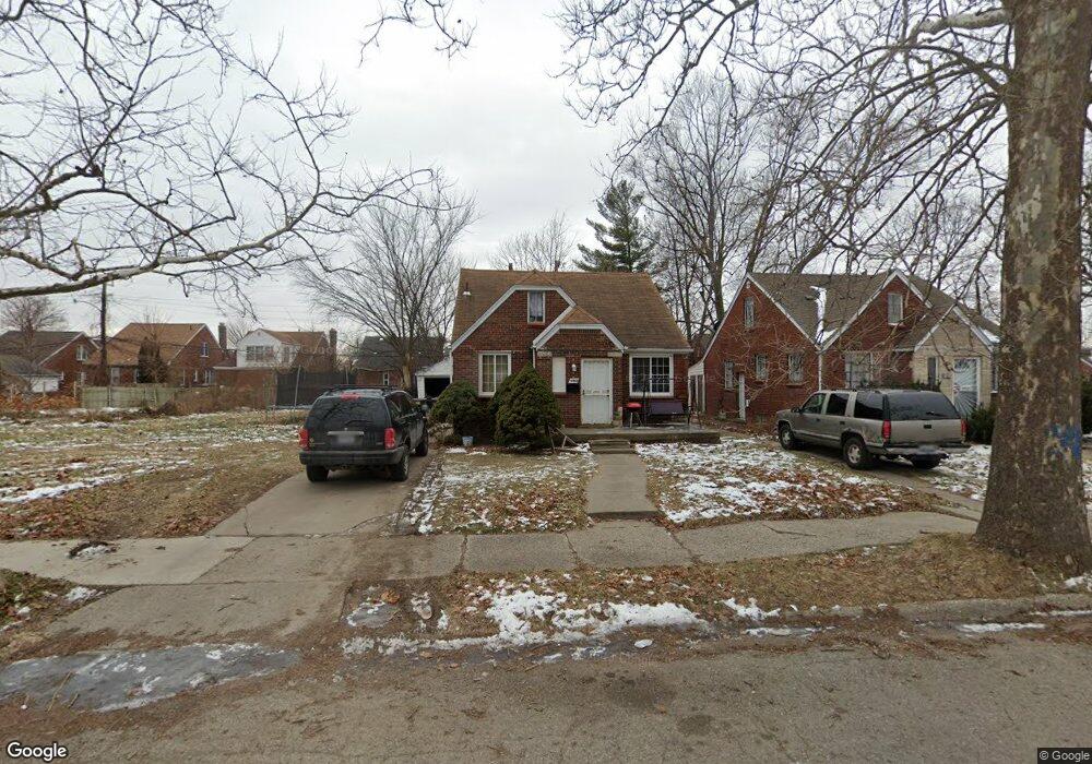
9767 Kensington Ave Detroit, MI 48224
Yorkshire Woods NeighborhoodEstimated Value: $64,000 - $90,000
3
Beds
1
Bath
1,236
Sq Ft
$64/Sq Ft
Est. Value
About This Home
This home is located at 9767 Kensington Ave, Detroit, MI 48224 and is currently estimated at $79,418, approximately $64 per square foot. 9767 Kensington Ave is a home located in Wayne County with nearby schools including Wayne Elementary School, Edward 'Duke' Ellington Conservatory of Music and Art, and Charles L. Spain Elementary-Middle School.
Ownership History
Date
Name
Owned For
Owner Type
Purchase Details
Closed on
Feb 19, 2014
Sold by
Paschal Anglia
Bought by
Curry Tayonna
Current Estimated Value
Purchase Details
Closed on
Mar 30, 2011
Sold by
Secretary Of Housing & Urban Development
Bought by
Paschal Anglia
Purchase Details
Closed on
Aug 20, 2010
Sold by
Citimortgage Inc
Bought by
The Secretary Of Housing & Urban Develop
Purchase Details
Closed on
Feb 17, 2010
Sold by
Stewart Suzanne R
Bought by
Citimortgage Inc
Create a Home Valuation Report for This Property
The Home Valuation Report is an in-depth analysis detailing your home's value as well as a comparison with similar homes in the area
Home Values in the Area
Average Home Value in this Area
Purchase History
| Date | Buyer | Sale Price | Title Company |
|---|---|---|---|
| Curry Tayonna | -- | None Available | |
| Paschal Anglia | $4,941 | None Available | |
| The Secretary Of Housing & Urban Develop | -- | None Available | |
| Citimortgage Inc | $74,198 | None Available |
Source: Public Records
Tax History Compared to Growth
Tax History
| Year | Tax Paid | Tax Assessment Tax Assessment Total Assessment is a certain percentage of the fair market value that is determined by local assessors to be the total taxable value of land and additions on the property. | Land | Improvement |
|---|---|---|---|---|
| 2025 | $807 | $29,200 | $0 | $0 |
| 2024 | $807 | $24,900 | $0 | $0 |
| 2023 | $782 | $20,200 | $0 | $0 |
| 2022 | $846 | $16,600 | $0 | $0 |
| 2021 | $827 | $11,500 | $0 | $0 |
| 2020 | $819 | $10,300 | $0 | $0 |
| 2019 | $809 | $8,900 | $0 | $0 |
| 2018 | $705 | $7,900 | $0 | $0 |
| 2017 | $152 | $8,000 | $0 | $0 |
| 2016 | $976 | $12,200 | $0 | $0 |
| 2015 | $1,220 | $12,200 | $0 | $0 |
| 2013 | $2,088 | $20,883 | $0 | $0 |
| 2010 | -- | $30,617 | $1,146 | $29,471 |
Source: Public Records
Map
Nearby Homes
- 9510 Whittier St
- 9175 Everts St
- 9801 Kensington Ave
- 9610 Whittier St
- 9257 Bishop St
- 9969 Bishop St
- 9344 Courville St
- 10253 Mckinney St
- 10024 Balfour Rd
- 10446 Balfour Rd
- 9210 King Richard St
- 10390 Somerset Ave
- 10319 Mckinney St
- 9200 King Richard St
- 10172 Somerset Ave
- 10029 Balfour Rd
- 10130 Somerset Ave
- 6111 Yorkshire Rd
- 9265 Bedford St
- 5984 Courville St
- 9775 Kensington Ave
- 9785 Kensington Ave
- 9759 Kensington Ave
- 9751 Kensington Ave
- 9791 Kensington Ave
- 9745 Kensington Ave
- 9680 Everts St
- 9666 Everts St
- 9674 Everts St
- 9658 Everts St
- 9766 Kensington Ave
- 9758 Kensington Ave
- 9690 Everts St
- 9776 Kensington Ave
- 9650 Everts St
- 9750 Kensington Ave
- 9735 Kensington Ave
- 9782 Kensington Ave
- 9700 Everts St
- 9644 Everts St