Estimated Value: $206,000 - $228,883
3
Beds
2
Baths
1,380
Sq Ft
$160/Sq Ft
Est. Value
About This Home
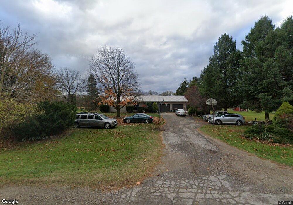
This home is located at 9797 W M 21, Ovid, MI 48866 and is currently estimated at $220,971, approximately $160 per square foot. 9797 W M 21 is a home located in Shiawassee County with nearby schools including Leonard Elementary School, E.E. Knight Elementary School, and Ovid-Elsie Middle School.
Ownership History
Date
Name
Owned For
Owner Type
Purchase Details
Closed on
Jul 29, 2021
Sold by
Brown Daniel T and Brown Aimee V
Bought by
Brown Daniel T
Current Estimated Value
Purchase Details
Closed on
Oct 12, 2010
Sold by
Brown Aimee V and Brown Daniel T
Bought by
Brown Daniel T and Daniel T Brown Trust
Home Financials for this Owner
Home Financials are based on the most recent Mortgage that was taken out on this home.
Original Mortgage
$118,404
Outstanding Balance
$77,775
Interest Rate
4.26%
Mortgage Type
FHA
Estimated Equity
$143,196
Purchase Details
Closed on
Oct 8, 2010
Sold by
Oakmont Associates Inc
Bought by
Brown Daniel T and Brown Aimee V
Home Financials for this Owner
Home Financials are based on the most recent Mortgage that was taken out on this home.
Original Mortgage
$118,404
Outstanding Balance
$77,775
Interest Rate
4.26%
Mortgage Type
FHA
Estimated Equity
$143,196
Purchase Details
Closed on
May 3, 2010
Sold by
Eastern Savings Bank Fsb
Bought by
Oakmont Associates Inc
Create a Home Valuation Report for This Property
The Home Valuation Report is an in-depth analysis detailing your home's value as well as a comparison with similar homes in the area
Home Values in the Area
Average Home Value in this Area
Purchase History
| Date | Buyer | Sale Price | Title Company |
|---|---|---|---|
| Brown Daniel T | -- | None Available | |
| Brown Daniel T | -- | -- | |
| Brown Daniel T | $120,000 | -- | |
| Oakmont Associates Inc | -- | -- |
Source: Public Records
Mortgage History
| Date | Status | Borrower | Loan Amount |
|---|---|---|---|
| Open | Brown Daniel T | $118,404 |
Source: Public Records
Tax History Compared to Growth
Tax History
| Year | Tax Paid | Tax Assessment Tax Assessment Total Assessment is a certain percentage of the fair market value that is determined by local assessors to be the total taxable value of land and additions on the property. | Land | Improvement |
|---|---|---|---|---|
| 2025 | $1,975 | $95,600 | $0 | $0 |
| 2024 | $1,889 | $94,300 | $0 | $0 |
| 2023 | $679 | $79,800 | $0 | $0 |
| 2022 | $647 | $73,200 | $0 | $0 |
| 2021 | $1,747 | $69,100 | $0 | $0 |
| 2020 | $1,728 | $66,300 | $0 | $0 |
| 2019 | $1,697 | $51,300 | $0 | $0 |
| 2018 | $1,661 | $50,400 | $0 | $0 |
| 2017 | $1,618 | $51,600 | $0 | $0 |
| 2016 | -- | $51,600 | $0 | $0 |
| 2015 | -- | $54,200 | $0 | $0 |
| 2014 | $6 | $52,100 | $0 | $0 |
Source: Public Records
Map
Nearby Homes
- 9882 W M 21
- 222 N Main St
- 217 W Clinton St
- 306 N Main St
- 210 W Front St
- 228 W Pearl St
- 218 W High St
- 2230 S Meridian Rd
- 1279 Leland Rd
- 3525 S Hollister Rd
- 6687 Winfield Rd
- 4321 N Upton Rd
- 2900 S Saint Clair Rd
- V/L S Shepardsville Rd
- Parcel B S Hollister Rd
- 0 Peninsula Way
- 4101 Shaftsburg Rd
- V/L Victoria Shore Dr
- 5752 E Colony Rd
- 5025 S Saint Clair Rd